
Pinal Airpark, also known as Pinal County Airpark, is a non-towered, county-owned, public-use airport located 8 miles northwest of the central business district of Marana, in Pinal County, Arizona, United States. Silverbell Army Heliport is co-located with Pinal Airpark. The heliport is a private-use military facility operated by the Arizona Army National Guard.

Apalachicola Regional Airport is a county-owned, public-use airport located two nautical miles (4 km) west of the central business district of Apalachicola, a city in Franklin County, Florida, United States. It is included in the National Plan of Integrated Airport Systems for 2011–2015, which categorized it as a general aviation facility. It was previously known as Apalachicola Municipal Airport. The airport supports general aviation activity in the area and provides service via a tenant fixed-base operator (FBO).

Page Field is a public airport located in Fort Myers, in Lee County, Florida, United States. It is owned by the Lee County Port Authority; the National Plan of Integrated Airport Systems for 2011–2015 categorized it as a reliever airport.
Clayton Municipal Airpark is a town owned, public use airport located two nautical miles (4 km) east of the central business district of Clayton, a town in Union County, New Mexico, United States. It is included in the National Plan of Integrated Airport Systems for 2011–2015, which categorized it as a general aviation facility.

Jacqueline Cochran Regional Airport is a county-owned, public-use airport in Riverside County, California, United States. It is located in the southeastern Coachella Valley, 20 nautical miles southeast of the central business district of Palm Springs, in Thermal, California. This airport is included in the National Plan of Integrated Airport Systems for 2011–2015, which categorized it as a general aviation facility.
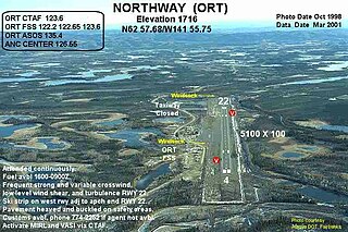
Northway Airport is a state-owned public-use airport serving Northway, a community located in the Southeast Fairbanks Census Area of the U.S. state of Alaska. It is included in the National Plan of Integrated Airport Systems for 2011–2015, which categorized it as a general aviation facility.
Buffalo Airfield is a privately owned, public use airport located six nautical miles southeast of the central business district of Buffalo, in Erie County, New York, United States. It is included in the National Plan of Integrated Airport Systems for 2011–2015, which categorized it as a reliever airport.

Cross City Airport is a county-owned, public-use airport located one nautical mile (2 km) east of the central business district of Cross City, a city in Dixie County, Florida, United States. It is included in the National Plan of Integrated Airport Systems for 2011–2015, which categorized it as a general aviation facility.

Immokalee Regional Airport is a public use airport located one nautical mile (2 km) northeast of the central business district of Immokalee, in Collier County, Florida, United States. The airport is owned by the Collier County Airport Authority. Formerly known as Immokalee Airport, it is included in the National Plan of Integrated Airport Systems for 2011–2015, which categorized it as a general aviation facility.
Thomas C. Russell Field is a city-owned public-use airport located two nautical miles (4 km) southwest of the central business district of Alexander City, a city in Tallapoosa County, Alabama, United States.

Courtland Airport is a public-use airport located two nautical miles northeast of the central business district of Courtland, a town in Lawrence County, Alabama, United States. It is owned by the Lawrence County Commission and was formerly known as Lawrence County Airport.

Florala Municipal Airport is a city-owned public-use airport located three nautical miles northeast of the central business district of Florala, a city in Covington County, Alabama, United States.

Lake Wales Municipal Airport is a public-use airport located 2 miles (3.2 km) west of the central business district of the city of Lake Wales in Polk County, Florida, United States. The airport is publicly owned.

Crisp County–Cordele Airport is a county-owned, public-use airport located two nautical miles (4 km) northeast of the central business district of Cordele, a city in Crisp County, Georgia, United States. It is included in the National Plan of Integrated Airport Systems for 2011–2015, which categorized it as a general aviation facility. The airport does not have scheduled commercial airline service.

Orangeburg Municipal Airport is a city-owned, public-use airport located two nautical miles (4 km) south of the central business district of Orangeburg, a city in Orangeburg County, South Carolina, United States. It is included in the National Plan of Integrated Airport Systems for 2011–2015, which categorized it as a general aviation facility. The airport does not have scheduled commercial airline service.

Barnwell Regional Airport is a county-owned, public-use airport located 1 nautical mile northwest of the central business district of Barnwell, a city in Barnwell County, South Carolina, United States. It is owned by Barnwell County. The airport serves the general aviation community, with no scheduled commercial airline service.

Georgetown County Airport is a county-owned, public-use airport located three nautical miles (6 km) south of the central business district of Georgetown, a city in Georgetown County, South Carolina, United States. It is included in the National Plan of Integrated Airport Systems for 2011–2015, which categorized it as a general aviation facility. The airport does not have scheduled commercial airline service.

Cleveland Municipal Airport is a public use airport in Bolivar County, Mississippi, United States. It is owned by the City of Cleveland and located two nautical miles (4 km) northwest of its central business district. This airport is included in the National Plan of Integrated Airport Systems for 2011–2015, which categorized it as a general aviation facility. There is no scheduled commercial airline service.

Manila Municipal Airport is a public-use airport located two nautical miles northeast of the central business district of Manila, in Mississippi County, Arkansas, United States. It is owned by the City of Manila.
Naval Outlying Field Goliad is a military airport located five nautical miles north of the central business district of Berclair, Texas, in Goliad County. It is owned by the United States Navy. The airfield has two runways, both 8000 feet long by 150 feet wide. Its mission is to support operations of the Naval Air Training Command, specifically Commander, Training Air Wing FOUR located aboard Naval Air Station Corpus Christi. It is under the control of Commander, Navy Region Southeast.


