Khalilabad, India

Last updated

Khalilabad
City of Khalilabad.jpg
India Uttar Pradesh location map.svg
Red pog.svg
Khalilabad
Location in Uttar Pradesh, India
Coordinates: 26°47′N83°04′E / 26.78°N 83.07°E / 26.78; 83.07
CountryFlag of India.svg  India
State Uttar Pradesh
District Sant Kabir Nagar
EstablishedJun 1680
Founded byQazi Khalil-ur-Rahman (Representative of Aurangzeb Mughal emperor in this area at that time)
Named for Qazi Khalil-ur-Rahman
Government
   MP Praveen Nishad
   MLA Ankur Raj Tiwari
Area
  Total26 km2 (10 sq mi)
Elevation
69 m (226 ft)
Population
 (2011)
  Total47,847
  Density1,042/km2 (2,700/sq mi)
Demonym Khalilabadi
Languages
  Official Hindi, English, Urdu
  Regional Bhojpuri
Time zone UTC+5:30 (IST)
PIN
272175
Vehicle registration UP-58
Website http://sknagar.nic.in/

Khalilabad is a city and a municipal board in Sant Kabir Nagar district in the Indian state of Uttar Pradesh. It is the district headquarters of Sant Kabir Nagar district.

Contents

Geography

Khalilabad lies on the Ayodhya-Gorakhpur road and is around 36 km west of Gorakhpur and 36 km east of Basti. Khalilabad lies in Lat. 26 47'N. and Long. 83 4' E. This is the center point of Gorakhpur and Basti. It is the headquarters of this new district Sant Kabir Nagar.

The town is small but has a history that can be traced back to the Mughal emperors. The place got its name from its founder, Qazi Khalil-ur-Rahman, who was appointed chakladar of Gorakhpur about 1860 AD.

At present this place is more famous for its fabric wholesalers, Readymade Garment Retailers, and much more, popularly known as Bardahia Bazar. The tehsil building, situated to the south of the road to Gorakhpur, is an imposing structure created after the first freedom struggle in 1857 in which the place was sacked.

Climate

The climate of the district is more equable than the adjoining districts to the south. The year may be divided into four seasons. The winter season, from mid-November to February, is followed by the summer season lasting till about the middle of June. The period from mid-June to the end of September constitutes the southwest monsoon season. October to mid-November is the post-monsoon or transition period.

Rainfall: The average annual rainfall in the district is 1166 mm.

Temperature: During the winter seasons, the mean minimum temperature is about 9 degrees Celsius, and the mean maximum is 23 degrees Celsius, while during the summer seasons the minimum is about 25 degrees Celsius and the mean maximum is about 44 degrees Celsius.

Humidity: In the southwest monsoon and the post-monsoon seasons, the relative humidity is high, above 70 percent. Thereafter the humidity decreases and in the summer the air is very dry.

Cloudiness: During the monsoon season, and for brief spells of a day or two in association with passing disturbances in winter, heavily clouded or overcast skies prevail. During the rest of the year, the skies are mostly clear or lightly clouded.

Winds: Winds are in general very light with a slight increase in force in the late summer and monsoon seasons. The average annual wind blow in the district ranges from 2 to 7.1  km/hrs.

River system and water resources

The Ami, the chief tributary of the Rapti, is a stream that commences at a short distance from Rapti in Rasulpur and issues from a large tract of paddy land.

The lakes of the district are numerous and several are of considerable size. They are most commonly formed by the changes in the river channels, while in other cases the natural depressions in which the surface of water collects, are generally due in some measure to fluvial action. The largest and the most celebrated lake in the district is the Bakhira or Badhanchh Tal, sometimes called the Moti Jhil, which lies on the eastern borders of the district between Bakhira and Mehdawal. This lake, though seldom more than two meters in depth, covers a very large area of about 12  km. long and 4  km. broad. The water in the lake is largely derived from the overflow from Rapti. Ghaghra popular as the Saryu river, Kuano river, and Kathinaiya river is also situated in the district.

Transport

Road

NH 27 and NH 28A pass through Khalilabad.(Ragadganj)

Railway

Railway Station Khalilabad is on the Gorakhpur-Lucknow line.

Airlines

The nearest airport is in Gorakhpur. Drive duration is approx 1 hour.

Gorakhpur to Delhi

AirlineDeparture (UTC +5:30)Arrival (UTC +5:30)Duration
Air India (AI-9810)16:1518:152h Non Stop
SpiceJet (SG-8379)11:3013:051h 35m Non Stop
IndiGo (6E-138)10:3012:352h 05m Non Stop

Delhi to Gorakhpur

AirlineDeparture (UTC +5:30)Arrival (UTC +5:30)Duration
Air India (AI 9809)13:3515:352h 00m Non Stop
SpiceJet (SG 8475)09:1511:001h 45m Non Stop
IndiGo (6E-826)08:5009:3040m Non Stop

Gorakhpur to Mumbai

AirlineDeparture (UTC +5:30)Arrival (UTC +5:30)Duration
SpiceJet (SG-415)14:0016:352h 35m Non Stop
SpiceJet (SG-453)16:2018:502h 30m Non Stop
IndiGo (6E-137)12:3015:202h 50m Non Stop

Mumbai to Gorakhpur

AirlineDeparture (UTC +5:30)Arrival (UTC +5:30)Duration
SpiceJet (SG-452)13:2515:452h 20m Non Stop
SpiceJet (SG-438)10:5513:202h 25m Non Stop
IndiGo (6E-136)09:2511:452h 20m Non Stop

Demographics

Khalilabad is a Nagar Palika Parishad city in the district of Sant Kabir Nagar, Uttar Pradesh. The Khalilabad city is divided into 25 wards for which elections are held every 5 years. The Khalilabad Nagar Palika Parishad has a population of 47,847 of which 25,154 are males while 22,693 are females as per a report released by Census India 2011.

The population of Children with age 0-6 is 6274 which is 13.11 % of the total population of Khalilabad (NPP). In Khalilabad Nagar Palika Parishad, the Female Sex Ratio is 902 against the state average of 912. Moreover, the Child Sex Ratio in Khalilabad is around 900 compared to the Uttar Pradesh state average of 902. The literacy rate of Khalilabad City is 82.06 % higher than the state average of 67.68 %. In Khalilabad, Male literacy is around 88.68 % while the female literacy rate is 74.72 %.

Khalilabad Nagar Palika Parishad has total administration of over 7,291 houses to which it supplies basic amenities like water and sewerage. It is also authorized to build roads within Nagar Palika Parishad limits and impose taxes on properties coming under its jurisdiction.

[1]

Religions in Khalilabad
ReligionPercent
Hindus
68.79%
Muslims
30.08%
Christianity
0.26%
Sikhism
0.39%
Jainism
0.06%
Buddhism
0.03%
Others
0.39%

Related Research Articles

<span class="mw-page-title-main">Sant Kabir Nagar district</span> District of Uttar Pradesh in India

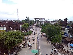
Sant Kabir Nagar district is one of the 75 districts of Uttar Pradesh state in northern India. Khalilabad is the district headquarters. Sant Kabir Nagar district is a part of Basti division. The total area of Sant Kabir Nagar district is 1,646 km2 (636 sq mi).

<span class="mw-page-title-main">Robertsganj</span> City in Uttar Pradesh, India

Robertsganj also known as Sonbhadra City is a city and a municipal board in Sonbhadra district in the Indian state of Uttar Pradesh.

Bansi is a city and municipal board situated on a bank of the Rapti River in the Siddharthnagar district in the state of Uttar Pradesh, India. It is one of the five vidhan sabha constituencies in Siddharthnagar district and one of the most important cities of the district. The Indo Nepal border is near to the town around 40 km. Lumbini of Nepal is the best place to visit from Bansi by crossing the open border between Nepal and India. The Magh Mela is a fair which is held for a month in Bansi from 25 January to 25 February, attracting visitors from all the surrounding areas.

Bilariaganj is the second largest city and a Nagar Palika Parishad in Azamgarh division after its capital city Azamgarh in the state of Uttar Pradesh, India.

Chhibramau is a nagar palika parishad and a subdivision (tehsil) of Kannauj district in the northern state of Uttar Pradesh, India.

Gursarai is a city and municipal board in the Jhansi district of the Indian state of Uttar Pradesh. Gursarai is situated in the Garautha Tehsil. An emerging city in Jhansi District With having an old and established market, it's a lifeline for the nearby village people who come and sell their farm produces.

Maudaha is a city and a Municipal Board in Hamirpur district, Uttar Pradesh, India.

Noorpur is a City and a Municipal Board in Bijnor District in the Indian State of Uttar Pradesh.

Sarsawa is a town at the border of Haryana and a municipal board in Saharanpur district in the Indian state of Uttar Pradesh.

Tanda is a town in Ambedkar Nagar district in the Indian state of Uttar Pradesh situated on the banks of Ghaghara River. It is a nagar palika parishad and is part of Ayodhya division in Uttar Pradesh. The town is situated 20 kilometres (12 mi) north east from district headquarter Akbarpur. Tanda is also a tehsil in the district. It has one of the largest handloom weaving industries for manufacturing varieties like gamchha, lungi, polyester clothing, check-shirt clothes material in state of Uttar Pradesh.

National Highway 28 is a National Highway in India that links Lucknow in Uttar Pradesh to Barauni in Bihar. It crosses into Bihar about 20 km (12 mi) from Kushinagar. It joins National Highway 31 at Barauni north of the river Ganges. The total length of NH 28 is 570 km (350 mi). It traverses 259 km (161 mi) in Bihar and 311 km (193 mi) in Uttar Pradesh.

<span class="mw-page-title-main">Bakhira Sanctuary</span> Protected wetland in India

The Bakhira Bird Sanctuary is the largest natural flood plain wetland of India in Sant Kabir Nagar district of Eastern Uttar Pradesh. The sanctuary was established in 1980. It is situated 44 km west of Gorakhpur city 18 km away from khalilabad and 55 km away from basti. It is a vast stretch of water body expanding over an area of 29 km2. This is an important lake of eastern UP, which provides a wintering and staging ground for a number of migratory waterfowls and a breeding ground for resident birds. This is also used for farming activities as it is connected to Bakhira Canal which covers the people of 15 km from its origin. The sanctuary is named after the village Bakhira located adjacent to the lake along with as many as hundred and eight villages surrounding the lake within the 5 km radius. The villagers from the surrounding villages depend on the wetland for their livelihood in the form of fishing, agricultural activities and fuelwood collection from it. The Siberians birds travel across 5000 km to get to these wetlands at the time of winter's.

<span class="mw-page-title-main">Basti, Uttar Pradesh</span> City in Uttar Pradesh, India

Basti is a city, municipal board and administrative headquarters of Basti district in the Indian state of Uttar Pradesh. Basti district is a part of Basti division. It is situated 202 kilometres east of state capital Lucknow.

Ashthabhuja Prasad Shukla is an Indian politician. He represented the Khalilabad constituency in the Lok Sabha during 1991-1996. He is a member of Bharatiya Janata Party (BJP).

<span class="mw-page-title-main">West Rapti River</span> River in Nepal

West Rapti, also known as the Kuwano, is a river which drains Rapti Zone in Mid-Western Region, Nepal, then Awadh and Purvanchal regions of Uttar Pradesh state, and finally India before joining the Ghaghara. It is a major left bank tributary of the Ganges, and is also known as the Karnali inside Nepal.

Dr Mohamed Ayub or Dr. Ayub is an Indian politician and president of Peace Party of India. He Is MLA in Sixteenth Legislative Assembly of Uttar Pradesh. Since 2012 he represents Khalilabad in Sant Kabir Nagar district as a member of Peace Party of India.

Khajuriya Sarki is a village near Dhebarua in Shoratgarh Assembly Constituency of Siddharthnagar District, Uttar Pradesh state, India. The village has a nearby railway station Barhni on the Gorakhpur–Gonda Indian Railways. It is 6 km from the Nepal border Krishnanagar (JhandeNagar).

Khalilabad railway station is a railway station in Sant Kabir Nagar district, Uttar Pradesh. Its code is KLD. The station serves the city of Khalilabad. The station consists of three platforms. The platforms are well sheltered.

Belauli is a village in the Mehdawal tehsil of Sant Kabir Nagar district, Uttar Pradesh state, India.

Dharamsinghwa, also spelt as Dharmsinghwa and Dharmsinghawa, is a town and a newly formed Nagar Panchayat in the Sant Kabir Nagar district of the Uttar Pradesh state of India. It is situated about 40 kilometres north of the district headquarters, Khalilabad. The town is known for its Kushan-era Buddhist Stupa.

References

  1. "Sant Kabir Nagar District Population Census 2011-2021, Uttar Pradesh literacy sex ratio and density".