Rufiji is one of the six districts of the Pwani Region of Tanzania. It is bordered to the north by the Kisarawe and Mkuranga Districts, to the east by the Indian Ocean, to the south by the Kilwa District, Lindi Region and to the west by the Morogoro Region. The district capital is the town of Utete on the southern banks of the Rufiji River.

Pwani Region is one of Tanzania's 31 administrative regions. The word "Pwani" in Swahili means the "coast". The regional capital is the town of Kibaha. The Region borders the Tanga Region to the north, Morogoro Region to the west, Lindi Region to the south, and surrounds Dar es Salaam Region to the east. The Indian Ocean also borders the region to its northeast and southeast. The region is home to Mafia Island, the Rufiji delta and Saadani National Park. The region is home to Bagamoyo town, a historical Swahili settlement, and the first colonial capital of German East Africa. According to the 2012 national census, the region had a population of 1,098,668, which was slightly lower than the pre-census projection of 1,110,917. From 2002 to 2012, the region's 2.2 percent average annual population growth rate was the seventeenth-highest in the country. It was also the 21st most densely populated region with 34 people per square kilometre., According to the 2022 census the population had nearly doubled to 2,024,947. the region is slightly larger than Belgium.

Tanga Region is one of Tanzania's 31 administrative regions. The region covers an area of 26,667 km2 (10,296 sq mi). The region is comparable in size to the combined land area of the nation state of Burundi. The regional capital is the municipality of Tanga city. Located in northeast Tanzania, the region is bordered by Kenya and Kilimanjaro Region to the north; Manyara Region to the west; and Morogoro and Pwani Regions to the south. It has a coastline to the east with the Indian Ocean. According to the 2022 national census, the region had a population of 2,615,597.

Ubungo District, officially the, Ubungo Municipal Council is one of five districts of the Dar es Salaam Region of Tanzania. The Kinondoni District and Kibaha of the Pwani Region border the district to the north; the Kisarawe District of Pwani Region borders it to the west; and the Ilala District borders the it to the south and east. The district covers an area of 269.4 km2 (104.0 sq mi). The district is comparable in size to the land area of St. Kitts and Nevis. The administrative seat is Kwembe. The district is home to the University of Dar es Salaam, The Magufuli Bus Terminal, the largest in the country, and Pande Game Reserve the largest protected land area in Dar es Salaam Region. In addition, the district is home to the largest natural gas powered power station, the Ubungo Thermal Power Station and the headquarters of the Tanzania Electric Supply Company Limited (TANESCO). The 2012 National Tanzania Census states the population of the district as 845,368.

Bagamoyo District Council is one of eight administrative districts of Pwani Region in Tanzania. The District covers an area of 945 km2 (365 sq mi). The district is surrounded by the Chalinze District to the north and west, the Zanzibar Channel to the east, the Kibaha District to the south, and the Kinondoni District to the south-east in the Dar es Salaam Region. The district is comparable in size to the land area of Turks and Caicos Islands. The district capital is at Bagamoyo. 1n 2016 the Tanzania National Bureau of Statistics report there were 106,484 people in the district, from 311,740 in 2012, of which 97,660 where in current district wards. The decrease being from splitting of the district and creation of the Chalinze District in 2015.

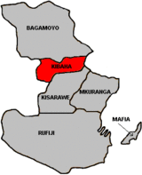
Kisarawe District Council is one of eight administrative districts of Pwani Region in Tanzania. The District covers an area of 5,031 km2 (1,942 sq mi). It is bordered to the east by Dar es Salaam Region's Ilala and Ubungo Municipal Councils. The Kibaha District and Kibaha Town Council border the district to the north, and the Mkuranga District and Kibiti District border it to the south-east. By the Rufiji District to the south, and the Morogoro District of the Morogoro Region to the west. The district is comparable in size to the land area of Trinidad and Tobago. The town of Kisarawe serves as its administrative capital. According to the 2022 Tanzania National Census, the population of the District was 159,226.

Liwale is one of the six districts of the Lindi Region of Tanzania. It is the largest district in Lindi and one of the largest in districts in Tanzania. It is bordered to the north by the Pwani Region, to the east by the Kilwa District, to the south by the Ruangwa District and to the west by the Morogoro Region. Most of Liwale district is within the Nyerere National Park.

Mvomero is one of the six districts of the Morogoro Region of Tanzania. It is bordered to the north by the Tanga Region, to the northeast by the Pwani Region, to the east and southeast by Morogoro Rural District and Morogoro Urban District and to the west by Kilosa District.

The Kwere also known as Ngh'wele are a matrilineal ethnic and linguistic group native to Bagamoyo District and Chalinze District in Pwani Region of coastal Tanzania. The primary language spoken is Ngh'wele, called Kikwere in Swahili. The most famous person of Kwere descent is former President of Tanzania Jakaya Kikwete.

The following outline is provided as an overview of and topical guide to Tanzania:
Ruvu is a small town and ward (shehia) located in the Kibaha District of the Pwani Region in eastern Tanzania, west of Dar es Salaam. As of 2002, the ward population was 6,697.
Kibaha Secondary School is a Tanzanian all-boys secondary school located in Kibaha, Kibaha District, Pwani Region.

Kibaha is one of nine administrative districts of Pwani Region in Tanzania. The name means '"it is here" in Zaramo. The District covers an area of 1,502 km2 (580 sq mi). Kibaha District is bordered to the northeast by Kibaha Urban District and the north by Chalinze District. The district is bordered to the southeast by the Kisarawe District, On the western side the district is borderd by Morogoro District of Morogoro Region. The district seat (capital) is the town and ward of Mlandizi. According to the 2012 census, the district has a total population of 70,209.
Kibaha Education Centre(KEC) is an education institution located in Kibaha in Tanzania. It Is situated at 6°47'22.2"S, 38°58'28.7"E in Kibaha municipal council. KEC was established in 1963 under the co-sponsorship o five countries, the government of Tanganyika (now Tanzania) on one side as well as four Nordic countries (Denmark, Finland, Norway and Sweden). Before handing over to the Tanzania government in 1970, KEC was known as the Nordic-Tanganyika project.
Soga is a village and a ward in the Pwani Region of Tanzania. It is located in Kibaha District.

Chalinze District Council is one of nine administrative districts of Pwani Region in Tanzania. The district covers an area of 8,042 km2 (3,105 sq mi). The district is comparable in size to the land area of Puerto Rico. Chalinze District is bordered to the northeast by Pangani District, the north by Handeni District and in Kilindi District of Tanga Region. The district is bordered to the east by the Indian Ocean. Chalinze is also borders Bagamoyo District, Kibaha Urban District and to the South by Kibaha District. On the western part, the district is bordered by Mvomero District and Morogoro Rural District of Morogoro Region.

Mchinga is an administrative ward and capital of Kibaha District in Pwani Region of Tanzania. The ward covers an area of 84.6 km2 (32.7 sq mi), and has an average elevation of 60 m (200 ft). According to the 2012 census, the ward has a total population of 17,318.
Mabwepande is an administrative ward in Kinondoni District of the Dar es Salaam Region in Tanzania. Bunju and Wazo wards form the ward's eastern boundary. The Mbezi ward of Ilala District borders the ward to the south. Pangani ward of Kibaha Town Council and Kerege ward of Bagamoyo District in Pwani Region border the wards to the west and north, respectively. According to the 2012 census, the ward has a total population of 25,460.