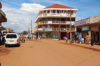
Jinja is a city in the Eastern Region of Uganda, located on the north shore of Lake Victoria.

Nalubaale Power Station, formerly known as Owen Falls Dam, is a hydroelectric power station across the White Nile near its source at Lake Victoria in Uganda. Nalubaale is the Luganda name for Lake Victoria.

Mukono is one of the districts in the Central Region of Uganda. The town of Mukono is home to the district's main commercial center and district headquarters.

The Owen Falls was a waterfall on the White Nile in Uganda near the city of Jinja. The falls, together with the nearby Ripon Falls, were submerged in 1954 with the completion of the Nalubaale Hydroelectric Power Station. The dam that houses the power station was originally named Owen Falls Dam, but was later renamed Nalubaale Dam and the name of the power station was also changed, from Owen Falls Power Station to Nalubaale Power Station.

Bujagali Falls was a waterfall near Jinja in Uganda where the Nile River comes out of Lake Victoria, sometimes considered the source of the Nile. Starting November 2011, the falls were submerged by the new Bujagali Power Station.
Articles related to Uganda include:

Burning of renewable resources provides approximately 90 percent of the energy in Uganda, though the government is attempting to become energy self-sufficient. While much of the hydroelectric potential of the country is untapped, the government decision to expedite the creation of domestic petroleum capacity coupled with the discovery of large petroleum reserves holds the promise of a significant change in Uganda's status as an energy-importing country.
Njeru is a town in Buikwe District, in the Central Region of Uganda. It is the largest town in the district. It is mainly a residential town. However, it hosts industries such as East African Packaging Solutions Limited, a manufacturer of paper packaging supplies, Nile Breweries Limited, a subsidiary of AB InBev and Nyanza Textile Industries Limited (Nytil), a textile manufacturer.
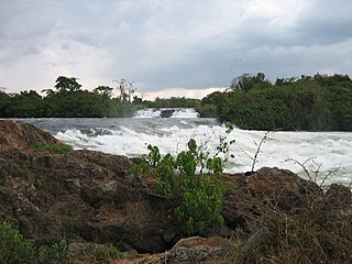
The Bujagali Power Station is a hydroelectric power station across the Victoria Nile that harnesses the energy of its namesake, the Bujagali Falls, in Uganda. Construction began in 2007 and concluded in 2012. It was officially inaugurated on 8 October 2012 by Ugandan President Yoweri Museveni and Aga Khan IV in the presence of African politicians and investors.

Kiira Hydroelectric Power Station is a hydroelectric power station in Uganda, with an installed capacity of 200 megawatts (270,000 hp).
The Kampala–Jinja Highway is a road in Uganda, connecting the cities of Kampala and Jinja. Sometimes referred to as Kampala–Jinja Road, it is a busy road, with several towns, trading centers and other points of interest along the way. As of October 2016, a new, wider, four-lane dual carriageway expressway, the Kampala–Jinja Expressway, is proposed to be constructed south of the present highway to relieve traffic and complement existing transport infrastructure between Kampala and Jinja.
Jinja Airport is a small civilian and military airport in Uganda. It serves the town of Jinja in Jinja District, Busoga, Eastern Region. It is adjacent to the Uganda Senior Command and Staff College of the Uganda People's Defence Force at Kimaka, a suburb of Jinja. It is approximately 95 kilometres (59 mi), by air, east of Entebbe International Airport, the country's largest airport. Jinja Airport is one of 13 upcountry airports that are administered by the Uganda Civil Aviation Authority.
The Uganda Senior Command and Staff College (USCSC) is a training facility for senior commanders in the Uganda People's Defense Force (UPDF), including the army, air force, and special forces.

The Source of the Nile Bridge, also New Jinja Bridge, which was commissioned on 17 October 2018, by the President of Uganda, is a cable-stayed bridge across the Victoria Nile in Uganda. It replaced the Nalubaale Bridge, which was built in 1954.
Bujagali Energy Limited (BEL) is an electric energy generating company in Uganda. The company owns and operates the Bujagali Power Station, the largest hydropower plant in the country as of July 2014.
The Uganda Electricity Generation Company Limited (UEGCL) is a parastatal company whose primary purpose is to generate electric power for use in Uganda and for sale to neighboring countries. As of December 2017, UEGCL's generation capacity was 380 megawatts, with that capacity planned to increase to over 1,300 megawatts, by 2023.
Eskom Uganda or Eskom Uganda Limited (EUL) is the largest generator of energy in Uganda and was incorporated in 2002 for a 20 year concession under a government regulatory framework.
Nyanza Textile Industries Limited(Nytil), is an integrated textile manufacturing company in Uganda.
Bujagali–Tororo–Lessos High Voltage Power Line is a high voltage electricity power line, under construction, connecting the high voltage substation at Bujagali, in Uganda to another high voltage substation at Lessos, in Kenya.
The Kamuli–Bukungu Road is a road in the Eastern Region of Uganda, connecting the towns of Kamuli in Kamuli District to Bukungu in Buyende District, on the shores of Lake Kyoga, adjacent to where the Victoria Nile enters that lake. This road, together with the connecting Jinja-Kamuli-Mbulamuti Road form a continuous transport corridor, connecting the northern shores of Lake Nalubaale to the southern shores of Lake Kyoga.

