The geography of Antarctica is dominated by its south polar location and, thus, by ice. The Antarctic continent, located in the Earth's southern hemisphere, is centered asymmetrically around the South Pole and largely south of the Antarctic Circle. It is washed by the Southern Ocean or, depending on definition, the southern Pacific, Atlantic, and Indian Oceans. It has an area of more than 14 million km2. Antarctica is the largest ice desert in the world

The history of Antarctica emerges from early Western theories of a vast continent, known as Terra Australis, believed to exist in the far south of the globe. The term Antarctic, referring to the opposite of the Arctic Circle, was coined by Marinus of Tyre in the 2nd century AD.

The Ross Dependency is a region of Antarctica defined by a sector originating at the South Pole, passing along longitudes 160° east to 150° west, and terminating at latitude 60° south. It is claimed by New Zealand. Since the Antarctic Treaty came into force in 1961, Article IV of which states: "No acts or activities taking place while the present Treaty is in force shall constitute a basis for asserting, supporting or denying a claim to territorial sovereignty in Antarctica or create any rights of sovereignty in Antarctica", most countries do not recognise territorial claims in Antarctica.

The Ross Sea is a deep bay of the Southern Ocean in Antarctica, between Victoria Land and Marie Byrd Land and within the Ross Embayment, and is the southernmost sea on Earth. It derives its name from the British explorer James Ross who visited this area in 1841. To the west of the sea lies Ross Island and Victoria Land, to the east Roosevelt Island and Edward VII Peninsula in Marie Byrd Land, while the southernmost part is covered by the Ross Ice Shelf, and is about 200 miles (320 km) from the South Pole. Its boundaries and area have been defined by the New Zealand National Institute of Water and Atmospheric Research as having an area of 637,000 square kilometres (246,000 sq mi).

The Antarctic Peninsula, known as O'Higgins Land in Chile and Tierra de San Martín in Argentina, and originally as Graham Land in the United Kingdom and the Palmer Peninsula in the United States, is the northernmost part of mainland Antarctica.

Thurston Island is an ice-covered, glacially dissected island, 215 km (134 mi) long, 90 km (56 mi) wide and 15,700 km2 (6,062 sq mi) in area, lying a short way off the northwest end of Ellsworth Land, Antarctica. It is the third largest island of Antarctica, after Alexander Island and Berkner Island.

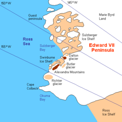
Alexandra Mountains is a group of low, separated mountains in the north portion of Edward VII Peninsula, just southwest of Sulzberger Bay in Marie Byrd Land, Antarctica. Discovered in January–February 1902 by the British National Antarctic Expedition during an exploratory cruise of the Discovery along the Ross Ice Shelf. Named for Alexandra, then Queen of the United Kingdom.

Marie Byrd Land (MBL) is an unclaimed region of Antarctica. With an area of 1,610,000 km2 (620,000 sq mi), it is the largest unclaimed territory on Earth. It was named after the wife of American naval officer Richard E. Byrd, who explored the region in the early 20th century.
This is a list of extreme points in Antarctica.

West Antarctica, or Lesser Antarctica, one of the two major regions of Antarctica, is the part of that continent that lies within the Western Hemisphere, and includes the Antarctic Peninsula. It is separated from East Antarctica by the Transantarctic Mountains and is covered by the West Antarctic Ice Sheet. It lies between the Ross Sea, and the Weddell Sea. It may be considered a giant peninsula, stretching from the South Pole towards the tip of South America.
Sulzberger Bay is a bay between Fisher Island and Vollmer Island, along the coast of King Edward VII Land. Discovered by the Byrd Antarctic Expedition on December 5, 1929, and named by Byrd for Arthur H. Sulzberger, publisher of The New York Times, a supporter of the Byrd expeditions in 1928–1930 and 1933–1935.
Shirase Coast is the north segment of the relatively ill-defined coast along the east side of Ross Ice Shelf and Ross Sea, lying between the north end of Siple Coast and Cape Colbeck. Named by NZ-APC in 1961 after Lieutenant Nobu Shirase (1861-1946), leader of the Japanese expedition, whose ship Kainan Maru sailed near this coast in January 1912. Landings were made at Kainan Bay and at the Bay of Whales, the origin of a 160-mile journey southeast on Ross Ice Shelf. From 76°56′S155°55′W, another party landed for a sledge trip to the edge of the Queen Alexandra Range.
Cape Colbeck is a prominent ice-covered cape which forms the northwestern extremity of the Edward VII Peninsula and Marie Byrd Land in Antarctica. It was discovered in January 1902 by the British National Antarctic Expedition and named for Captain William Colbeck, Royal Naval Reserve, who commanded Robert Scott's relief ship, the Morning.
Guest Peninsula is a snow-covered peninsula about 45 miles (70 km) long between the Sulzberger Ice Shelf and Block Bay, on Saunders Coast in the northwest part of Marie Byrd Land, Antarctica. Mitchell Peak, located on the peninsula, was sighted by the first Byrd Antarctic Expedition in 1929. This feature was defined and mapped as "Guest Island" by the United States Antarctic Service Expedition in 1940. It was determined to be a peninsula by U.S. Geological Survey cartographers from air photos taken by the U.S. Navy, 1962–65. It is named for Amy Guest, a contributor to the Second Byrd Antarctic Expedition, 1933–35.
Okuma Bay is a bay located at 77° 50' S 158° 20' W on the Ross Ice Shelf of Antarctica at its juncture with Edward VII Peninsula.

The Japanese Antarctic Expedition of 1910–12, in the ship Kainan Maru, was the first such expedition by a non-European nation. It was concurrent with two major Antarctic endeavours led respectively by Roald Amundsen and Robert Falcon Scott, and has been relatively overlooked in polar history. After failing to land in its first season, the Japanese expedition's original aim of reaching the South Pole was replaced by less ambitious objectives, and after a more successful second season it returned safely to Japan, without injury or loss of life.

Nobu Shirase was a Japanese army officer and explorer. He led the first Japanese Antarctic Expedition, 1910–12, which reached a southern latitude of 80°5′, and made the first landing on the coast of King Edward VII Land.
The Swinburne Ice Shelf, is an ice shelf just north of Edward VII Peninsula and the Alexandra Mountains in the southern part of Sulzberger Bay, Antarctica. The ice shelf is twenty miles (32 km) long and five miles (8 km) wide and extends from Fisher Island to White Islands. It was photographed from aircraft and mapped by the Byrd Antarctic Expedition (ByrdAE), 1928–30. Named by Advisory Committee on Antarctic Names (US-ACAN) for Captain H.W Swinburne, Jr., Deputy Commander and Chief of Staff, U.S. Naval Support Force, Antarctica, during Operation Deep Freeze 1970 and 1971.
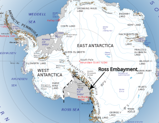
The Ross Embayment is a large region of Antarctica, comprising the Ross Ice Shelf and the Ross Sea, that lies between East and West Antarctica.