
The Maluku Islands or the Moluccas are an archipelago in the eastern part of Indonesia. Tectonically they are located on the Halmahera Plate within the Molucca Sea Collision Zone. Geographically they are located east of Sulawesi, west of New Guinea, and north and east of Timor. Lying within Wallacea, the Moluccas have been considered as a geographical and cultural intersection of Asia and Oceania.

Sultan is a position with several historical meanings. Originally, it was an Arabic abstract noun meaning "strength", "authority", "rulership", derived from the verbal noun سلطة sulṭah, meaning "authority" or "power". Later, it came to be used as the title of certain rulers who claimed almost full sovereignty without claiming the overall caliphate, or to refer to a powerful governor of a province within the caliphate. The adjectival form of the word is "sultanic", and the state and territories ruled by a sultan, as well as his office, are referred to as a sultanate.
South Sulawesi is a province in the southern peninsula of Sulawesi, Indonesia. The Selayar Islands archipelago to the south of Sulawesi is also part of the province. The capital and largest city is Makassar. The province is bordered by Central Sulawesi and West Sulawesi to the north, the Gulf of Bone and Southeast Sulawesi to the east, Makassar Strait to the west, and Flores Sea to the south.

North Maluku is a province of Indonesia. It covers the northern part of the Maluku Islands, bordering the Pacific Ocean to the north, the Halmahera Sea to the east, the Molucca Sea to the west, and the Seram Sea to the south. It shares maritime borders with North Sulawesi, Southeast Sulawesi and Central Sulawesi to the west, Maluku to the south, Southwest Papua to the west, and Palau and the Philippines to the north. The provincial capital is Sofifi on the largest island of Halmahera, while the largest city is the island city of Ternate. The population of North Maluku was 1,038,087 in the 2010 census, making it one of the least-populous provinces in Indonesia, but by the 2020 Census the population had risen to 1,282,937, and the official estimate as at mid 2022 was 1,319,338.

North Sulawesi is a province of Indonesia. It is located on the Minahasa Peninsula of the island of Sulawesi, south of the Philippines and southeast of Sabah, Malaysia. It borders the Philippine province of Davao Occidental and Soccsksargen regions of the Philippines to the north, the Maluku Sea to the east, Gorontalo and Celebes Sea to the west and the Gulf of Tomini to the southwest. With the outlying island of Miangas to its north, it is the northernmost island of Indonesia. The province's area is 14,500.28 square kilometres (5,598.59 sq mi), and its population was 2,270,596 according to the 2010 census; this rose to 2,621,923 at the 2020 Census, while the official estimate as at mid 2022 was 2,659,543. North Sulawesi is known as a heaven for divers around the world.

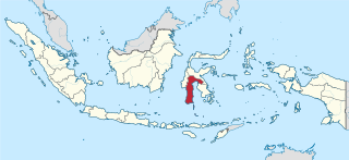
Seram is the largest and main island of Maluku province of Indonesia, despite Ambon Island's historical importance. It is located just north of the smaller Ambon Island and a few other adjacent islands, such as Saparua, Haruku, Nusa Laut and the Banda Islands.

Saparua is an island east of Ambon Island in the Indonesian province of Maluku; the island of Haruku lies between Saparua and Ambon. The main port is in the south at Kota Saparua. The island of Maolana is located near its southwestern side and Nusa Laut off its southeastern tip.

West Papua, formerly Irian Jaya Barat, is a province of Indonesia. It covers most of the two western peninsulas of the island of New Guinea, the eastern half of the Bird's Head Peninsula and the whole of the Bomberai Peninsula, along with nearby smaller islands. The province is bordered to the north by the Pacific Ocean, to the west by Southwest Papua Province, the Halmahera Sea and the Ceram Sea, to the south by the Banda Sea, and to the east by the province of Central Papua and the Cenderawasih Bay. Manokwari is the province's capital and largest city. With an estimated population of 561,403 in mid-2022, West Papua is the least populous province in Indonesia after Southwest Papua, which was a part of West Papua until separated off in 2022.

Maluku is a province of Indonesia. It comprises the central and southern regions of the Maluku Islands. The largest city and capital of Maluku province is Ambon on the small Ambon Island. It is directly adjacent to North Maluku, Southwest Papua, and West Papua in the north, Central Sulawesi, and Southeast Sulawesi in the west, Banda Sea, Australia, East Timor and East Nusa Tenggara in the south and Arafura Sea, Central Papua and South Papua in the east. The land area is 46,150.92 km2, and the total population of this province at the 2010 census was 1,533,506 people, rising to 1,848,923 at the 2020 census, the official estimate as at mid 2022 was 1,881,727. Maluku is located in Eastern Indonesia.

Tidore is a city, island, and archipelago in the Maluku Islands of eastern Indonesia, west of the larger island of Halmahera. Part of North Maluku Province, the city includes the island of Tidore together with a large part of Halmahera Island to its east. In the pre-colonial era, the Sultanate of Tidore was a major regional political and economic power, and a fierce rival of nearby Ternate, just to the north.
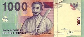
Thomas Matulessy, also known as Kapitan Pattimura or simply Pattimura, was a famous Ambonese soldier who became a symbol of both the Maluku and Indonesian struggle for independence, praised by President Sukarno and declared a national hero by President Suharto. He has several namesakes in both the Netherlands and in the Indonesian archipelago.
Iha may refer to:
The Sultanate of Ternate, previously also known as the Kingdom of Gapi is one of the oldest Muslim kingdoms in Indonesia besides the sultanates of Tidore, Jailolo, and Bacan.

The Sultanate of Tidore was a sultanate in Southeast Asia, centered on Tidore in the Maluku Islands. It was also known as Duko, its ruler carrying the title Kië ma-kolano. Tidore was a rival of the Sultanate of Ternate for control of the spice trade, and had an important historical role as binding the archipelagic civilizations of Indonesia to the Papuan world. According to extant historical records, in particular the genealogies of the kings of Ternate and Tidore, the inaugural Tidorese king was Sahjati or Muhammad Naqil whose enthronement is dated 1081 in local tradition. However, the accuracy of the tradition that Tidore emerged as a polity as early as the 11th century is considered debatable. Islam was only made the official state religion in the late 15th century through the ninth King of Tidore, Sultan Jamaluddin. He was influenced by the preachings of Syekh Mansur, originally from Arabia. In the 16th and 17th centuries, the sultans tended to ally with either Spain or Portugal in order to maintain their political role, but were finally drawn into the Dutch sphere of power in 1663. In spite of a period of anti-colonial rebellion in 1780–1810, the Dutch grip on the sultanate increased until decolonization in the 1940s. Meanwhile, Tidore's suzerainty over Raja Ampat and western Papua was acknowledged by the colonial state. In modern time, the sultanate has been revived as a cultural institution.
Moluccans are the Austronesian-speaking and Papuan-speaking ethnic groups indigenous to the Maluku Islands, Eastern Indonesia. The region was historically known as the Spice Islands, and today consists of two Indonesian provinces of Maluku and North Maluku. As such, "Moluccans" is used as a blanket term for the various ethnic and linguistic groups native to the islands.

The economic history of Indonesia is shaped by its geographic location, its natural resources, as well as its people that inhabited the archipelago that today formed the modern nation-state of the Republic of Indonesia. The foreign contact and international trade with foreign counterparts had also shaped and sealed the fate of Indonesian archipelago, as Indians, Chinese, Arabs, and eventually European traders reached the archipelago during the Age of Exploration and participated in the spice trade, war and conquest.

Ullath is one of 18 villages on the island of Saparua in the province of Maluku, Indonesia. Ullath situated on the southeastern peninsula of Saparua along with Siri-sori Amalatu, Siri-sori Amapatti, and Ouw. It is most known for its cloves, fish, and sago. The current raja is Abraham Nikijuluw.
Boano Island is an island in West Seram Regency, Maluku Province, Indonesia. It is located off the northern coast of the Hoamoal Peninsula at the western end of Seram Island, across the Boano Strait. The inhabitants speak the Boano, Luhu, as well as Indonesian and Ambonese Malay.
Sultan Mandar Syah was the 11th Sultan of Ternate who reigned from 1648 to 1675. Like his predecessors he was heavily dependent on the Dutch East India Company (VOC), and was forced to comply to Dutch demands to extirpate spice trees in his domains, ensuring Dutch monopoly of the profitable spice trade. During the Great Ambon War in the 1650s, Mandar Syah sided with the VOC but was nevertheless pushed to cede control over areas in Central Maluku. On the other hand, the Ternate-VOC alliance led to a large increase of Ternatan territory in the war with Makassar in 1667.