Kings Area Regional Transit

Last updated
Kings Area Regional Transit
Kings Area Regional Transit logo with strapline.svg
ParentKings County Area Public Transit Agency
Founded1980
Headquarters610 W 7th St
Locale Hanford, CA
Service type Bus service, Dial-a-Ride
Routes15
HubsHanford Transit Center
Annual ridership526,131 (2020) [1] [2]
Operator MV Transportation
Website Official website

Kings Area Regional Transit (KART, previously Kings Area Rural Transit) is the primary bus service serving residents and visitors to the cities of Avenal, Hanford, and Lemoore in Kings County, California. KART is the branded service operated by the Kings County Area Public Transit Agency (KCAPTA) since June 1980; KCAPTA has contracted with MV Transportation to provide operations and maintenance for KART. It provides both intracity routes within and intercity routes between those three cities; in addition, it provides routes serving rural communities within Kings County as well as commuter routes connecting to Fresno Area Express in Fresno and Visalia Transit in Visalia.

Contents

History

The Kings County Area Public Transit Agency is a joint powers agency that began operations in June 1980, formed by the four cities of Avenal, Cororan, Hanford, and Lemoore in partnership with the County of Kings. The City of Corcoran withdrew from KCAPTA two years later. [3] :3 On July 5, 2005, KCAPTA became a separate public entity; prior to that time, KCAPTA was part of the county government. [3] :13

KCAPTA also was responsible for operating vanpool programs in Kings County between 2001 and 2012. The vanpool programs were transferred to a new joint powers agency, CalVans in 2012. [3] :3

Structure

KCAPTA is governed by a five-person board of directors, consisting of two members appointed from the Kings County Board of Supervisors, and one member each from the three cities. [3] :3

Routes and services

KART operates ten local fixed routes (Routes 1–9 in Hanford and Route 20 in Lemoore) and five out-of-town routes (Routes 12, 13, 14, 15, and 17), connecting Hanford with Avenal, Corcoran, Laton, Visalia, and Fresno, respectively.

All routes start and end at the Hanford Transit Center, also known as the KART Transfer Center.

Kings Area Regional Transit fixed routes
No.Route namevia
(destinations)
Typical headway (minutes)Notes / Refs.
1Green LineDouty, Fargo, 11th
(Adventist Health Community Care-Hanford, Hanford High School, Hidden Valley Park, Kings Community Action Organization)
30 (M–F)
60 (Sa)
[4]
2Orange Line10th, Fargo, Douty
(Hanford Fraternal Hall, Hanford High School, Adventist Health Community Care-Hanford)
30 (M–F)
60 (Sa)
[5]
3Purple Line11th, Florinda, 914, Lacey
(Adventist Health Community Care-Hanford, Civic Park)
30 (M–F)
60 (Sa)
[6]
4Brown LineDouty, 3rd, 10th, Hanford-Armona
(Kings County Fairgrounds)
30 (M–F)
60 (Sa)
[7]
5Pink Line11th, Hume, 12th, Hanford-Armona
(Hanford DMV, Martin Luther King Jr. Elementary School)
30 (M–F)
60 (Sa)
[8]
6Blue LineLacey, Centennial, 7th
(Hanford West High School, Kings County Government Center, Target, Walmart, Hanford Mall, Adventist Health Community Care-Hanford)
30 (M–Sa) [9]
7Red Line11th, Grangeville, Centennial, Lacey
(YMCA, Hanford Mall, Kings County Government Center)
30 (M–F)
60 (Sa)
[10]
8Gray Line11th, Hanford-Armona, 10th, Houston
(Kings County Fairgrounds, Hanford DMV)
30 (M–F)
60 (Sa)
[11]
9Yellow Line7th, Lacey, 13th, Centennial
(Kings County Government Center, Courthouse, College of the Sequoias, Four Seasons Mobile Park, Hanford Mall)
30 (M–F)
60 (Sa)
[12]
12Avenal SR 198, SR 41, I-5
(Lemoore, Stratford, Kettleman City, Avenal)
105–180 (M–F)
315 (Sa)
[13]
13Corcoran SR 43
(Corcoran, Corcoran State Prison)
2 runs daily (M–F) [14]
14Laton14th, Excelsior, 1234
(Hardwick, Laton)
2 runs daily (M–F) [15]
15Visalia SR 198
(College of the Sequoias, Visalia Transit Center, Kaweah Delta Medical Center)
3 runs daily (M–F) [16]
17Fresno SR 99
(Laton, Selma, Fowler, Fresno [Fulton Street, Community Regional Medical Center, Veteran's Hospital, Kaiser Hospital], Valley Children's Hospital)
2 runs on Wed and Fri [17]
20Lemoore SR 198
(Armona, Lemoore)
30 (M–Sa) [18]

In addition to its fixed routes, KART operates paratransit services in Hanford, Lemoore, and Armona, providing service to and from destinations within 34 mi (1.2 km) of existing fixed route services. An additional fee is required for service to destinations up to 1+12 mi (2.4 km) of fixed route services. [19] Flex routes are provided in the same cities during weekdays. [20]

Fares

No change is provided on board the bus. [21]

TypeLocal RoutesOut-of-Town RoutesParatransit
Single tripRegular [lower-alpha 1] $1.25$1.75$2.50 [lower-alpha 2]
Discounted [lower-alpha 3] $0.60$0.85$2.50 [lower-alpha 4]
1-Day Pass$4.00$5.50$5.00 [lower-alpha 5]
10-Trip Card$10.00$14.00$25.00
30-Day PassRegular$50.00$60.00
Discounted [lower-alpha 3] $40.00$50.00
Notes
  1. Children 6 and under may ride free with an adult.
  2. A personal care assistant may ride free with a qualified individual.
  3. 1 2 Must have KART-issued ID card or Medicare card to qualify.
  4. Additional fare for each companion and/or child.
  5. "Premium Single Trip" for individuals between 34 and 1+12 mi (1.2 and 2.4 km) from the service area.

Fleet and facilities

Buses operate primarily from the KART Transfer Center; in addition, KCAPTA has an Administrative Office and KART Maintenance Facility. [3] :3 The existing Transfer Center has 10 bus bays; the Administrative Office is near the Transfer Center on 7th Street in downtown Hanford, and buses enter the site on 8th. [22] :6 Bus operators are provided by MV Transportation. [3] :3

The KART Transfer Center (504 W 7th St) is west of the railroad tracks, near the Hanford station serving Amtrak and the planned Cross Valley Corridor; KCAPTA have acquired 4 acres (1.6 ha) in the block bounded by 7th, Brown, 8th, and Harris, approximately 12 mi (0.80 km) to the east and plan to construct a new Hanford Transit Center and administration building there. The new transit center is scheduled to open in 2024. [23] KCAPTA officials presented preliminary designs by RRM Design Group, based in San Luis Obispo, to the Hanford City Council in February 2022. [24]

Related Research Articles

<span class="mw-page-title-main">Kings County, California</span> County in California, United States

Kings County is a county located in the U.S. state of California. The population was 152,486 at the 2020 census. The California Department of Finance estimated the county's population was 152,940 as of July 1, 2019. The county seat is Hanford.

<span class="mw-page-title-main">Armona, California</span> Census-designated place in California, United States

Armona is a census-designated place (CDP) in Kings County, California, United States. Armona is located 3.5 miles (5.6 km) west-southwest of Hanford, at an elevation of 239 feet (73 m). It is part of the Hanford–Corcoran Metropolitan Statistical Area. The population was 4,156 at the 2010 census. Armona's motto is "Small but Proud".

<span class="mw-page-title-main">Avenal, California</span> City in the state of California, United States

Avenal is a city in Kings County, California, United States. Avenal is located 35 miles (56 km) southwest of Hanford, at an elevation of 807 ft (246 m). It is part of the Hanford–Corcoran Metropolitan Statistical Area, which encompasses all of Kings County. In area, it is the fourth largest city in Kings County. The ZIP Code for this community is 93204, and telephone numbers use the sequence (559) 386-XXXX. The population was 15,505 in the 2010 census, which includes inmates at the Avenal State Prison, the first prison actively solicited by a community in the state of California. Many of the remaining residents largely either work at the prison or in the agriculture industry. The prison provides approximately 1,000 jobs to residents. The California Department of Finance estimated that Avenal's population was 13,496 on July 1, 2019. As of that date, Avenal State Prison held 4,165 inmates, which was about 32% of the total population of Avenal. Inmates are counted as city residents by both the United States Census and the California Department of Finance.

<span class="mw-page-title-main">Hanford, California</span> City in the state of California, United States

Hanford is a city and county seat of Kings County, California, located in the San Joaquin Valley region of the greater Central Valley. The population was 53,967 at the 2010 census.

<span class="mw-page-title-main">Kettleman City, California</span> Census-designated place in California, United States

Kettleman City is a census-designated place (CDP) in Kings County, California, United States. Kettleman City is located 28 miles (45 km) southwest of Hanford, 54 miles (88 km) south of Fresno, at an elevation of 253 feet (77 m), and sits only about 1/2 mile north of the 36th parallel north latitude. It is part of the Hanford–Corcoran Metropolitan Statistical Area. The population was 1,439 at the 2010 census, down from 1,499 at the 2000 census. When travelling between Los Angeles and either San Francisco or Sacramento via Interstate 5, Kettleman City is near the halfway point, and is thus a major stopping point for food and lodging.

<span class="mw-page-title-main">Lemoore, California</span> City in the state of California, United States

Lemoore is a city in Kings County, California, United States. Lemoore is located 7.5 miles (12 km) west-southwest of Hanford, at an elevation of 230 feet (70 m). It is part of the Hanford-Corcoran Metropolitan Statistical Area. The population was 24,531 at the 2010 Census. The California Department of Finance estimated that Lemoore's population was 26,725 on July 1, 2019.

<span class="mw-page-title-main">San Joaquin Valley</span> Area of the Central Valley in California

The San Joaquin Valley is the area of the Central Valley of the U.S. state of California that lies south of the Sacramento–San Joaquin River Delta and is drained by the San Joaquin River. It comprises seven counties of Northern and one of Southern California, including, in the north, all of San Joaquin and Kings counties, most of Stanislaus, Merced, and Fresno counties, and parts of Madera and Tulare counties, along with a majority of Kern County, in Southern California. Although the valley is predominantly rural, it has densely populated urban centers: Fresno, Bakersfield, Stockton, Modesto, Tulare, Visalia, Hanford, and Merced.

<span class="mw-page-title-main">Pace (transit)</span> Suburban bus service in the Chicago metropolitan area.

Pace is the suburban bus and regional paratransit division of the Regional Transportation Authority in the Chicago metropolitan area. It was created in 1983 by the RTA Act, which established the formula that provides funding to the Chicago Transit Authority (CTA), Metra, and Pace. The various agencies providing bus service in the Chicago suburbs were merged under the Suburban Bus Division, which rebranded as Pace in 1984. In 2013, Pace had 39.925 million riders. Pace is not an acronym, but a marketing name.

<span class="mw-page-title-main">Central California</span> Region of California in the United States

Central California is generally thought of as the middle third of the state, north of Southern California, which includes Los Angeles, and south of Northern California, which includes San Francisco. It includes the northern portion of the San Joaquin Valley, part of the Central Coast, the central hills of the California Coast Ranges and the foothills and mountain areas of the central Sierra Nevada.

<span class="mw-page-title-main">Area code 559</span> Telephone code in California

Area code 559 is a California telephone area code that was split from area code 209 on November 14, 1998.

<span class="mw-page-title-main">California State Route 198</span> Highway in California

State Route 198 is an east–west state highway in the U.S. state of California that runs from U.S. Route 101 south of King City to Sequoia National Park. It connects the California Central Coast to the mid–Central Valley through Hanford and Visalia, although the most developed portion is in the Central Valley itself. SR 198 intersects the major north–south routes in the Central Valley, including Interstate 5 (I-5), SR 33, and SR 99.

<span class="mw-page-title-main">Fresno Area Express</span> Public transit agency of Fresno, California

Fresno Area Express (FAX), is a public transportation operator in Fresno, California. The system has over 100 buses, 1,606 bus stops, and 18 routes as of August 2022. In 2021, the system had a ridership of 6,549,300, or about 23,300 per weekday as of the first quarter of 2022. FAX fixed routes run as far south as Malaga to Valley Children's Hospital in the north. Lines also run as far east as Fowler Avenue in Clovis, and as far west as Hayes Avenue near Highway 99 in western Fresno.

<span class="mw-page-title-main">Hanford station</span> Railway station in Hanford, California, US

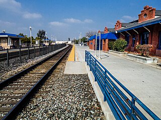
Hanford station is a train station in Hanford, California served by Amtrak. The station also services the larger city of Visalia, California, 20 miles (32 km) to the east.

The intercity transportation system in Visalia serves as a regional hub for passenger and freight traffic in the Sequoia Valley, composed of freeways, roads, and bus lines.

The Cross Valley Corridor is a proposed passenger rail service in the California Central Valley, connecting Visalia, Hanford, Porterville, and surrounding cities to each other and California High-Speed Rail's planned Kings–Tulare Regional Station.

<span class="mw-page-title-main">Porterville Transit</span> Transportation in California, United States

Porterville Transit (PT) was the primary bus agency serving residents and visitors to Porterville, the fourth-largest city in Tulare County, California. It was operated by the city and offered both fixed routes and dial-a-ride local service within Porterville, with all fixed routes operating out of a central transit center. Buses connecting Porterville's transit hub to nearby census-designated places were handled by Tulare County Area Transit (TCaT), including services to Tulare and Visalia, Springville, Terra Bella (80), and Poplar and Woodville (90).

Tulare County Area Transit (TCaT) was the county-operated bus agency providing service between cities and local community circulator routes in Tulare County, California; transit within the larger cities was provided by agencies operated by those communities, including Dinuba (DART), Porterville, Tulare (TIME), and Visalia ; connections are provided to Delano (DART) in neighboring Kern County.

<span class="mw-page-title-main">Visalia Transit</span> Transportation in California, United States

Visalia Transit (VT) is the primary bus agency serving residents and visitors to Visalia, California, the largest city and county seat of Tulare County, California. It is operated by the city through its contractor and offers both fixed routes and dial-a-ride local service within Visalia. In 2021, the system had a ridership of 539,300, or about 1,900 per weekday as of the first quarter of 2022.

<span class="mw-page-title-main">Tulare County Regional Transit Agency</span> Transportation in California, United States

The Tulare County Regional Transit Agency (TCRTA) is a joint powers agency formed by all the cities in Tulare County, California alongside the county government on August 17, 2020. It operates the public transportation systems within and connecting the respective member agencies, including the legacy systems Dinuba Area Regional Transit, Porterville Transit, Tulare InterModal Express, and Tulare County Area Transit. It is the largest single public transit agency in Tulare County.

<span class="mw-page-title-main">Fresno County Rural Transit Agency</span> Transportation in Fresno County, California, United States

Fresno County Rural Transit Agency (FCRTA) is the primary bus agency providing intra- and inter-city routes for smaller cities and unincorporated rural communities in Fresno County, California since 1979, including Coalinga, Firebaugh, Fowler, Huron, Kerman, Kingsburg, Mendota, Orange Cove, Reedley, Sanger, San Joaquin, and Selma. FCRTA riders may transfer to Fresno Area Express service within the county seat of Fresno, and FCRTA has additional transfer points connecting to neighboring agencies in Fresno, Kings, and Tulare counties, including Clovis Transit Stageline, Kings Area Regional Transit, and Dinuba Connection.

References

  1. "Kings County Area Public Transit Agency, 2020 Annual Agency Profile" (PDF). Federal Transit Administration. Retrieved 24 January 2022.
  2. "Transit Agency Profiles: Kings County Area Public Transit Agency, Region 9". Federal Transit Administration, United States Department of Transportation. Retrieved 7 March 2022.
  3. 1 2 3 4 5 6 Annual Financial Report for the Fiscal Years Ended June 30, 2021 and 2020 (PDF) (Report). Kings County Area Public Transit Agency. November 30, 2021. Retrieved 7 March 2022.
  4. "Hanford Route 1 Map and Schedule". Kings Area Regional Transit. Retrieved 7 March 2022.
  5. "Hanford Route 2 Map and Schedule". Kings Area Regional Transit. Retrieved 7 March 2022.
  6. "Hanford Route 3 Map and Schedule". Kings Area Regional Transit. Retrieved 7 March 2022.
  7. "Hanford Route 4 Map and Schedule". Kings Area Regional Transit. Retrieved 7 March 2022.
  8. "Hanford Route 5 Map and Schedule". Kings Area Regional Transit. Retrieved 7 March 2022.
  9. "Hanford Route 6 Map and Schedule". Kings Area Regional Transit. Retrieved 7 March 2022.
  10. "Hanford Route 7 Map and Schedule". Kings Area Regional Transit. Retrieved 7 March 2022.
  11. "Hanford Route 8 Map and Schedule". Kings Area Regional Transit. Retrieved 7 March 2022.
  12. "Hanford Route 9 Map and Schedule". Kings Area Regional Transit. Retrieved 7 March 2022.
  13. "Hanford-Avenal Route 12 Map and Schedule". Kings Area Regional Transit. Retrieved 7 March 2022.
  14. "Hanford-Corcoran Route 13 Map and Schedule". Kings Area Regional Transit. Retrieved 7 March 2022.
  15. "Hanford-Laton Route 14 Map and Schedule". Kings Area Regional Transit. Retrieved 7 March 2022.
  16. "Hanford-Visalia Route 15 Map and Schedule". Kings Area Regional Transit. Retrieved 7 March 2022.
  17. "Hanford-Fresno Route 17 Map and Schedule". Kings Area Regional Transit. Retrieved 7 March 2022.
  18. "Hanford-Lemoore Route 20 Map and Schedule". Kings Area Regional Transit. Retrieved 7 March 2022.
  19. "KART Paratransit Guide" (PDF). Kings Area Rural Transit. 2018–2019. Retrieved 7 March 2022.
  20. "Daytime Flex Routes" (PDF). Kings Area Regional Transit. Retrieved 7 March 2022.
  21. "Fares". Kings Area Regional Transit. Retrieved 7 March 2022.
  22. "6: Public Transit" (PDF). 2014 Kings County Regional Transportation Plan (Report). Kings County Association of Governments. July 30, 2014. Retrieved 7 March 2022.
  23. Cullor, Ravyn (June 22, 2021). "New transit center to bring face lift downtown, expand service". The Hanford Sentinel. Retrieved 7 March 2022.
  24. Gill, Eric (February 16, 2022). "$35M transit center design presented to Hanford council". The Hanford Sentinel. Retrieved 7 March 2022.