Kingsway, Glen Waverley

Last updated

Kingsway

Snedden Drive

Kingsway Glen Waverley.jpg
Kingsway in 2017
Kingsway, Glen Waverley
Australia Victoria metropolitan Melbourne location map.svg
Red pog.svg
North end
Red pog.svg
South end
Coordinates
General information
TypeStreet
Length1.2 km (0.7 mi) [1]
Major junctions
North endAustralian state route 24.svgHigh Street Road
Glen Waverley, Melbourne
 
  • O'Sullivan Road
  • Railway Parade North
  • Coleman Parade
South endAustralian state route 40.svg Springvale Road
Glen Waverley, Melbourne
Location(s)
LGA(s) City of Monash
Suburb(s) Glen Waverley

Kingsway is a shopping, dining and entertainment precinct at the town centre of Glen Waverley, a southeastern suburb of Melbourne, Victoria, Australia. It starts off at the northern end from High Street, and runs north-south parallel to Springvale Road before curving east at its southern end to join the latter as a T-intersection.

Contents

Along Kingsway are two major shopping centres, The Glen Shopping Centre [2] at its northern end, which offers more than 3,500 parking spaces; [3] and Century City Walk at its southern end, which contains a Village Cinemas multiplex, other entertainment retailers (such as Strike Bowling Bar), a tavern and various eateries, as well as Novotel and Ibis. [4] The Glen Waverley railway station is located just on the west of its middle section, and the City of Monash City Council and Civic Centre, the Glen Waverley Public Library, Uniting Church and Centrelink Office are also located at Kingsway.

Retailers

Kingsway has a range of shopping, dining and entertainment retailers, but is best known for its eateries.[ citation needed ] Retailers include Asian influenced and other restaurants and cafes, travel agencies, clothing stores, hairdressers, grocery stores, gift shops, a newsagency, after school tuition centres, pharmacies and mobile phone dealers. Larger retailers include Dan Murphy's, Village Cinemas and Intencity. Other major retailers such as Woolworths, Coles, David Jones, Target and Lincraft are located inside The Glen Shopping Centre. [5]

Service providers include Real Estate agents, four bank branches and dry cleaners. Other service providers are located within The Glen Shopping Centre. [5]

Hotels

Nearby hotels include Novotel, Hotel Ibis, Waverley International Hotel and Quest Serviced Apartments.

Public transport

The Kingsway shopping precinct is served by buses and trains. The Glen Waverley railway station is the terminal station for the Glen Waverley railway line. The bus interchange north of the station on Railway Parade North acts as a hub for transport activity in the Glen Waverley area.

Bus

RoutesOperatorZone(s)To / FromVia
623 [6] CDC Melbourne 1, 2Glen Waverley / St. KildaMount Waverley / Chadstone / Carnegie
734 [7] Ventura Bus Lines 1, 2Glen Iris / Glen WaverleyAshburton / Ashwood / Wesley College
736 [8] Ventura Bus Lines 2Mitcham / BlackburnVermont South / Glen Waverley / Forest Hill
737 [9] Ventura Bus Lines 2Croydon / Monash UniversityBoronia / Knox City SC / Glen Waverley
742 [10] Ventura Bus Lines 1, 2Eastland SC / Chadstone SCVermont South / Glen Waverley / Oakleigh
753 [11] Ventura Bus Lines 2Glen Waverley / BayswaterWheelers Hill / Knoxfield / Boronia
754 [12] Ventura Bus Lines 2Rowville / Glen WaverleyCaulfield Grammar / Wheelers Hill
850 [13] Grenda's Bus Services 2Dandenong / Glen WaverleyBrandon Park / Mulgrave

Redevelopment

In January 2006, the Monash City Council agreed in principle to the redevelopment of the transport hub and began to negotiate with VicTrack Access to develop a mixed-use multi storey building located in the forecourt area of the Glen Waverley Railway Station. [14] This development is part of the Victorian Government's Melbourne 2030 plan. The redevelopment will include a multi-deck car park, multi-story residential and commercial buildings and a pedestrian bridge or underground crossing linking both buildings. The Glen Waverley Railway Station is also planned to be redeveloped. The first stage of redevelopment, entailing preliminary roadworks is due for completion in October 2009. [15] The Kingsway Realignment Project is jointly funded by Monash City Council, the Department of Planning and Community Development's 'Creating Better Places Program' and VicTrack. [15]

Festivals

Kingsway hosted Glen Waverley's inaugural Food and Wine Festival in November 2009. [16] The festival was primarily funded through the Monash City Council having approved $80,000 in funding in 2008, [16] and included many Kingsway retailers and Victorian wineries. [16] The streets surrounding Kingsway was closed off to traffic.

An inaugural Chinese New Year Lantern Festival was held in February 2009. [17]

Major intersections

LGALocationkmmiDestinationsNotes
Australian state route 24.svg High Street Road (Metro Route 24) – City, Knoxfield
O'Sullivan Road
Railway Parade North
Coleman Parade
Australian state route 40.svg Springvale Road (Metro Route 40)  Springvale, Glen Waverley

See also

Australia road sign W5-29.svg   Australian Roadsportal

Related Research Articles

<span class="mw-page-title-main">Glen Iris railway station</span> Railway station in Melbourne, Australia

Glen Iris railway station is a commuter railway station in Glen Iris, a suburb of Melbourne, Victoria, Australia. The station opened on 24 March 1890 as part of the branch line from Burnley to Waverley Road station. The station consists of one island platform accessed by a pedestrian underpass. There is one principal station building located the platform. The single-story building, constructed in 1975 as part of the station's rebuilding, acts as a shelter and has toilet facilities. The station is only partially accessible due to steep access ramps.

<span class="mw-page-title-main">Glen Waverley, Victoria</span> Suburb of Melbourne, Victoria, Australia

Glen Waverley is a suburb in Melbourne, Victoria, Australia, 19 km (12 mi) south-east of Melbourne's Central Business District, located within the City of Monash local government area. Glen Waverley recorded a population of 42,642 at the 2021 census.

<span class="mw-page-title-main">Oakleigh, Victoria</span> Suburb of Melbourne, Victoria, Australia

Oakleigh is a suburb in Melbourne, Victoria, Australia 14 km south-east of Melbourne's Central Business District, located within the City of Monash local government area. Oakleigh recorded a population of 8,442 at the 2021 census.

<span class="mw-page-title-main">Caulfield, Victoria</span> Suburb of Melbourne, Victoria, Australia

Caulfield is a suburb in Melbourne, Victoria, Australia, 10 kilometres (6.2 mi) south-east of Melbourne's Central Business District, located within the City of Glen Eira local government area. Caulfield recorded a population of 5,748 at the 2021 census.

<span class="mw-page-title-main">Box Hill railway station, Melbourne</span> Railway station in Box Hill, Melbourne, Victoria, Australia

Box Hill railway station is located on the Lilydale and Belgrave lines in Victoria, Australia. It serves the eastern Melbourne suburb of Box Hill, and opened on 1 December 1882.

<span class="mw-page-title-main">Carnegie railway station</span> Railway station in Melbourne, Australia

Carnegie railway station is a commuter railway station located in the suburb of Carnegie, in the southeastern suburbs of Melbourne, Victoria, Australia. The station originally opened in 1879 as Rosstown. The station received its current name in 1909 alongside the renaming of the suburb. The station consists of a single island platform connected to the station concourse on Koornang Road via escalators, lifts and a staircase.

<span class="mw-page-title-main">Oakleigh railway station</span> Railway station in Melbourne, Australia

Oakleigh railway station is a commuter railway station in the suburb of Oakleigh in the south-east of Melbourne, Victoria, Australia. The station opened in 1877 as the up end of the Gippsland line, with the station being electrified in 1922. The station consists of two sides that are connected to each other via the adjacent roads, and both platforms are connected to each other via a pedestrian subway.

<span class="mw-page-title-main">Dandenong railway station</span> Railway station in Melbourne, Australia

Dandenong railway station is the junction for the Pakenham and Cranbourne lines in Victoria, Australia. It serves the south-eastern Melbourne suburb of the same name, and opened on 8 October 1877.

<span class="mw-page-title-main">Darling railway station</span> Railway station in Melbourne, Australia

Darling railway station is a commuter railway station in Malvern East, a suburb of Melbourne, Australia. The station opened on 24 March 1890 as part of the branch line from Burnley to Waverley Road station. The station consists of two side platforms accessed by a pedestrian bridge. There are two principal station buildings with one located on each platform. These buildings are both single story and act as customer service, staff, and waiting room facilities. These buildings were provided in 1979 as part of the station rebuild. The station is fully accessible and comply with DDA accessibility guidelines.

<span class="mw-page-title-main">East Malvern railway station</span> Railway station in Melbourne, Australia

East Malvern railway station is a commuter railway station on the Glen Waverley line, serving Malvern East, a suburb of Melbourne, Victoria, Australia. The station, originally called Karnak, opened as Eastmalvern on 3 February 1929. It was renamed East Malvern on 29 February 1972.

<span class="mw-page-title-main">Mount Waverley railway station</span> Railway station in Melbourne, Australia

Mount Waverley railway station is a commuter railway station in the suburb of Mount Waverley in the south east of Melbourne, Victoria, Australia, and is part of the Glen Waverley line on Melbourne's suburban rail network. The station opened in 1930 as a part of the extension from East Malvern to Glen Waverley. The station consists of two side which are connected to each other via the adjacent roads, additionally both platforms are connected to each other via a pedestrian subway. Additionally the station is served by bus routes 623 and 733. The station is appromixately 18 kilometres (11 mi) or around a 30-minute train ride away from Flinders Street.

<span class="mw-page-title-main">Syndal railway station</span> Railway station in Melbourne, Australia

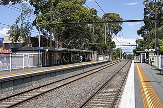
Syndal railway station is a commuter railway station in the suburb of Glen Waverley in the south east of Melbourne, Victoria, Australia. The station opened in 1930 as a part of the extension from East Malvern to Glen Waverley. The station consists of a single island platforms which is connected to Hunter Street and Coleman Parade via a pedestrian subway.

<span class="mw-page-title-main">Glen Waverley railway station</span> Commuter railway station in Melbourne, Australia

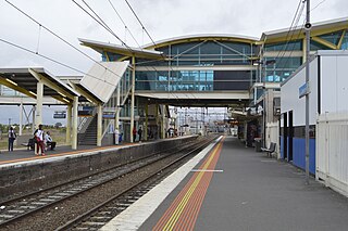
Glen Waverley railway station is a commuter railway station located in the suburb of Glen Waverley in the south-east of Melbourne, Victoria, Australia. The station originally opened in 1930 as part of the line's extension from East Malvern. The station consists of a single island platform that is connected to Kingsway via a ramp on the station's eastern end.

<span class="mw-page-title-main">Croydon railway station, Melbourne</span> Railway station in Melbourne, Australia

Croydon railway station is a commuter railway station on the Lilydale line, serving the eastern Melbourne suburb of Croydon, Victoria, Australia. Croydon is a premium status ground structure station featuring two side platforms. It opened on 1 December 1882 as Warrandyte before being renamed Croydon on 1 August 1884.

<span class="mw-page-title-main">Bayswater railway station, Melbourne</span> Melbourne railway station

Bayswater railway station is located on the Belgrave line in Victoria, Australia. It serves the eastern Melbourne suburb of Bayswater, and opened on 4 December 1889.

<span class="mw-page-title-main">Boronia railway station</span> Railway station in Melbourne, Australia

Boronia railway station is located on the Belgrave line in Victoria, Australia. It serves the eastern Melbourne suburb of Boronia, and it opened on 19 June 1920.

<span class="mw-page-title-main">Proposed Melbourne rail extensions</span> Extensions to the Melbourne rail network

Proposals for expansion of the Melbourne rail network are commonly presented by political parties, government agencies, industry organisations and public transport advocacy groups. The extensions proposed take a variety of forms: electrification of existing routes to incorporate them into the suburban rail system; reconstruction of former passenger rail lines along pre-existing easements; entirely new routes intended to serve new areas with heavy rail or provide alternative routes in congested areas; or track amplification along existing routes to provide segregation of services. Other proposals are for the construction of new or relocated stations on existing lines, to provide improved access to public transport services.

<span class="mw-page-title-main">Chadstone Shopping Centre</span> Shopping mall in Victoria, Australia

Chadstone Shopping Centre is a shopping centre located in the south-eastern Melbourne suburb of Malvern East. Chadstone Shopping Centre is the biggest shopping centre in Australia by both area and number of stores and one of the biggest in the Southern Hemisphere. The centre opened on 3 October 1960 and was the first self-contained regional shopping centre in Melbourne.

<span class="mw-page-title-main">Scotchmans Creek Trail</span>

The Scotchmans Creek Trail is a shared use path for cyclists and pedestrians, which follows Scotchmans Creek through the eastern suburbs of Melbourne, Victoria, Australia.

Numerous proposals have been made for improvements to the Melbourne tram network, the largest such network in the world. Nearly all of these have been for track extensions of existing lines to connect with nearby railway station or to service new areas and suburbs.

References

  1. Google (28 May 2022). "Kingsway" (Map). Google Maps . Google. Retrieved 28 May 2022.
  2. Centro Properties Group – Property Overview, accessed 10 June 09
  3. The Glen – Parking
  4. Century City Walk Website, accessed 10 June 09
  5. 1 2 Archived 12 June 2009 at the Wayback Machine Centro The Glen Store Listing, accessed 10 June 09
  6. "623 Glen Waverley - St Kilda via Mount Waverley & Chadstone & Carnegie". Public Transport Victoria.
  7. "734 Glen Iris - Glen Waverley". Public Transport Victoria.
  8. "736 Mitcham - Blackburn via Vermont South & Glen Waverley & Forest Hill". Public Transport Victoria.
  9. "737 Croydon - Monash University via Boronia & Knox City Shopping Centre & Glen Waverley". Public Transport Victoria.
  10. "742 Eastland - Chadstone via Vermont South & Glen Waverley & Oakleigh". Public Transport Victoria.
  11. "753 Glen Waverley - Bayswater via Wheelers Hill & Knoxfield & Boronia". Public Transport Victoria.
  12. "754 Rowville - Glen Waverley via Caulfield Grammar & Wheelers Hill". Public Transport Victoria.
  13. "850 Dandenong - Glen Waverley via Mulgrave & Brandon Park". Public Transport Victoria.
  14. Archived 17 October 2009 at the Wayback Machine Council Meeting – Report (Development Of Hub Precinct, Glen Waverley Activity Centre), accessed 8 June 09
  15. 1 2 Archived 12 June 2009 at the Wayback Machine Council Media Release (Kingsway Realignment Works Now Underway), accessed 8 June 09
  16. 1 2 3 Archived 19 February 2011 at the Wayback Machine Waverley Leader: Food fest, culture on menu for Glen Waverley (21 October 2008), accessed 8 June 09
  17. Archived 31 December 2012 at archive.today Monash Leader: Glen Waverley swinging to a Chinese beat (28 October 2008), accessed 8 June 09

Sources

37°52′53″S145°9′49″E / 37.88139°S 145.16361°E / -37.88139; 145.16361