Knight Street Bridge

Last updated
Knight Street Bridge
Knight Street Bridge.jpg
Coordinates 49°12′15″N123°04′39″W / 49.204084°N 123.077517°W / 49.204084; -123.077517
Carries4–6 lanes of Knight Street, and pedestrians/bicycles
Crosses North Arm Fraser River
Locale Richmond
Vancouver
Owner TransLink
Preceded byFraser Street Bridge
Characteristics
Design girder bridge
Total length1436 m
History
Construction start1969
OpenedJanuary 15, 1974
Location
Knight Street Bridge

The Knight Street Bridge is a crossing over the north arm of the Fraser River, the Canadian National Railway (CNR) line, and several roads, in Metro Vancouver.

Contents

History

Infrastructure

The 1929 Vancouver Major Streets Plan designated the Clark-Knight corridor as a six-lane arterial road. The upgrade delayed for decades, Knight St. was never a streetcar route, and experienced less commercial and lower intensity development than nearby arterials. [1] A late 1950s metropolitan highway planning committee recommendation included a proposed 1970s crossing in the vicinity, to relieve the Oak Street Bridge. [2]

Constructed 1969–1974, the structure was the second cast-in-place segmental cantilever bridge built in North America, the first being Quebec in 1964. For many years, the 109.7-metre (360 ft) main span held the world record for this design. [3] Each drop-in span, which joins the two separate parallel cantilever spans from the main piers, is an arched post-tensioned concrete girder, resting on rubber bearings at each end. [4] Like Knight Street, the bridge was named after Robert Knight, a property owner in South Vancouver in the late 19th and early 20th centuries. [5]

During the planning stage, the project was known as the Fraser Street Bridge Replacement. At the official opening ceremony in January 1974, Graham Lea, provincial Minister of Highways, cut the ribbon. On hand were Gil Blair, mayor of Richmond, and Art Phillips, mayor of Vancouver. [6] Totalling about $15M, including $3M for roadways, the province funded the scheme. [7] On formation in 1999, TransLink assumed ownership and maintenance responsibilities. [8]

The configuration comprises an overpass of Marine Drive, the 238-metre (781 ft) Knight Street Bridge North, and the 1,198-metre (3,930 ft) Knight Street Bridge South. The six-lane medium-level bridge reduces to four lanes over Mitchell Island, the outside lanes becoming the off and on ramps for the island. The electrically heated deck minimizes winter de-icing. [9] On the underside of the deck, the western spans carry a maintenance walkway, above which are a water pipe, gas pipe, and electrical lines. The navigational clearance is 19–23 metres (62–75 ft) at the apex, depending upon the tide. [4]

Upgrading Knight St., and eliminating the load weight restrictions associated with the previous structure, this VancouverRichmond link eased congestion, [10] and connected to Highway 99, and since 1989, Highway 91. Averaging over 100,000 vehicle crossings daily, the bridge is the second busiest in the Lower Mainland. [11] Cyclists are legally required to ride on the sidewalks. [12]

Maintenance, upgrades and incidents

On January 15, 2000 the boom of a mobile crane transported on a barge named T.L. Sharpe, towed by the Sea Cap XII, struck the underside of the Knight Street Bridge at 1:45 PM, damaging the bridge and the fixtures secured underneath its deck. The impact caused the boom to bend and the crane to slide off the barge and sink, and the bridge was closed to traffic for about 48 hours. [4] Water supply to Mitchell Island via the bridge was shut down for 25 days, and an emergency bypass water supply from Vancouver was installed. [13] The incident prompted the City of Richmond to install a second water main to Mitchell Island in 2002. [14]

Knight Street Bridge, northward. Richmond in foreground Knight Street Bridge and Fraser River, Richmond - panoramio.jpg
Knight Street Bridge, northward. Richmond in foreground

In 2011, the bridge underwent a seismic retrofit of three abutments, which were vulnerable to settlement or collapse from movements during soil liquefaction. The subsurface conditions comprise dense till-like soils for the north bridge, but potentially liquefiable deltaic sediments for the south bridge. The north abutments and piers rest upon spread footings, whereas the south ones rest upon timber and steel-pipe piles. To densify the ground, 105 injection boreholes were drilled to a depth of 12.3 metres (40 ft) around one abutment, and filled at pressure with a low mobility grout up to the surface. Timber compaction piles were used for densification in other areas. Steel-pipe piles were installed at a pier adjacent to the riverbank. [15]

Ranking first in Vancouver, the bridge was the scene of more than 2,500 car accidents during 2013–2017, of which nearly half resulted in injuries or fatalities. [16] The Marine Dr. on and off ramps have rated among Canada's most dangerous intersections. [17] In 2017, the city made design and signalling changes to enhance safety, which included a new turn bay for westbound vehicles on SE Marine Dr. turning north, and a new shared walking and cycling path. [18]

During early 2020, the bridge underwent extensive rehabilitation that required overnight single lane closures in each direction. The work included lighting upgrades, pier repairs, and the replacement of crash cushions, signage, and bearing and expansion joints. [11] Rehabilitation works also took place in 2023, including bearing replacements, milling and repaving the top layer of concrete deck with polyester polymer concrete (PPC) overlay to prevent future corrosion, pier patch repair expansion joint replacement and railing replacement (https://www.translink.ca/plans-and-projects/projects/maintenance-and-upgrade-program/bridge-projects).

Land developments

Formerly, transport planning had not been coordinated with land use planning. However, the establishment of the Agricultural Land Reserve in 1973 encouraged the development of the Surrey plateau, and reduced encroachment upon the agricultural lowland of Richmond. [19] If land use had been determined by market forces alone, development along the Knight St. extension south of the bridge would have created the largest industrial park in region. [20] The initial zoning proposal was for a broader footprint south to Cambie Rd., but the final version provided the present narrower corridor south to Westminster Hwy. [21]

Transit

In 2014, improvements to the Mitchell Island interchange included extended loading bays to aid bus manoeuvering, widening passenger walkways, installing over 60 metres (197 ft) of safety barriers, new traffic islands, and new signage. [22]

See also


Footnotes

  1. "Clark-Knight Corridor Whole Route Analysis". www.vancouver.ca. 2003.
  2. Levesque 1974, p. 6.
  3. "Knight Street Bridge". www.linkedin.com.
  4. 1 2 3 "Marine Investigation Report M00W0005". www.tsb.gc.ca. 2000.
  5. Walker, Elizabeth (1999). Street Names of Vancouver. Vancouver Historical Society. p. 67. ISBN   0-9692378-7-1.
  6. Dawe 1996, pp. 53–54.
  7. Dawe 1996, p. 55.
  8. "Buzzer blog, 17 May 2016". www.translink.ca. TransLink.
  9. "Vancouver history". www.vancouverhistory.ca. 1974.
  10. Levesque 1974, p. 4.
  11. 1 2 "TransLink maintenance program". www.translink.ca.
  12. "Cycling: Bridge Crossings". www.richmond.ca.
  13. "City of Richmond: Report to Committee re: Knight Street Bridge Watermain" (PDF). www.richmond.ca. Archived from the original (PDF) on 2019-12-06. Retrieved 2011-01-25.
  14. "City of Richmond: 2002 Annual Report" (PDF). www.richmond.ca. p. 7. Archived from the original (PDF) on 2019-11-15. Retrieved 2020-03-29.
  15. "Seismic Assessment and Retrofit of the Knight Street Bridge". www.klohn.com.;
    "Seismic Retrofit of the Knight Street Bridge". www.klohn.com.;
    "Seismic Retrofit of the Knight Street Bridge". www.southwestcontracting.ca.
  16. "Top 5 most dangerous intersections in Vancouver, B.C." www.callkleinlawyers.com.
  17. "Vancouver history, Knight Street Bridge". www.miss604.com. Archived from the original on 2013-08-19. Retrieved 2020-03-29.;
    "Canada's most dangerous intersections". www.markhammitsubishi.ca.
  18. "The Georgia Straight, 21 Jul 2017". www.straight.com.
  19. Levesque 1974, p. 8.
  20. Levesque 1974, p. 89.
  21. Levesque 1974, pp. 100 & 102.
  22. "Buzzer blog, 3 Jan 2014". www.translink.ca. TransLink.


Related Research Articles

<span class="mw-page-title-main">Richmond–San Rafael Bridge</span> Bridge crossing the San Francisco Bay

The Richmond–San Rafael Bridge is the northernmost of the east–west crossings of California's San Francisco Bay, carrying Interstate 580 from Richmond on the east to San Rafael on the west. It opened in 1956, replacing ferry service by the Richmond–San Rafael Ferry Company, and was officially renamed in 1981 to honor California State Senator John F. McCarthy, who championed the bridge's creation.

<span class="mw-page-title-main">Carquinez Bridge</span> Pair of bridges in the San Francisco Bay between Crockett and Vallejo, California, USA

The Carquinez Bridge is a pair of parallel bridges spanning the Carquinez Strait at the northeastern end of San Francisco Bay. They form the part of Interstate 80 between Crockett and Vallejo, California, United States.

<span class="mw-page-title-main">George Massey Tunnel</span> Tunnel beneath the Fraser River in British Columbia

The George Massey Tunnel is a highway traffic tunnel in the Metro Vancouver region of southwestern British Columbia. It is located approximately 20 km (12.4 mi) south of the city centre of Vancouver, British Columbia, and approximately 30 km (18.6 mi) north of the Canada–United States border at Blaine, Washington.

<span class="mw-page-title-main">Westham Island Bridge</span> Bridge in Delta, British Columbia, Canada

The Westham Island Bridge, which is a single-lane, wood-deck truss bridge over Canoe Pass near the mouth of the Fraser River, connects Westham Island with the Delta mainland, in Metro Vancouver.

<span class="mw-page-title-main">Arthur Laing Bridge</span> Bridge in Richmond, Vancouver

The Arthur Laing Bridge is a crossing over the north arm of the Fraser River, and several minor roads, in Metro Vancouver.

<span class="mw-page-title-main">Oak Street Bridge</span> Bridge in Vancouver-Richmond

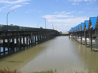
The Oak Street Bridge is a crossing over the north arm of the Fraser River, the Canada Line, and several roads, in Metro Vancouver.

<span class="mw-page-title-main">Moray Bridge</span> Bridge in Richmond

The Moray Bridge, also known as the Moray Channel Bridge, and formerly the Middle Arm Bridge, is a crossing over the middle arm of the Fraser River in Metro Vancouver. Richard Moody, who would name geographical features, such as this channel, after acquaintances, honoured Jonathan Moray (1824–84), a sergeant in the Corps of Royal Engineers, and later the New Westminster police chief.

<span class="mw-page-title-main">Sea Island Connector</span> Bridge in Richmond, BC

The Sea Island Connector, is a crossing over the middle arm of the Fraser River in Metro Vancouver.

<span class="mw-page-title-main">Dinsmore Bridge</span> Bridge in Richmond

The Dinsmore Bridge is a crossing over the middle arm of the Fraser River, and a former section of River Rd., in Metro Vancouver.

<span class="mw-page-title-main">No. 2 Road Bridge</span> Bridge across the Middle Arm of the Fraser River in British Columbia, Canada

The No. 2 Road Bridge is a crossing over the middle arm of the Fraser River, and River Rd., in Metro Vancouver.

<span class="mw-page-title-main">Marpole Bridge</span> Bridge in Marpole–Richmond

The Marpole CP Rail Bridge is a partially dismantled crossing over the north arm of the Fraser River, and River Dr., in Metro Vancouver.

<span class="mw-page-title-main">North Arm Bridge</span> Bridge in Metro Vancouver, British Columbia, Canada

The North Arm Bridge is an extradosed bridge in Metro Vancouver, British Columbia, Canada. It spans the north arm of the Fraser River, linking Vancouver to Richmond. It is used by trains on the Canada Line, which opened in August 2009.

<span class="mw-page-title-main">Mission Bridge</span> Bridge on Highway 11 in southwestern British Columbia

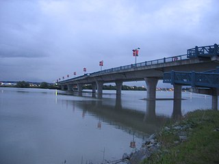
The Mission Bridge is a steel and concrete girder bridge across the Fraser River in the Fraser Valley region of southwestern British Columbia, Canada. Linking the City Of Mission and the City of Abbotsford, the four-lane structure carries BC Highway 11.

The Agassiz–Rosedale Bridge is a cantilever truss bridge across the Fraser River in the Fraser Valley region of southwestern British Columbia. Linking Agassiz with the south shore, the two-lane bridge carrying BC Highway 9 is by road about 36 kilometres (22 mi) west of Hope, 119 kilometres (74 mi) east of Vancouver, and 51 kilometres (32 mi) east of Abbotsford.

The Alexandra Bridge is a steel arch bridge across the Fraser River in the lower Fraser Canyon area of southwestern British Columbia, Canada. The two-lane crossing, carrying BC Highway 1, is by road about 44 kilometres (27 mi) north of Hope and 66 kilometres (41 mi) south of Lytton.

<span class="mw-page-title-main">Bailey Bridge (Walton on Trent)</span> Crossing of the River Trent at Walton-on-Trent in England

The Bailey Bridge is a crossing of the River Trent at Walton-on-Trent on the border of Derbyshire and Staffordshire in England. The bridge is only one lane wide with access controlled by a tidal flow system controlled by signals at either end of the bridge. A separate footbridge is attached to the northern side of the structure.

<span class="mw-page-title-main">Champlain Bridge (Montreal, 2019–present)</span> Bridge over the Saint Lawrence River in Montreal, Canada

The Samuel De Champlain Bridge, colloquially known as the Champlain Bridge, is a cable-stayed bridge design by architect Poul Ove Jensen and built to replace the original Champlain Bridge over the Saint Lawrence River in Quebec, between Nuns' Island in the borough of Verdun in Montreal and the suburban city of Brossard on the South Shore. A second, connected bridge links Nuns' Island to the main Island of Montreal. The bridge is the busiest bridge in the country with more cars flowing into it than any other bridge.

The Marpole Bridge (1889–1957), a.k.a. Eburne Bridge, North Arm Bridge, Sea Island Bridge, or Middle Arm Bridge, was consecutive crossings over the north and middle arms of the Fraser River in Metro Vancouver.

<span class="mw-page-title-main">Fraser Street Bridge (1894)</span> Bridge in Sunset-Richmond

The Fraser St. Bridge (1894–1974), also known as the Fraser Ave. Bridge, North Arm Bridge, No. 5 Rd. Bridge, or Twigg Island Bridge, was a crossing over the north arm of the Fraser River in Metro Vancouver.

References