Knik River is a census-designated place (CDP) in Matanuska-Susitna Borough in the U.S. state of Alaska. Located 15 miles southeast from Palmer along the Knik River, it is part of the Anchorage, Alaska Metropolitan Statistical Area. The population was 792 at the 2020 census, up from 744 in 2010.

Point MacKenzie is a census-designated place (CDP) in Matanuska-Susitna Borough, Alaska, United States. It is part of the Anchorage, Alaska Metropolitan Statistical Area. At the 2020 census the population was 1,852, up from 529 in 2010.

Susitna is a census-designated place (CDP) in Matanuska-Susitna Borough, Alaska, United States. It is part of the Anchorage Metropolitan Area. As of the 2020 census, the population of the CDP was 11.

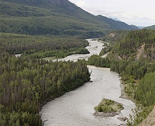
The Susitna River is a 313-mile (504 km) long river in the Southcentral Alaska. It is the 15th largest river in the United States, ranked by average discharge volume at its mouth. The river stretches from the Susitna Glacier to Cook Inlet's Knik Arm.

Eklutna is a native village within the Municipality of Anchorage in the U.S. state of Alaska. The Tribal Council estimates the population at 70; many tribal members live in the surrounding communities.

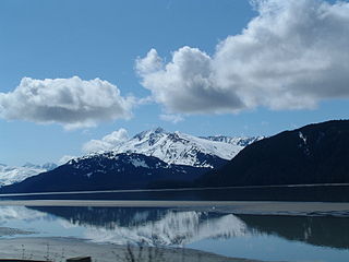
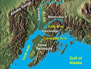
Cook Inlet stretches 180 miles (290 km) from the Gulf of Alaska to Anchorage in south-central Alaska. Cook Inlet branches into the Knik Arm and Turnagain Arm at its northern end, almost surrounding Anchorage. On its southern end, it merges with Shelikof Strait, Stevenson Entrance, Kennedy Entrance and Chugach Passage.
The Matanuska River (Dena'ina: Ch'atanhtnu) is a 75-mile (121 km) long river in Southcentral Alaska, United States. The river drains a broad valley south of the Alaska Range eponymously known as the Matanuska Valley.
Turnagain Arm is a waterway into the northwestern part of the Gulf of Alaska. It is one of two narrow branches at the north end of Cook Inlet, the other being Knik Arm. Turnagain is subject to climate extremes and large tide ranges.

Chugiak is an unincorporated community in the Municipality of Anchorage in the U.S. state of Alaska, situated approximately 20 miles (32 km) northeast of downtown Anchorage.
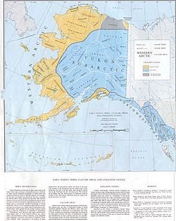
The Denaʼina, or formerly Tanaina, are an Alaska Native Athabaskan people of the Athabaskan-speaking ethnolinguistic group. They are the original inhabitants of the south central Alaska region ranging from Seldovia in the south to Chickaloon in the northeast, Talkeetna in the north, Lime Village in the Northwest and Pedro Bay in the Southwest. The Denaʼina homeland is more than 41,000 square miles in area. They arrived in the Southcentral Alaska sometime between 1,000 and 1,500 years ago. They were the only Alaskan Athabaskan group to live on the coast. Denaʼina culture is a hunter-gatherer culture and have a matrilineal system. The Iditarod Trail's antecedents were the native trails of the Denaʼina and Deg Hitʼan Athabaskan Indians and the Inupiaq Eskimos.
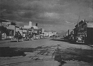
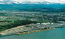
After congress approved the completion of the Alaska Railroad from Seward to Fairbanks in 1914, it was decided that a new town should be built as a port and rail hub along the route. The decision was made to develop a site near Ship Creek on Cook Inlet. Survey parties visited the area in 1914 and researched possible routes for the rails and options for siting the new town. Anchorage was originally settled as a tent city near the mouth of Ship Creek in 1915, and a planned townsite was platted alongside the bluff to the south. Anchorage was mostly a company town for the Alaska Railroad for its first several decades of existence.
The Knik Arm Bridge is a dormant proposal for a 1.74-mile (2.80 km) bridge across Cook Inlet's Knik Arm to link the two fastest growing parts of Alaska – Anchorage and the Matanuska-Susitna Borough.
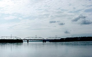
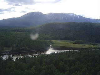
The Knik River (Dena'ina: Skitnu) is a 25-mile-long (40 km) river in the U.S. state of Alaska. Its source is at Knik Glacier, from which it flows northwest and west and empties into the head of Cook Inlet's Knik Arm, near the mouth of the Matanuska River. It is bridged twice where the Old Glenn Highway crosses it near the Butte, and also bridged on the Hayflats.

Mount Susitna, also known as Sleeping Lady, (Dena'ina: Dghelishla) is a 4,396-foot (1,340 m) mountain in the U.S. state of Alaska. It is located on the west bank of the lower Susitna River, about 33 miles (53 km) northwest of Anchorage, Alaska. The mountain is a prominent landmark in the Anchorage area and can be seen across the Knik Arm of the Cook Inlet from most of the city, especially at higher elevations.
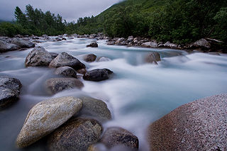
Little Susitna River (Dena'ina: Tsałtastnu) heads at Mint Glacier on Montana Peak, in Talkeetna Mountains at 61°51′30″N149°03′30″W, flows southwest to Cook Inlet, 13 miles (21 km) west of Anchorage, Alaska Cook Inlet Low.
Dinglishna Hill is a hill located East of Mount Susitna, in the Matanuska-Susitna Valley of South Central Alaska.
Alexander is an unincorporated community in Matanuska-Susitna Borough, Alaska, United States. An Alaska Native community with an Alaska Native Village Corporation, it lies on the Susitna River delta, near the mouth of Alexander Creek, and 27 miles (43 km) northwest of Anchorage, Alaska Cook Inlet Low. It is located within the boundaries of Susitna CDP.

Wasilla (Dena'ina: Benteh) is a city in Matanuska-Susitna Borough, United States and the fourth-largest city in Alaska. It is located on the northern point of Cook Inlet in the Matanuska-Susitna Valley of the southcentral part of the state. The city's population was 9,054 at the 2020 census, up from 7,831 in 2010. Wasilla is the largest city in the borough and a part of the Anchorage metropolitan area, which had an estimated population of 398,328 in 2020.

Matanuska-Susitna Valley is an area in Southcentral Alaska south of the Alaska Range about 35 miles (56 km) north of Anchorage, Alaska. It is known for the world record sized cabbages and other vegetables displayed annually in Palmer at the Alaska State Fair. It includes the valleys of the Matanuska, Knik, and Susitna Rivers. 11,000 of Mat-Su Valley residents commute to Anchorage for work . It is the fastest growing region in Alaska and includes the towns of Palmer, Wasilla, Big Lake, Houston, Willow, Sutton, and Talkeetna. The Matanuska-Susitna Valley is primarily the land of the Dena'ina and Ahtna Athabaskan people.

The Knik Site, also known as the Old Knik Townsite, is the location in Matanuska-Susitna Borough, Alaska that was once home to the largest settlement on Cook Inlet. The only surviving remnants of the community are a former log roadhouse, now a museum operated by the Wasilla-Knik Historical Society, and a log cabin. The Knik area had long been a meeting point of Native Alaskans, and in 1898 it became the principal community on Cook Inlet from which goods were shipped into the interior. In 1916 the Alaska Railroad reached the site of present-day Anchorage, bypassing Knik and leading to Anchorage's growth. When the railroad reached Wasilla, Knik lost all importance as a transshipment point, and its buildings were either abandoned or moved to one of the other communities. Knik is located about 13 miles (21 km) southwest of Wasilla.