
Tamworth is a city and administrative centre of the north-western region of New South Wales, Australia. Situated on the Peel River within the local government area of the Tamworth Regional Council, it is the largest and most populated city in the region, with a population of 43,874 in 2021, making it the second largest inland city in New South Wales. Tamworth is 318 km (198 mi) from the Queensland border and is located almost midway between Brisbane and Sydney.

Branxton is a town in the Hunter Region of New South Wales, Australia. Branxton is 171 kilometres (106 mi) north of Sydney via the Sydney–Newcastle Freeway and New England Highway. Branxton is located mostly in the City of Cessnock, but part of it is in Singleton Shire.

Gunnedah is a town in north-central New South Wales, Australia and is the seat of the Gunnedah Shire local government area. In the 2021 census the town recorded a population of 8,338. Gunnedah is situated within the Liverpool Plains, a fertile agricultural region, with 80% of the surrounding shire area devoted to farming. The Namoi River flows west then north-west through the town providing water beneficial to agricultural operations in the area.

Wahroonga is a suburb in the Upper North Shore of Sydney, in the state of New South Wales, Australia, 18 kilometres north-west of the Sydney central business district, in the local government areas of Ku-ring-gai Council and Hornsby Shire. North Wahroonga is an adjacent separate suburb of the same postcode.

Brooklyn is a suburb and the northern most town on the Pacific Highway in Sydney, New South Wales, Australia. Brooklyn is located on the northern outskirts of Sydney and is located in the local government area of the Hornsby Shire with a population of 722 as of the 2016 census. Brooklyn is surrounded by the Muogamarra Nature Reserve and occupies a strip of waterfront along the southern bank of the Hawkesbury River.

Lawson is a town in the Blue Mountains area of New South Wales, Australia. It is located on the Great Western Highway between Hazelbrook in the east and Bullaburra in the west. Lawson has a station on the Main Western line. The town is also served by a public swimming pool and over the years has developed into the commercial hub of the mid-mountains area, which spans from Linden to Bullaburra, boasting a significant industrialized area as well as a shopping centre located on the south-eastern side of the highway.

Blaxland is a town in the Blue Mountains of New South Wales, Australia. Blaxland is located 65 kilometres west of Sydney in the local government area of the City of Blue Mountains. It is at an altitude of 234 metres and borders the townships of Glenbrook, Mount Riverview and Warrimoo.

Springwood is a town in the Blue Mountains, New South Wales, Australia. Springwood is located 72 kilometres west of the Sydney CBD in the local government area of the City of Blue Mountains. At the 2021 census, Springwood had a population 8,423 people.

Quirindi is a small town on the North West Slopes region of New South Wales, Australia, in Liverpool Plains Shire. At the 2016 census, Quirindi had a population of 3,444. It is the nearest link to Gunnedah to the northwest and Tamworth to the north. The local economy is based on agriculture, with broadacre farming dominant on the black soil plains to the west and livestock grazing in the hilly eastern part of the district.

Cowan is a small outer suburb of Sydney, in the state of New South Wales, Australia, approximately 40 kilometres (25 mi) north of the Sydney central business district, in the local government area of Hornsby Shire. Cowan shares the postcode of 2081 with Berowra. Brooklyn, which lies 6 kilometres (3.7 mi) to the north-east of Cowan, is considered the northernmost suburb of the Greater Sydney Metropolitan Area.

Moonbi is a village situated on the New England Highway 20 kilometres north of Tamworth, New South Wales, Australia. It is nestled at the foot of the Moonbi Range and is part of the Tamworth Regional Council local government area. Moonbi is located a few kilometres to the north of the town of Kootingal. At the 2006 census, Moonbi had a population of 357 people.

Greta is a small town in the Hunter Region of New South Wales, Australia.
Lochinvar is a village in the Hunter Region of New South Wales, Australia, eleven kilometres west of the regional centre of Maitland. Lochinvar is within the boundaries of the City of Maitland local government area and is named after Lochinvar, a loch in southern Scotland. A historic home and property called "Windermere" is located near the town. There is also a locally famous country department store called "Aird's of Lochinvar" on the Maitland side.

Tamworth Regional Council is a local government area in the New England region of New South Wales, Australia. The area under administration is located adjacent to the New England Highway and the Main North railway line. It was established in March 2004 through the amalgamation of the former City of Tamworth with surrounding shires of Barraba, Manilla, Nundle and Parry.
Duri is a village south of Tamworth in the New England region of New South Wales, Australia. It lies on the Werris Creek Road and the Main North railway line. At the 2011 census, Duri had a population of 534.
Bolwarra Heights is a suburb in the City of Maitland in the Hunter Region of New South Wales, Australia. It is located on the eastern side of the Hunter River, approximately 5 km (3.1 mi) north of the Maitland central business district. Mainly a residential suburb, Bolwarra Heights is bordered to the east by Largs. The traditional owners and custodians of the Maitland area are the Wonnarua people.

Tamworth railway station is a heritage-listed railway station located on the Main Northern line in Tamworth, in the Tamworth Regional Council local government area of New South Wales, Australia. It serves the city of Tamworth, and opened on 9 January 1882 when the line was extended from West Tamworth to Kootingal. It is also known as the Tamworth Railway Station, yard group and movable relics. The property was added to the New South Wales State Heritage Register on 2 April 1999.
Macksville railway station is a heritage-listed railway station located on the North Coast line in Macksville, Nambucca Shire, New South Wales, Australia. The station serves the town of Macksville, and opened on 1 July 1919 when the line was extended from Kempsey. The station is also known as Macksville Railway Station group. The property was added to the New South Wales State Heritage Register on 2 April 1999.
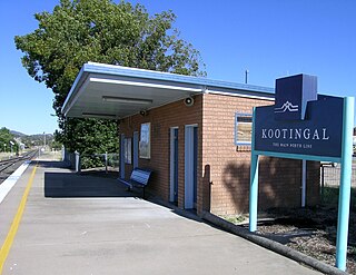
Kootingal railway station is located on the Main Northern line in New South Wales, Australia. It serves the town of Kootingal, opening on 9 January 1882 as Moonbi when the line was extended from West Tamworth. It was the terminus of the line until it was extended to Uralla on 2 August 1882. It was renamed Kootingal on 20 April 1914. Opposite the station lies a passing loop.
Moonby House is a heritage-listed colonial pastoral station and now retirement village located on the New England Highway in Kootingal in the Tamworth Regional Council local government area of New South Wales, Australia. The house was built from 1895 to 1896. It is also known as Moonbi Retirement Homes. The property is owned by the Freemasons Institution of NSW and was added to the New South Wales State Heritage Register on 2 April 1999.
