Overijssel is a province of the Netherlands located in the eastern part of the country. The province's name translates to "across the IJssel", from the perspective of the Episcopal principality of Utrecht by which it was held until 1528. The capital city of Overijssel is Zwolle and the largest city is Enschede. The province had a population of 1,162,215 as of November 2019. The land mostly consists of grasslands and some forests ; it also borders a small part of the IJsselmeer to the west.
North Holland is a province of the Netherlands in the northwestern part of the country. It is located on the North Sea, north of South Holland and Utrecht, and west of Friesland and Flevoland. In November 2019, it had a population of 2,877,909 and a total area of 4,092 km2 (1,580 sq mi), of which 1,430 km2 (550 sq mi) is water.
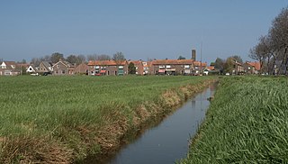
Steenwijkerland is a municipality in the province of Overijssel, in the eastern Netherlands. Prior to a name change in 2003, it was known as Steenwijk.
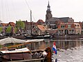
Vollenhove is a city in the Dutch province of Overijssel. It is located in the municipality of Steenwijkerland, southwest of Steenwijk. Until the Noordoostpolder was drained, it was located on the coast of the Zuiderzee.

Blokzijl is a small city located southwest of Steenwijk in the province of Overijssel, the Netherlands. The city is a major tourist destination near the De Weerribben-Wieden National Park and attracts many water sports enthusiasts.
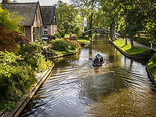
Giethoorn is a village in the province of Overijssel, Netherlands, with a population of 2,795 in 2020. It is located in the municipality of Steenwijkerland, about 5 km (3.1 mi) southwest of Steenwijk. As a popular Dutch tourist destination both within Netherlands and abroad, Giethoorn is often referred to as "Dutch Venice" or the "Venice of the Netherlands".
Bouches-de-l'Yssel was a department of the First French Empire in the present-day Netherlands. It was formed in 1810, when the Kingdom of Holland was annexed by France. Its territory corresponded with the present-day Dutch province of Overijssel. Its capital was Zwolle.

Salland is a historical dominion in the west and north of the present Dutch province of Overijssel. Nowadays Salland is usually used to indicate a region corresponding to the part of the former dominion more or less to the west of Twente.
Brederwiede is a former municipality in the Dutch province of Overijssel. It was created in a merger of Blokzijl, Giethoorn, Vollenhove, and Wanneperveen in 1973, and existed until it became a part of Steenwijk in 2001.

Steenwijkerwold is a village in the Dutch province of Overijssel. It is located in the municipality of Steenwijkerland, about 5 km northwest of Steenwijk. Steenwijkerwold was a separate municipality until 1973, when it became a part of Steenwijk.

Wanneperveen is a village in the Dutch province of Overijssel. It is located in the municipality of Steenwijkerland, about 4 km west of Meppel.

Zwolle is the main railway station of Zwolle in Overijssel, Netherlands. The station opened on 6 June 1864 and is on the Utrecht–Kampen railway, also known as the Centraalspoorweg, the Zwolle–Almelo railway, the Arnhem–Leeuwarden railway, the Zwolle–Stadskanaal railway and the Lelystad–Zwolle railway, also known as the Hanzelijn.
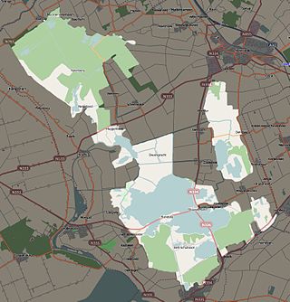
Weerribben-Wieden National Park is a Dutch national park in the Steenwijkerland and Zwartewaterland municipalities in the Overijssel province. Comprising the largest bog of Northwestern Europe, the park consists of two areas, De Weerribben and De Wieden; it has an area of roughly 100 square kilometres (39 sq mi). The park was founded in 1992, although De Wieden was added later, in 2009.
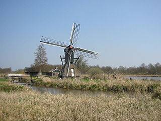
De Wicher is a drainage mill near the village of Kalenberg, Overijssel, Netherlands. It is a hollow post windmill of the type called spinnenkop by the Dutch. The mill is in working order and used to drain the reed beds during winter to improve accessibility for reed cutters.
A Tjasker is a type of small drainage windmill used in the Netherlands and north Germany. There are seven tjaskers remaining in Overijssel, all located in the marshy region in the northwest corner of the province.
Zuidveen is a Dutch village just south of Steenwijk in the municipality of Steenwijkerland. It forms a single urban area with Steenwijk.

The siege of Steenwijk was a siege that took place between 30 May and 5 July 1592 as part of the Eighty Years' War and the Anglo–Spanish War by a Dutch and English force under Maurice of Orange. By taking Steenwijk the Republic's army would take out one of the two main transport routes overland to the Drenthe capital of Groningen, the other lay at Coevorden. After a failed bombardment, an assault was made in conjunction with the detonation of mines under important bastions, and with two out of three successfully assaulted, the Spanish troops surrendered on 5 July 1592 and handed over the city to the Dutch and English army. This siege was one of the first in history to make use of pioneers as a separate military unit although they were still at the time regarded as soldiers.

De Zwaluw is a smock mill in Hasselt, Overijssel, Netherlands which is run by volunteers every Saturday.
Ossenzijl is a village in the municipality Steenwijkerland of the Dutch province of Overijssel. It started as a sluice owned by the Osse family. It is an entry point to the Weerribben-Wieden National Park.

Sint Jansklooster is a village in the municipality Steenwijkerland of the Dutch province of Overijssel. It started as a monastery. The village is located near the Weerribben-Wieden National Park, and organises an annual bloemencorso.