Peshawar is the sixth most populous city of Pakistan, with a population of over 1.97 million in 2017 census. It is situated in the north-west of the country, lying in the Valley of Peshawar. It is the capital of the province of Khyber Pakhtunkhwa, where it is the largest city. Peshawar is primarily populated by Pashtuns, who comprise the second-largest ethnic group in the country. Situated in the Valley of Peshawar, a broad area situated east of the historic Khyber Pass, Peshawar's recorded history dates back to at least 539 BCE, making it one of the oldest cities in South Asia. Peshawar also remained capital of Gandhara civilization and is among the oldest continuously inhabited cities of the country.

A milestone is a numbered marker placed on a route such as a road, railway line, canal or boundary. They can indicate the distance to towns, cities, and other places or landmarks; or they can give their position on the route relative to some datum location. On roads they are typically located at the side or in a median or central reservation. They are alternatively known as mile markers, mileposts or mile posts. A "kilometric point" is a term used in metricated areas, where distances are commonly measured in kilometres instead of miles. "Distance marker" is a generic unit-agnostic term.
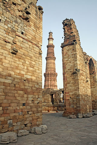
The Qutb Minar complex are monuments and buildings from the Delhi Sultanate at Mehrauli in Delhi, India. Construction of the Qutub Minar "victory tower" in the complex, named after the religious figure Sufi Saint Khwaja Qutbuddin Bakhtiar Kaki, was begun by Qutb-ud-din Aibak, who later became the first Sultan of Delhi of the Mamluk dynasty. It was continued by his successor Iltutmish, and finally completed much later by Firoz Shah Tughlaq, a Sultan of Delhi from the Tughlaq dynasty (1320–1412) in 1368 AD. The Qubbat-ul-Islam Mosque, later corrupted into Quwwat-ul Islam, stands next to the Qutb Minar.

The Grand Trunk Road is one of Asia's oldest and longest major roads. For at least 2,500 years it has linked Central Asia to the Indian subcontinent. It runs roughly 2,400 km (1,491 mi) from Teknaf, Bangladesh on the border with Myanmar west to Kabul, Afghanistan, passing through Chittagong and Dhaka in Bangladesh, Kolkata, Lucknow, Delhi, and Amritsar in India, and Lahore, Gujrat, Rawalpindi, and Peshawar in Pakistan.
The Qutb Minar, also spelled Qutub Minar and Qutab Minar, is a minaret and "victory tower" that forms part of the Qutb complex, which lies at the site of Delhi’s oldest fortified city, Lal Kot, founded by the Tomar Rajputs. It is a UNESCO World Heritage Site in the Mehrauli area of South Delhi, India. It is one of the most visited tourist spots in the city, mostly built between 1199 and 1220.

The Agra Fort is a historical fort in the city of Agra, and also known as Agra's Red Fort. Mughal emperor Humayun was crowned at this fort. It was later renovated by the Mughal emperor Akbar from 1565 and the present-day structure was completed in 1573. It served as the main residence of the rulers of the Mughal dynasty until 1638, when the capital was shifted from Agra to Delhi. It was also known as the "Lal-Qila" or "Qila-i-Akbari". Before capture by the British, the last Indian rulers to have occupied it were the Marathas. In 1983, the Agra fort was inscribed as a UNESCO World Heritage Site because of its importance during the Mughal Dynasty. It is about 2.5 kilometers (1.6 mi) northwest of its more famous sister monument, the Taj Mahal. The fort can be more accurately described as a walled city. It was later renovated by Shah Jahan.

Mughal architecture is the type of Indo-Islamic architecture developed by the Mughals in the 16th, 17th and 18th centuries throughout the ever-changing extent of their empire in the Indian subcontinent. It developed from the architectural styles of earlier Muslim dynasties in India and from Iranian and Central Asian architectural traditions, particularly Timurid architecture. It also further incorporated and syncretized influences from wider Indian architecture, especially during the reign of Akbar. Mughal buildings have a uniform pattern of structure and character, including large bulbous domes, slender minarets at the corners, massive halls, large vaulted gateways, and delicate ornamentation; examples of the style can be found in modern-day Afghanistan, Bangladesh, India and Pakistan.

Indo-Islamic architecture is the architecture of the Indian subcontinent produced by and for Islamic patrons and purposes. Despite an initial Arab presence in Sindh, the development of Indo-Islamic architecture began in earnest with the establishment of Delhi as the capital of the Ghurid dynasty in 1193. Succeeding the Ghurids was the Delhi Sultanate, a series of Central Asian dynasties that consolidated much of North India, and later the Mughal Empire by the 15th century. Both of these dynasties introduced Islamic architecture and art styles from West Asia into the Indian subcontinent.

Taraori, or Tarori or Tarawari, as it is sometimes called in the local dialect, is a town in Nilokheri Tehsil of Karnal district in the Indian state of Haryana. It is situated off NH-44, 14 km north of Karnal. The name Taraori is derived from the word Tarai.

Delhi has been an important political centre of India as the capital of several empires. The recorded history of Delhi begins with the 8th century Tomar Rajputs kingdom. It is considered to be a city built, destroyed and rebuilt several times, as outsiders who successfully invaded the Indian subcontinent would ransack the existing capital city in Delhi, and those who came to conquer and stay would be so impressed by the city's strategic location as to make it their capital and rebuild it in their own way.

Sikandar Shah Suri was the sixth ruler of the Sur dynasty, a late medieval Pashtun dynasty of northern India. He became the sultan of Delhi after overthrowing Ibrahim Shah Suri.

Gharaunda is a town and a municipal committee in Karnal district in the state of Haryana, India. It is situated at a distance of sixty-five miles to the northwest of New Delhi. It is eleven miles from Karnal, the district headquarters. The Amritsar-Delhi main broad-gauge railway line passes through the town. Indo-Israel Centre For Excellence in Vegetables and one of the leading footwear industries of India 'Liberty Shoes' has its manufacturing unit in Gharaunda. This has given fame to the place. Gharaunda serves as a big Grain market for the state.
Pakistani architecture is intertwined with the architecture of the broader Indian subcontinent. The major architectural styles popular in the past were Temple, Indo-Islamic, Mughal and Indo-Saracenic architecture, all of which have many regional varieties. With the beginning of the Indus civilization around the middle of the 3rd millennium BC, for the first time in the area which encompasses today's Pakistan an advanced urban culture developed with large structural facilities, some of which survive to this day. This was followed by the Gandhara style of Buddhist architecture that borrowed elements from Ancient Greece. These remnants are visible in the Gandhara capital of Taxila.
The History of Khyber Pakhtunkhwa refers to the history of the modern-day Pakistani province of Khyber Pakhtunkhwa.

The Naulakha Pavilion is a white marble personal chamber with a curvilinear roof, located beside the Sheesh Mahal courtyard, in the northern section of the Lahore Fort in Lahore, Pakistan. The monument is one of the 21 monuments situated within the Lahore Fort, with its western façade providing a panoramic view of the ancient city of Lahore.

The Afghan-Maratha War was fought between the Afghan Empire under Ahmad Shah Durrani and the Maratha Empire and the Sikh Confederacy between 1758 and 1761. It took place in north-west India, primarily the region around Delhi and Punjab.

Persian Inscriptions on Indian Monuments is a book written in Persian by Dr Ali Asghar Hekmat E Shirazi and published in 1956 and 1958 and 2013. New edition contains the Persian texts of more than 200 epigraphical inscriptions found on historical monuments in India, many of which are currently listed as national heritage sites or registered as UNESCO world heritage, published in Persian; an English edition is also being printed.
Tourism in Haryana relates to tourism in the state of Haryana, India. There are 21 tourism hubs created by Haryana Tourism Corporation (HTC), which are located in Ambala, Bhiwani Faridabad, Fatehabad, Gurgaon, Hisar, Jhajjar, Jind, Kaithal, Karnal, Kurukshetra, Panchkula, Sirsa, Sonipat, Panipat, Rewari, Rohtak, Yamunanagar, Palwal and Mahendergarh.

The Subah of Lahore was a province of the Mughal Empire encompassing the central Punjab region, now divided between Pakistan and India. It was created as one of the original 12 Subahs of the Mughal Empire under the administrative reforms carried by emperor Akbar in 1580. The province ceased to exist after the death of its last viceroy, Adina Beg in 1758, with large parts being incorporated into Durrani Empire.
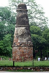
The Victoria Memorial Hall is situated in Karnal city of Haryana, India. It stands near the city's Committee Chowk, Karnal, OLD National Highway 1 of India. The monument is located in the main market of Karnal City. This monument is listed as "State Protected Monuments" by the Department of Archaeology and Museums, Haryana..