Krainz Woods

Last updated

Krainz Woods (colloquially known as Krainz and Krainz Park) is a neighborhood in Detroit, Michigan.

Contents

The neighborhood was named after Captain John Krainz Jr., a World War II hero from Detroit. [1] The neighborhood was once home to Malcolm X, who lived on Keystone Street in the 1950s, [2] and Spencer Haywood in the 1960s. The Sojourner Truth housing project is located there. Many Motown singing groups, such as The Dramatics and The Floaters, were from the Sojourner Truth housing projects. In 2009, Mayor of Detroit Dave Bing led a ribbon-cutting dedication of Krainz Park. [3]

History

Originally, Krainz Woods was a deeply wooded area located west of the Village of Norris. It later became a part of Hamtramck Township, and the City of Detroit annexed the area in 1916. Between 1923 and 1940, about 1,000 houses were constructed in Krainz Woods. [4] In 1966 the Krainz Woods Neighborhood Organization was mostly White. During that year, the organization posted an advertisement in an African-American newspaper that asked Conant Gardens residents to go to a meeting at an area church to protest a proposed scattered-site housing and open occupancy. The whites in Krainz Woods wanted to recruit middle class blacks in Conant Gardens to oppose public housing. [5]

Ten prisoners escaped from the Ryan Correctional Facility on August 21, 1994. Nine prisoners were recaptured and, according to authorities, one died of a drug overdose. [6] On Monday August 29, 1994 a group of about 500 area residents held a meeting in the W.L. Bonner Cultural Center about the prison, and the residents decided that they needed to have the prison closed. The residents said that, prior to the prison's construction, the state had said that "harden" and "violent" criminals would not be held in that facility. [7] On November 5, 1994, about sixteen members of the Krainz Woods Neighborhood Organization, including at least eight elderly people, demonstrated in front of the Ryan Correctional Facility, saying that the state did not implement promised measures, improving neighborhood lighting, hiring employees from the neighborhood, and implementing a grant to pay for security doors on the houses of the residents. [6]

Cityscape

The Krainz Woods Neighborhood Organization serves a 17-city block area, [7] east of Conant Gardens, [4] and adjacent to the Detroit Reentry Center (formerly the Ryan Correctional Facility), [6] and the Mound Correctional Facility. [8] The community is bounded by Ryan Road, Mound Road, Nevada, and 7 Mile Road East. [7] Due to its proximity to Conant Gardens, Krainz Woods is often mistaken for, and erroneously considered as part of, that neighboring community.

The Krainz Woods business community consists of The Bay at Cranbrook Health and Rehabilitation Center, three party stores (F&S Market, Moore Market and Piper Liquors), and two restaurants (Nevada Coney Island, and 7's Deli).

Education

Residents are zoned to Detroit Public Schools. Mason Elementary-Middle School serves K-8. [9] [10] Pershing High School serves 9–12. [11]

The National Heritage Academies Legacy Charter Academy, located in the former Atkinson Elementary School, [12] is in Krainz Woods. [13]

Previously Atkinson Elementary School in Krainz Woods served the community as the zoned elementary school. [14] At one time Van Zile Elementary School served the community. [15] Previously Farwell Middle School served the community. [16] [17]

Related Research Articles

<span class="mw-page-title-main">Hamtramck, Michigan</span> City in Michigan, United States

Hamtramck is a city in Wayne County in the U.S. state of Michigan. As of the 2020 census, the city population was 28,433. Hamtramck is surrounded by the city of Detroit except for a small portion that borders the fellow enclave city of Highland Park. Hamtramck is by far the most densely populated municipality in the state of Michigan, and the only Muslim-majority town in the United States.

Poletown East is an industrial district of Detroit, Michigan, bordering the enclave city of Hamtramck. The area was named after the Polish immigrants who originally lived in the area. A portion of residential area known as Poletown became the General Motors Detroit/Hamtramck Assembly plant in 1981 with those residents relocated by General Motors and the cities of Detroit and Hamtramck which claimed eminent domain in order to make way for a new automobile plant.

<span class="mw-page-title-main">Indian Village, Detroit</span> United States historic place

Indian Village is a neighborhood located in Detroit, Michigan, bounded to the north and south by Mack Avenue and East Jefferson Avenue, respectively, along the streets of Burns, Iroquois, and Seminole. The district was listed on the National Register of Historic Places in 1972.

Warrendale is a neighborhood located in Detroit, Michigan, bordered by Greenfield East Road, Joy Road, and the Detroit city limits. Warrendale neighbors Dearborn on two sides and Dearborn Heights on another side.

<span class="mw-page-title-main">Brightmoor, Detroit</span> Neighborhood of Detroit, Michigan

Brightmoor is a neighborhood located in Detroit, Michigan, near the northwest border of the city. Brightmoor is defined by the Brightmoor Alliance as being bordered by Puritan Road to the north, the CSX railway to the south, Evergreen Road to the east, and Outer Drive West, Dacosta Street, and Telegraph Road to the west. However, the demographics given here for the neighborhood are the city's statistical Master Plan Neighborhood area, which consists of eight census tracts that includes some areas outside of the Alliance's boundaries, but does not include some areas within its boundaries.

Michigan's 13th congressional district is a United States congressional district in Wayne County, Michigan. It is currently represented by Democrat Shri Thanedar.

Conant Gardens is a historically Black neighborhood in northeast Detroit, Michigan. The neighborhood was once the most exclusive Black neighborhood in that city, and residents of Conant Gardens comprised the most highly educated Black enclave in Detroit.

Michigan's 14th congressional district was a congressional district that stretches from eastern Detroit westward to Farmington Hills, then north to the suburb of Pontiac. From 1993 to 2013, it was based entirely in Wayne County.

<span class="mw-page-title-main">Boston–Edison Historic District</span> Historic district in Michigan, United States

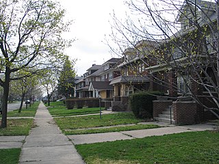
The Boston–Edison Historic District is a neighborhood located in Detroit, Michigan. It consists of over 900 homes built on four east/west streets: West Boston Boulevard, Chicago Boulevard, Longfellow Avenue, and Edison Avenue, stretching from Woodward Avenue on the east to Linwood Avenue on the west. It is one of the largest residential historic districts in the nation. It is surrounded by Sacred Heart Major Seminary to the west, the Arden Park-East Boston Historic District and the Cathedral of the Most Blessed Sacrament to the east, and the Atkinson Avenue Historic District to the south. The district was designated a Michigan State Historic Site in 1973 and listed on the National Register of Historic Places in 1975.

<span class="mw-page-title-main">Atkinson Avenue Historic District</span>

Atkinson Avenue is an east/west street located in the geographic heart of the city of Detroit, Michigan. The historic district had 225 houses in 2010.

<span class="mw-page-title-main">Palmer Woods</span> United States historic place

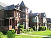
The Palmer Woods Historic District is a neighborhood located in Detroit, Michigan, bounded by Seven Mile Road, Woodward Avenue, and Strathcona Drive. There are approximately 295 homes in the 188-acre (0.76 km2) district, which is between the City of Highland Park in Wayne County and the City of Ferndale in Oakland County. It was listed on the National Register of Historic Places in 1983. The Detroit Golf Club is nearby.

<span class="mw-page-title-main">Palmer Park Apartment Building Historic District</span> Historic district in Michigan, United States

The Palmer Park Apartment Building Historic District is a neighborhood located in Detroit, Michigan, bounded by Pontchartrain Boulevard on the west, McNichols Road on the south, and Covington Drive on the northeast. A boundary increase pushed the eastern boundary to Woodward Avenue. The district showcases some of the most ornate and most varied examples of apartment building design in Michigan, and was listed on the National Register of Historic Places in 1983.

<span class="mw-page-title-main">Rosedale Park, Detroit</span> United States historic place

Rosedale Park is a historic district located in Detroit, Michigan. It is roughly bounded by Lyndon, Outer Drive, Grand River Avenue, Southfield Freeway, Glastonbury Avenue, Lyndon Street and Westwood Drive. It was listed on the National Register of Historic Places in 2006. The Rosedale Park district has the largest number of individual properties of any district nominated to the National Register of Historic Places in Michigan, with 1533.

Sherwood Forest is a neighborhood in Detroit, Michigan. The neighborhood is bounded by Seven Mile Road, Livernois, Pembroke, and Parkside. The community, with about 435 houses, consists of two subdivisions: Sherwood Forest and Sherwood Forest Manor.

<span class="mw-page-title-main">Greenfield Union School</span> United States historic place

The Greenfield Union School is a school located at 420 West 7 Mile Road in Detroit, Michigan. A part of Detroit Public Schools (DPS), the school building was listed on the National Register of Historic Places in 2011.

<span class="mw-page-title-main">Boynton–Oakwood Heights</span> Neighborhoods of Detroit in Wayne, Michigan, United States

Boynton and Oakwood Heights are the two southernmost neighborhoods of the city of Detroit in the U.S. state of Michigan. The two neighborhoods occupy the only portions of Detroit located south of the River Rouge.

Osborn is a community in northeast Detroit, Michigan. The Skillman Foundation selected Osborn to be one of the neighborhoods covered by the Good Neighborhoods Initiative.

Detroit Reentry Center (RRF), previously the Ryan Correctional Facility, is a prison of the Michigan Department of Corrections located in eastern Detroit, Michigan. It is adjacent to the Detroit Detention Center.

Mound Correctional Facility was a Michigan Department of Corrections (MDOC) prison located in eastern Detroit, Michigan. It was adjacent to the Detroit Reentry Center. The facility which housed Mound was reopened in August 2013 as the Detroit Detention Center.

References

Notes

  1. "Detroit urbanism, Detroit preservation, Detroit architecture, Detroit urban planning, Detroit buildings, Detroit historic preservation". Cityscapedetroit.org. 2005-05-19. Archived from the original on 2013-12-15. Retrieved 2012-11-29.
  2. Carson, Clayborne (February 2012). Malcolm X: The FBI File. ISBN   9781626366381.
  3. "Photograph of Opening Ceremony". Img.timeinc.net. Retrieved 2012-11-29.
  4. 1 2 Scott, Gene, p. 55. "Once a deeply- wooded area west of the village of Norris, Krainz Woods is part of an area of Hamtramck township annexed in 1916. Approximately 1,000 homes were built there between 1923 and 1940. It is just east of Conant Gardens."
  5. Shaw, p. 44.
  6. 1 2 3 Scott, Nathaniel. "Community continues prison demonstration." Michigan Citizen , in the Michigan Quarterly Review . November 26, 1994. Retrieved on December 28, 2012. Available on HighBeam.
  7. 1 2 3 Scott, Nathaniel. "PRISON BREAK: Two Views. OUTSIDE: Community wants Ryan prison closed." Michigan Citizen , in the Michigan Quarterly Review . September 4, 1994. Retrieved on December 28, 2012. Available on HighBeam.
  8. "Mound Correctional Facility." Michigan Department of Corrections. Retrieved on December 28, 2012.
  9. "Elementary Boundaries – 2012/13 School Year ." (Archive) Detroit Public Schools. Retrieved on November 1, 2012.
  10. "Middle School Boundaries – 2012/13 School Year Archived 2013-01-30 at the Wayback Machine ." (Archive) Detroit Public Schools. Retrieved on November 1, 2012.
  11. "High School Boundaries – 2012/13 School Year ." (Archive) Detroit Public Schools. Retrieved on November 1, 2012.
  12. "Atkinson Elementary School." Detroit Public Schools. June 9, 2003. Retrieved on December 28, 2012. "4900 Hilldale, Detroit, MI. 48234 "
  13. "Legacy Charter Academy." National Heritage Academies. Retrieved on December 28, 2012. "4900 E. Hildale Street Detroit, MI 48234"
  14. "Elementary School Attendance Areas." Detroit Public Schools. July 10, 2003. Retrieved on November 2, 2012.
  15. "Elementary School Boundary Map." Detroit Public Schools . Retrieved October 20, 2009.
  16. "Middle School Attendance Areas." Detroit Public Schools . July 10, 2003. Retrieved on November 2, 2012.
  17. "Middle School Boundary Map." Detroit Public Schools . Retrieved October 20, 2009.

Further reading

Coordinates: 42°25′47″N83°03′15″W / 42.4297°N 83.0542°W / 42.4297; -83.0542