
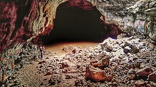
Kuna Caves are lava tubes found south of Kuna, Idaho. There is currently one publicly known entrance to the cave, an opening in the ground with a caged ladder leading down into the cave.
Kuna Caves are lava tubes found south of Kuna, Idaho. There is currently one publicly known entrance to the cave, an opening in the ground with a caged ladder leading down into the cave.
The caves are about 50 feet (15 m) deep and run about a quarter mile north and around 1,000 feet (300 m) south from the entrance. The southern portion of the cave requires you to crawl through a trench dug out of the clay floor of the cave leading to a small space approximately 4 feet (1.2 m) long by 3 feet (0.91 m) wide by 3 feet (0.91 m) high in which you can turn around to return to the main cavern. [1]
Though according to locals, at one time the system had been much larger and was composed of multiple caves, even stretching to the Snake River, before the United States Army Corps of Engineers blocked it off by detonating dynamite collapsing a portion of the cave. [2] A logbook was placed deep in the North end of the cave for people to sign in 2018. Although the entrance has a ladder to get down into the cavern, it is not maintained. The short road leading to the cave is unmaintained, often very muddy, and the cave itself is littered with trash and graffiti. The interior temperature of the cave hovers around 56 °F (13 °C) year round. [3]
The official Bureau of Land Management stance on the cave is that it should not be visited by the general public.
The Natural Bridge Caverns are the largest commercial caverns in the US state of Texas. The name is derived from the 60-foot (18 m) natural limestone slab bridge that spans the amphitheater setting of the cavern's entrance. The span was left suspended when a sinkhole collapsed below it.

Russell Cave National Monument is a U.S. national monument in northeastern Alabama, United States, close to the city of Bridgeport. The monument was established on May 11, 1961, when 310 acres (1.3 km2) of land were donated by the National Geographic Society to the American people. It is now administered and maintained by the National Park Service. The national monument was listed on the National Register of Historic Places on October 15, 1966.

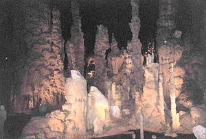
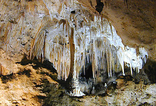
Luray Caverns, previously Luray Cave, is a cave just west of Luray, Virginia, United States, which has drawn many visitors since its discovery in 1878. The cavern system is adorned with speleothems such as columns, mud flows, stalactites, stalagmites, flowstone, and mirrored pools. The caverns host the Great Stalacpipe Organ, a lithophone made from solenoid-fired strikers that tap stalactites of varied sizes to produce tones similar to those of xylophones, tuning forks, or bells.

At 150.4 miles (242.0 km), Lechuguilla Cave is the eighth-longest explored cave in the world and the second deepest in the continental United States. It is most famous for its unusual geology, rare formations, and pristine condition.
Cathedral Caverns State Park is a public recreation area and natural history preserve located in Kennamer Cove, Alabama, approximately 5 miles (8.0 km) northeast of Grant and 7 miles (11 km) southeast of Woodville in Marshall County. The park, first known as Bats Cave, was developed as a tourist attraction in the 1950s. Cathedral Caverns was declared a National Natural Landmark in 1972 and opened as a state park in 2000.

Colossal Cavern is a cave in Kentucky, United States, the main entrance of which is at the foot of a steep hill beyond Eaton Valley, and 1.5 miles from Mammoth Cave.
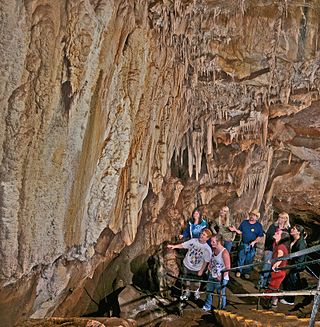
Mystic Caverns and Crystal Dome are show caves located between the cities of Jasper and Harrison, in the state of Arkansas, U.S., on the Arkansas Highway 7 Scenic Byway near the defunct amusement park Dogpatch USA. Sometimes called "the twin caves" because they are within 400 feet (120 m) of each other, the two caves maintain a year-round temperature of 58 °F, contain more formations per foot than any other caves in Arkansas, and are open for public tours year-round except during the January flooding season.

Illinois Caverns is a state natural area in the New Design Precinct of Monroe County, Illinois. It features Illinois Caverns which is alternatively known as Mammoth Cave of Illinois. Illinois Caverns is the second-largest cave in Illinois and has more than 9.6 km of passages. The cave has a constant temperature of 58 °F (14 °C), and portions flood during wet weather. Passages can be 20 feet (6.1 m) high and just as wide. It is located off Illinois Route 3, south of Waterloo, near the unincorporated community of Burksville.

Sea Lion Caves is a connected system of sea caves and caverns open to the Pacific Ocean in the U.S. state of Oregon. They are located 11 miles (18 km) north of Florence on U.S. Highway 101, about midpoint on the 400 miles (640 km) Oregon Coast. In this area Highway 101 follows a steep and undeveloped seascape 300 feet (91 m) above sea level. Human access to the caves is through a gift shop building.

Devils Hole is a geologic formation located in a detached unit of Death Valley National Park and surrounded by the Ash Meadows National Wildlife Refuge, in Nye County, Nevada, in the Southwestern United States.

Carlsbad Caverns National Park is an American national park in the Guadalupe Mountains of southeastern New Mexico. The primary attraction of the park is the show cave Carlsbad Cavern. Visitors to the cave can hike in on their own via the natural entrance or take an elevator from the visitor center.
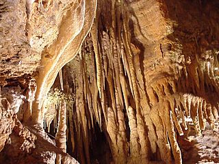
Mercer Caverns is a show cave located one mile north of Murphys in Calaveras County California. It is named after the gold prospector Walter J. Mercer who discovered the caves around 1885 and filed a claim. The caverns have a large number of speleothems, stalactites, and stalagmites. It is formed in a marble unit known as the Calaveras Formation. It also contains a large display of aragonite frostwork. The standard tour of the cave descends 160 feet, 208 steps down and 232 up in a traverse between the natural and an artificial entrance. The cave was mapped in 1986 to a length of 3389 feet and a total depth of 192 feet. The map can be viewed on the cave's web site.
Crystal Grottoes is the only show cave in the U.S. state of Maryland. It is located on Maryland Route 34 between Boonsboro and Antietam National Battlefield.
The Boise meridian is one of the 35 principal meridians of the Public Land Survey System of the United States. Adopted in 1867, its longitude is 116° 23′ 35″ west from Greenwich and its principal baseline is latitude 43° 22′ 21″ north. The meridian and baseline intersect approximately 19 miles (31 km) from Boise, between the Snake River and the Boise River. The Boise meridian governs land surveys in the state of Idaho.
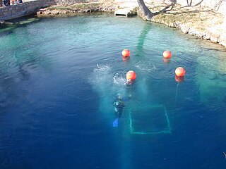
The Blue Hole of Santa Rosa, or simply the Blue Hole, is a circular, bell-shaped pool or small lake located along Route 66 east of Santa Rosa, New Mexico that is a tourist attraction and swimming venue, and one of the most popular dive destinations in the US for scuba diving and training. The Blue Hole is an artesian well and cenote that was once used as a fish hatchery.
Pluto's Cave is a partially collapsed lava tube on the northern outskirts of Mount Shasta in the Klamath National Forest. Its main entrance is located close to the 99-97 Cutoff c. 12 miles (19 km) North-east of Weed and c. 14 miles (23 km) East-southeast of Grenada. The tube is roughly 190,000 years old, which is quite old for a lava tube, as they normally collapse quickly, having ceilings only a few metres thick. However, Pluto's Cave is located in a semi-arid climate, where erosion is restricted, which contributes to its survival.

The Falemauga Caves are large natural caverns in a series of lava-tunnels situated in the Tuamasaga district along the central ridge of Upolu island in Samoa. The caves have been studied by archaeologists in Samoa with evidence of human occupation in pre-history. They were also used as a place of refuge by the people of Tuamasaga.
McArthur Lake is a reservoir in Boundary County, Idaho, USA. It gives its name to the McArthur Lake Wildlife Corridor, which provides a bridge for wildlife to migrate between two mountainous areas. The reservoir and surrounding wetlands are rich in bird life, and are protected by the McArthur Lake Wildlife Management Area. There has been discussion about removing the dam that impounds the reservoir, which would improve the wetlands so they would support larger numbers of game birds, and would also improve the quality of water downstream.
43°24′43.7″N116°26′59.0″W / 43.412139°N 116.449722°W
| | This Ada County, Idaho state location article is a stub. You can help Wikipedia by expanding it. |