L'Arbre Croche

Last updated
L'Arbre Croche
Waganagisi
Region
Etymology: crooked tree
USA Michigan location map.svg
Red pog.svg
L'Arbre Croche
Coordinates: 45°37′35″N85°4′12″W / 45.62639°N 85.07000°W / 45.62639; -85.07000 (site of a historical marker in the center of what was the L'Arbre Croche region)
CountryUnited States
StateMichigan
County Emmet County

L'Arbre Croche, known by the Odawa people as Waganagisi, was a large Odawa settlement in Northern Michigan. [1] The French called it L'Arbre Croche for the large crooked tree that marked the center of the settlement and was visible for many miles. It covered the region from Harbor Springs to Cross Village in present-day Emmet County, Michigan. [2]

Contents

The Odawa moved with Jesuit missionaries to the L'Arbre Croche area in 1741. During the 18th and 19th centuries, the L'Arbre Croche community was closely affiliated with the French, British, and Americans stationed at the trading post and military garrison at Fort Michilimackinac and Fort Mackinac. The Odawa supplied furs, canoes, and food for the fur trade. They were particularly interdependent with the French, who established missions and churches in the community.

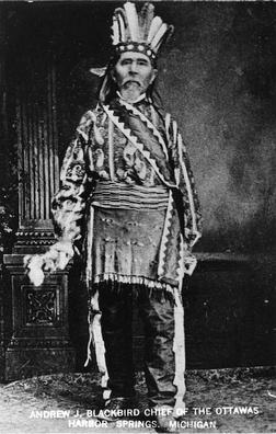
During the 1750s and 1760s, a smallpox outbreak devastated several indigenous communities in the region. An oral account from Odawa tribal leader and historian Andrew Blackbird claimed that the outbreak had "entirely depopulated and laid waste" to L'Arbre Croche. After the 1763 Treaty of Paris, the French vacated the region, and the British took control over Fort Michilimackinac.

Nissowaquet and the community's warriors sided with the British during the American Revolutionary War (1775–1783) and participated in several expeditions. After the area became part of the Michigan Territory (1805–1837), Native Americans lost much of their land. In 1836, the Odawa gave up land across most of the Eastern Upper Peninsula and Northern Lower Peninsula when they signed the Treaty of Washington. Chief Joseph Nowimashkote initiated a plan for the Odawa to buy back their land at Cross Village, also called La Croix in the 19th century. The village of Harbor Springs—established with a church, manse, a school, and the country's first temperance society—became the center of the L'Arbre Croche community in the early 19th century.

L'Arbre Croche is also known as the present Catholic community encompassing four churches, one of which is the St. Ignatius Church of Middle Village. [3]

Etymology

L'Arbre Croche means the crooked tree in French. The hooked top of the large pine tree was a prominent landmark for travelers on Lake Michigan. The tree, no longer standing, was located near Middle Village, 20 miles (32 km) north of Harbor Springs [3] [4] The Odawa name for the community was Waganagisi, meaning bent tree. [3] [4]

Background

Michigan in 1718, Guillaume de L'Isle map, approximate state area highlighted. L'Arbre Croche is located southwest of Michilimackinac and along the shore of Lake Michigan to Little Traverse Bay Michigan 1718.jpg
Michigan in 1718, Guillaume de L'Isle map, approximate state area highlighted. L'Arbre Croche is located southwest of Michilimackinac and along the shore of Lake Michigan to Little Traverse Bay

The French operated a fur trading post at Michilimackinac, in what is now the state of Michigan. The Odawa in the area traded fur pelts with the French. Jesuit missionary Jacques Marquette (1637–1675) established St. Ignace Mission at Michilimackinac in the late 17th century. [5] Pierre du Jaunay, a Jesuit priest from France, served as a missionary at Michilimackinac beginning in 1735. From the Sainte-Anne log church, he served the French and later British residents, neighboring Native Americans, and visiting traders and explorers for almost 30 years. [6] Nissowaquet was among the Odawa who lived at the village alongside Fort Michilimackinac. [7]

In 1740, the Odawa determined that they needed to relocate to more arable land. Fort Michilimackinac Commandant Pierre Joseph Céloron de Blainville (Céloron) led the Odawa chiefs to Quebec to hold a council with the Marquis de Beauharnois (Beauharnois), who offered several locations for the Odawa to establish themselves. [5] With Du Jaunay's encouragement, the Odawa chose the nearby area known as L'Arbre Croche. [6]

History

New France (1534–1763)

Little Traverse Bay at sunset, looking north from Petoskey Little Traverse Bay at sunset.jpg
Little Traverse Bay at sunset, looking north from Petoskey

The Odawa, including Nissowaquet and around 180 warriors, moved to L'Arbre with the Jesuits in the summer of 1741 [5] [7] and they established a mission called Apatawaaing. [3] L'Arbre Croche, also known by the Odawa name Waganagisi, was the largest settlement in the Great Lakes at the time. [1] [8] It encompassed much of present-day Emmet County, Michigan, [8] with a number of villages along the shoreline from Fort Michilimackinac down to Little Traverse Bay. [9] [10] [lower-alpha 1] Beauharnois sent French men from Michilimackinac to help til the soil. [10] A church was built at Cross Village in 1742 by master carpenter Joseph Ainse. [10] Du Jaunay split his time between the Sainte-Anne church and the Saint-Ignace at L’Arbre Croche mission in Cross Village, where he had a farm. He was assisted by several French priests and some Native American slaves. [6]

The Odawa of L'Arbre Croche fished, hunted, and grew and gathered produce, including corn, squash, onions, cucumbers, turnips, cabbages, melon, and wild strawberries. [12] The Odawa bartered with the French at Mackinac Island, a major fur-trading center where Lake Huron meets Lake Michigan. They traded food, bark, and canoes for good, like clothing and glass and porcelain beads. The canoes and food–including dried fish and meat and produce–supplied the fur traders who worked in the wilderness of the Great Lakes and the Upper Mississippi regions. [13] In the fall, the Odawa moved south to the St. Joseph River and other rivers where they divided into family bands who hunted for furs. In the spring, they made maple sugar and headed back to L'Arbre Croche. [7]

British rule (1763–1787)

Ojibwas of Michilimackinac attacked the now British fort (Treaty of Paris (1763)), in June 1763. They were led by Minweweh, who was staunchly loyal to the French. [14] Surviving traders and soldiers were rescued and taken by Nissowaquet's warriors to L'Arbre Croche, where they were protected for a month. Nissowaquet was rewarded with a personal slave and a supply of trade goods. Some of the goods were used to purchase the captivity of captives from the Ojibwas. Nissowaquet brought refugees from the fort to the British in Montreal. He promised as good a relationship with the British as he had with the French. [7] The British and the American governments did not support the mission and would not pay the salary for a priest after Du Jaunay's departure in 1765. [15] [16]

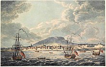
Montreal occupied following the French and Indian War, viewed from the East with Royal Navy vessels in the foreground Vue orientale de Montreal, en Canada.jpg
Montreal occupied following the French and Indian War, viewed from the East with Royal Navy vessels in the foreground

Beginning from the 1750s and lasting until the 1760s, a smallpox outbreak devastated several Indian communities throughout the American Midwest, including L'Arbre Croche. The outbreak was brought on in part by victorious Indian warriors who had fought on the side of the French bringing home prizes of war which had been infected with the disease; the Ojibwe, Odawa and Potawatomi peoples were most affected by the outbreak. An oral account from Odawa tribal leader and historian Andrew Blackbird claimed that the outbreak had "entirely depopulated and laid waste" to L'Arbre Croche. [17] [lower-alpha 2] Blackbird claimed in his oral account that a group of Odawa were sold a tin box in Montreal, and were told the box contained something supernatural but that they were not to open it until they returned to their homeland. The box supposedly contained four or more nested boxes, until the final box which was one inch in size and contained moldy particles which were smallpox. According to the oral account, entire families of L'Arbre Croche died due to the outbreak and the population of the region was greatly reduced. [17] [18]

A photograph of Fort Michilimackinac in Mackinaw City, Michigan (taken on 9 July 2004) Fort Michilimackinac 2.jpg
A photograph of Fort Michilimackinac in Mackinaw City, Michigan (taken on 9 July 2004)

Nissowaquet sided with the British during the American Revolutionary War (1775–1783) and participated in several expeditions with his warriors. [7]

Northwest Territory (1787–1803)

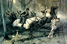
Charge of the Dragoons at Fallen Timbers by R. T. Zogbaum, 1895, Battle of Fallen Timbers Fallen timbers.jpg
Charge of the Dragoons at Fallen Timbers by R. T. Zogbaum, 1895, Battle of Fallen Timbers

The Odawa and Ojibwa from northern Michigan fought with other Native Americans against the United States government at the Battle of Fallen Timbers in 1794. The indigenous people fought to protect their traditional lands from westward expansion. Having lost the battle, Mackinac Island went to the United States as negotiated in the Treaty of Greenville. [19]

In 1799, Father Gabriel Richard, a Catholic missionary from Detroit, visited the Odawa at L'Arbre Croche. Soon after, a smallpox epidemic spread through the Great Lakes region. More than one-half of L'Arbre Croche settlement's residents died. The Odawa believed deaths were retributions, either because Richard's religion was evil or that the Great Spirit was angered by the possibility of the natives accepting Catholicism. [20]

Michigan Territory (1805–1837)

Tenskwatawa, also known as the Shawnee Prophet, by George Catlin, 1830 Ten-squat-a-way.jpg
Tenskwatawa, also known as the Shawnee Prophet, by George Catlin, 1830

In 1807, an Odawa warrior named Le Maigouis, also known as The Trout, traveled from his home in L'Arbre Croche to Tenskwatawa's village in Ohio. Tenskwatawa, also called the Shawnee Prophet, founded a religion that Trout wished to learn more about. Trout returned to Michigan, where he successfully spread the religion to the Odawa and Ojibwa of L'Arbre Croche and the northern peninsula of Michigan. [21] The prophet sought to effectuate "spiritual salvation and cultural renewal” by returning to traditional social ethics, including care for the widowed and respect for elders. He also called for giving up the ways of the white people, such as the use of alcohol, firearms, and European cookware. [19] Another message was to hunt only the animals needed to feed and clothe the tribe, and not to provide food for the White fur traders, which would help restore the number of game in the region. [21] The prophet's brother, Tecumseh helped spread the religion throughout the Great Lakes region. [22]

Homelands of Anishinaabe and Oji-Cree, ca. 1800. The Ojibwe, Potawatomi and Odawa formed a loose confederation called the Council of Three Fires Anishinaabe-Anishinini Distribution Map.svg
Homelands of Anishinaabe and Oji-Cree, ca. 1800. The Ojibwe, Potawatomi and Odawa formed a loose confederation called the Council of Three Fires

By September 1807, the Odawa had stopped buying liquor at Michilimackinac. It had been a lucrative product and traders tried to regenerate demand by giving away gallons of alcohol, without any takers. [22] In 1808, some of the converts moved to Tenskwatawa's village, Prophetstown, in present-day northwest Indiana. The settlement, however, was not able to support the number of arrivals. There was not sufficient farmland and the prophet disallowed trading for food with the Whites. As people starved, they resorted to eating their horses and then their dogs. More than 100 people from L'Arbre Croche died and the surviving disenchanted people returned to their homeland. [23]

L'Arbre Croche was a collection of ten villages, with a population of 1500, in 1819. [24] By 1820, between 1,000 and 1,200 Odawa lived in the Little Traverse Bay area of L'Arbre Croche. They lived in clusters of lodges along the shore of the bay. [25]

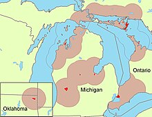
Odawa settlement areas OdaawaaAreas.jpg
Odawa settlement areas

In 1825, the United States government granted funds for a Catholic priest. A log chapel, named after St. Vincent, was built in 1825. At that time, there were around 1,500 Odawa at L'Arbre Coche. Father Frederic Baraga came to Cross Village in 1831 and is credited with creating an Odawa language alphabet and dictionary and establishing a number of churches in the area. [16] [26] Bishop Baraga was later replaced by fellow Slovenian missionary priest Fr. Francis Xavier Pierz.

Native Americans in Michigan Territory (1805–1837) lost much of their land in the early 19th century. In 1836, the Odawa gave up land across most of the Eastern Upper Peninsula and Northern Lower Peninsula when they signed the Treaty of Washington. Chief Joseph Nowimashkote initiated a plan for the Odawa to buy back their land at Cross Village, also called La Croix in the 19th century. [16] The village of Harbor Springs was established with a church, manse, a school, and the country's first temperance society. L'Arbre Croche was in the Roman Catholic Archdiocese of Cincinnati at the time. [27]

A historical marker is located on the Tunnel of Trees Scenic Heritage Route on Michigan State Highway 119. [2]

Notable people

Notes

  1. L'Arbre Croche covered a large area. Various descriptions placed it 20 miles (32 km) west of Fort Michilimackinac, 10 miles southwest of Mackinac, and at Harbor Springs. It is also said to have been a collection of 10 villages in 1819. All of which are correct. [11]
  2. Nissowaquet's biography states that the "devastating" smallpox epidemic occurred in 1757, following a French and Indian War battle at Fort George. [7]

Related Research Articles

<span class="mw-page-title-main">Mackinac Island</span> Island in Michigan, United States

Mackinac Island is an island and resort area, covering 4.35 square miles (11.3 km2) in land area, in the U.S. state of Michigan. The name of the island in Odawa is Michilimackinac and "Mitchimakinak" in Ojibwemowin meaning "Great Turtle". It is located in Lake Huron, at the eastern end of the Straits of Mackinac, between the state's Upper and Lower Peninsulas. The island was long home to an Odawa settlement and previous indigenous cultures before European colonization began in the 17th century. It was a strategic center of the fur trade around the Great Lakes. Based on a former trading post, Fort Mackinac was constructed on the island by the British during the American Revolutionary War. It was the site of two battles during the War of 1812 before the northern border was settled and the US gained this island in its territory.

<span class="mw-page-title-main">Emmet County, Michigan</span> County in Michigan, United States

Emmet County is a county located in the U.S. state of Michigan. It is the northernmost county in the Lower Peninsula. As of the 2020 Census, the population was 34,112, making it the second-most populous county in Northern Michigan. The county seat is Petoskey, which is also the county's largest city.
<span class="mw-page-title-main">Readmond Township, Michigan</span> Civil township in Michigan, United States

Readmond Township is a civil township of Emmet County in the U.S. state of Michigan. The population was 581 at the 2010 census.
<span class="mw-page-title-main">Mackinac Island, Michigan</span> Historic resort community on a Michigan island

Mackinac Island is a city in Mackinac County in the U.S. state of Michigan. As of the 2020 census, the city had a population of 583.

<span class="mw-page-title-main">Mackinaw City, Michigan</span> Village in Michigan, United States

Mackinaw City is a village at the northernmost point of the Lower Peninsula of Michigan. Divided between Cheboygan and Emmet counties, Mackinaw City is the located at the southern end of the Mackinac Bridge, which carries Interstate 75 over the Straits of Mackinac to the Upper Peninsula. Mackinaw City, along with St. Ignace, serves as an access point to Mackinac Island. For these reasons, Mackinaw City is considered one of Michigan's most popular tourist attractions.

<span class="mw-page-title-main">Odawa</span> Indigenous people of North America

The Odawa, believed to derive from an Anishinaabe word meaning "traders", are an Indigenous American ethnic group who primarily inhabit land in the Eastern Woodlands region, commonly known as the northeastern United States and southeastern Canada. They have long had territory that crosses the current border between the two countries, and they are federally recognized as Native American tribes in the United States and have numerous recognized First Nations bands in Canada. They are one of the Anishinaabeg, related to but distinct from the Ojibwe and Potawatomi peoples.

<span class="mw-page-title-main">Wawatam</span> 18th-century Odawa chief

Wawatam was an 18th-century Odawa chief who lived in the northern region of present-day Michigan's Lower Peninsula in an area along the Lake Michigan shoreline known by the Odawa as Waganawkezee.

<span class="mw-page-title-main">Little Traverse Bay</span> Bay on Lake Michigan in Emmet County, Michigan, United States

Little Traverse Bay is a small open bay of Lake Michigan. Extending about 10 miles (16 km) into the Lower Peninsula of Michigan, much of the head of the land surrounding Little Traverse Bay, and has become part of the urban areas of Petoskey and Harbor Springs. Little Traverse Bay primarily lies within Emmet County, although a small portion lies within Charlevoix County.

Michilimackinac is derived from an Ottawa Ojibwe name for present-day Mackinac Island and the region around the Straits of Mackinac between Lake Huron and Lake Michigan. Early settlers of North America applied the term to the entire region along Lakes Huron, Michigan, and Superior. Today it is considered to be mostly within the boundaries of Michigan, in the United States. Michilimackinac was the original name for present day Mackinac Island and Mackinac County.

<span class="mw-page-title-main">Northern Michigan</span> Northern region of Michigans lower peninsula

Northern Michigan, also known as Northern Lower Michigan, is a region of the U.S. state of Michigan. A popular tourist destination, it is home to several small- to medium-sized cities, extensive state and national forests, lakes and rivers, and a large portion of Great Lakes shoreline. The region has a significant seasonal population much like other regions that depend on tourism as their main industry. Northern Lower Michigan is distinct from the more northerly Upper Peninsula and Isle Royale, which are also located in "northern" Michigan. In the northernmost 21 counties in the Lower Peninsula of Michigan, the total population of the region is 506,658 people.
<span class="mw-page-title-main">Fort de Buade</span> French colonial fort in present-day St. Ignace, Michigan, USA (1683–1701)

Fort de Buade was a French fort in the present U.S. state of Michigan's Upper Peninsula across the Straits of Mackinac from the northern tip of lower Michigan's "mitten". It was garrisoned between 1683 and 1701. The city of St. Ignace developed at the site, which also had the historic St. Ignace Mission founded by Jesuits. The fort was named after New France's governor at the time, Louis de Buade de Frontenac.
<span class="mw-page-title-main">Andrew Blackbird</span>

Andrew Jackson Blackbird, also known as Makade-binesi, was an Odawa (Ottawa) tribe leader and historian. He was author of the 1887 book, History of the Ottawa and Chippewa Indians of Michigan.

SS <i>Chief Wawatam</i> Steel ship based in Michigan

Chief Wawatam was a coal-fired steel ship that was based, for most of its 1911–1984 working life, in St. Ignace, Michigan. The vessel was named after a distinguished Ojibwa chief of the 1760s. In initial revenue service, the Chief Wawatam served as a train ferry, passenger ferry and icebreaker that operated year-round at the Straits of Mackinac between St. Ignace and Mackinaw City, Michigan. During the winter months, it sometimes took many hours to cross the five-mile-wide Straits, and Chief Wawatam was fitted with complete passenger hospitality spaces.

<span class="mw-page-title-main">Magdelaine Laframboise</span> Fur Trader, Pioneer

Magdelaine La Framboise (1780–1846), born Marguerite-Magdelaine Marcot, was one of the most successful fur traders in the Northwest Territory of the United States, in the area of present-day western Michigan. Of mixed Odawa and French descent, she was fluent in the Odawa, French, English and Ojibwe languages of the region, and partnered with her husband. After he was murdered in 1806, she successfully managed her fur trade business for more than a decade, even against the competition of John Jacob Astor. After retiring from the trade, she built a fine home on Mackinac Island.

<span class="mw-page-title-main">Saint Ignatius Church and Cemetery</span> Historic church in Michigan, United States

For St. Ignatius Church and Cemetery in Port Tobacco Maryland see St. Thomas Manor

<span class="mw-page-title-main">Sainte Anne Church (Mackinac Island)</span> Roman Catholic church in Michigan, USA

Sainte Anne Church, commonly called 'Ste. Anne Church' or 'Ste. Anne's Church', is a Roman Catholic church that serves the parish of Sainte Anne de Michilimackinac in Mackinac Island, Michigan. The Jesuit missionary Claude Dablon inaugurated the rites of the Catholic faith on Mackinac Island in 1670, but the earliest surviving parish records list sacraments performed starting in April 1695. After moving from Fort de Buade to Fort Michilimackinac about 1708 and from Fort Michilimackinac to Mackinac Island in 1781, the parish used a historic log church for decades. It constructed the current church complex starting in 1874 on a site donated by the former fur trader, Magdelaine Laframboise.

<span class="mw-page-title-main">Mackinac Bands of Chippewa and Ottawa Indians</span> Native American tribe in Michigan

The Mackinac Bands of Chippewa and Ottawa Indians is a state recognized tribe of Ojibwe and Odawa Native Americans, based in the state Michigan. The tribe is headquartered in St. Ignace, Mackinac County and has around 4,000 enrolled members. Today most tribal members live in Mackinac, Chippewa, Emmet, Cheboygan, and Presque Isle counties, however many tribal members are also located throughout the state of Michigan and the United States.

Wabiwindego (d.1837), also spelled Wobwindego, Wobiwidigo, or Wabaningo, and known among the Ojibwe as Waabishkindip, was a leader of the Grand River Band of Ottawa in what would become the U.S. State of Michigan. He negotiated the 1836 Treaty of Washington with the federal government on behalf of the Grand River Ottawa, leading to the admission of the State of Michigan to the Union. Several villages he led formed the basis for several modern Michigan towns, including Lowell, Whitehall, and Montague.

Nissowaquet was an Odawa leader of the Nassauakueton doodem. His father was chief Returning Cloud Kewinaquot and his mother was Nesxesouexite Neskes Mi-Jak-Wa-Ta-Wa. He grew up in Michilimackinac and moved 20 miles (32 km) to L'Arbre Croche with around 180 warriors in 1741.

Monette, also known as Manette, was a Native American enslaved woman of John Askin. She gave birth to three children who were educated and married into prominent families of the Great Lakes regions of present-day Michigan and Ontario, Canada. Her son was John Askin Jr. Daughter Catherine married Captain Samuel Robertson, who operated one of Askin's boats, and was married a second time to Robert Hamilton, founder of Queenston, Ontario. Daughter Madeline was married to Dr. Robert Richardson, the surgeon of the Queen's Rangers stationed at Fort George.

References

  1. 1 2 Karamanski 2012, p. 5.
  2. 1 2 "L'Arbre Croche Historical Marker". Historical Marker Database. Retrieved 2022-03-23.
  3. 1 2 3 4 "St. Ignatius Church Middle Village". Visit Petoskey Michigan. Retrieved 2022-03-25.
  4. 1 2 Bedford-Jones & McGonnell 1917, pp. 9–10.
  5. 1 2 3 Bedford-Jones & McGonnell 1917, pp. 10–11.
  6. 1 2 3 "Biography – Du Jaunay, Pierre – Volume IV (1771-1800)". Dictionary of Canadian Biography. Retrieved 2022-03-25.
  7. 1 2 3 4 5 6 "Biography – Nissowaquet – Volume IV (1771-1800)". Dictionary of Canadian Biography. Retrieved 2022-01-23.
  8. 1 2 Wright, J. C. (John Couchois) (1917). The Crooked Tree ; Indian legends and a short history of the Little Traverse Bay Region. Harbor Springs, Michigan: C. Fayette Erwin. pp. xii.
  9. Karamanski 2012, pp. 5, 8.
  10. 1 2 3 Bedford-Jones & McGonnell 1917, p. 12.
  11. Bedford-Jones & McGonnell 1917, pp. 11–12.
  12. Karamanski 2012, p. 6, 8–9.
  13. Karamanski 2012, pp. 8–9.
  14. "Biography – Minweweh, Le Grand Sauteux – Volume III (1741-1770)". Dictionary of Canadian Biography. Retrieved 2022-03-25.
  15. Bedford-Jones & McGonnell 1917, pp. 15, 16.
  16. 1 2 3 Ford, Tynan (2016). "Cross Village Early Years". Cross Village, Michigan State History. Retrieved 2022-03-25.
  17. 1 2 Karamanski 2012, pp. 6–7.
  18. Otto, Simon; Cappel, Constance (2007). The smallpox genocide of the Odawa tribe at L'Arbre Croche, 1763: the history of a Native American people. Lewiston, NY: Edwin Mellen Press. ISBN   978-0-7734-5220-6.
  19. 1 2 Karamanski 2012, p. 14.
  20. Karamanski 2012, p. 17.
  21. 1 2 Karamanski 2012, pp. 14–15.
  22. 1 2 Karamanski 2012, p. 15.
  23. Karamanski 2012, p. 16.
  24. Bedford-Jones & McGonnell 1917, p. 11.
  25. Karamanski 2012, p. 8.
  26. Karamanski 2012, p. 19.
  27. Karamanski 2012, p. 18.

Bibliography

Further reading