
The Humber is a large tidal estuary on the east coast of Northern England. It is formed at Trent Falls, Faxfleet, by the confluence of the tidal rivers Ouse and Trent. From there to the North Sea, it forms part of the boundary between the East Riding of Yorkshire on the north bank and North Lincolnshire on the south bank. Although the Humber is an estuary from the point at which it is formed, many maps show it as the River Humber.

Castleford is a town within the City of Wakefield district, West Yorkshire, England. It had a population of 45,106 at a 2021 population estimate. Historically in the West Riding of Yorkshire, to the north of the town centre the River Calder joins the River Aire and the Aire and Calder Navigation. It is located north east of Wakefield, north of Pontefract and south east of Leeds. Castleford is the largest town in the Wakefield district after Wakefield itself.
The Carvetii were a Brittonic Celtic tribe living in what is now Cumbria, in North-West England during the Iron Age, and were subsequently identified as a civitas (canton) of Roman Britain.

The Cornovīī were a Celtic people of the Iron Age and Roman Britain, who lived principally in the modern English counties of Cheshire, Shropshire, north Staffordshire, north Herefordshire and eastern parts of the Welsh counties of Flintshire, Powys and Wrexham. Their capital in pre-Roman times was probably a hillfort on the Wrekin. Ptolemy's 2nd-century Geography names two of their towns: Deva Victrix (Chester) and Viroconium Cornoviorum (Wroxeter), which became their capital under Roman rule.

The Brigantes were Ancient Britons who in pre-Roman times controlled the largest section of what would become Northern England. Their territory, often referred to as Brigantia, was centred in what was later known as Yorkshire. The Greek geographer Ptolemy named the Brigantes as a people in Ireland also, where they could be found around what is now Wexford, Kilkenny and Waterford, while another people named Brigantii is mentioned by Strabo as a sub-tribe of the Vindelici in the region of the Alps.
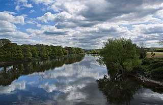
The River Ribble runs through North Yorkshire and Lancashire in Northern England. It starts close to the Ribblehead Viaduct in North Yorkshire, and is one of the few that start in the Yorkshire Dales and flow westwards towards the Irish Sea.
The Selgovae were a Celtic tribe of the late 2nd century AD who lived in what is now Kirkcudbrightshire and Dumfriesshire, on the southern coast of Scotland. They are mentioned briefly in Ptolemy's Geography, and there is no other historical record of them. Their cultural and ethnic affinity is commonly assumed to have been Brittonic.
Yorkshire is a historic county of England, centred on the county town of York. The region was first occupied after the retreat of the ice age around 8000 BC. During the first millennium AD it was inhabited by celtic Britons and occupied by Romans, Angles and Vikings. The name comes from "Eborakon" an old Brythonic name which probably derives from "Efor" or "the place of the yew-trees." Many Yorkshire dialect words and aspects of pronunciation derive from old Norse due to the Viking influence in this region. The name "Yorkshire", first appeared in writing in the Anglo-Saxon Chronicle in 1065. It was originally composed of three sections called Thrydings, subsequently referred to as Ridings.

Mamucium, also known as Mancunium, is a former Roman fort in the Castlefield area of Manchester in North West England. The castrum, which was founded c. AD 79 within the Roman province of Roman Britain, was garrisoned by a cohort of Roman auxiliaries near two major Roman roads running through the area. Several sizeable civilian settlements containing soldiers' families, merchants and industry developed outside the fort. The area is a protected Scheduled Ancient Monument.

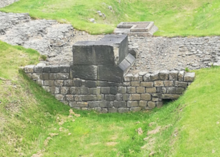
Piercebridge Roman Fort is a scheduled ancient monument situated in the village of Piercebridge on the banks of the River Tees in modern-day County Durham, England. There were Romans here from about AD 70 until at least the early 5th century. There was an associated vicus and bath house at Piercebridge, and another vicus and a villa south of the river at Cliffe. The Victorians used carved stones from this site when they built St Mary's church at Gainford. Part of the site is under Piercebridge village green.
Luguvalium was an ancient Roman city in northern Britain located within present-day Carlisle, Cumbria, and may have been the capital of the 4th-century province of Valentia. It was the northernmost city of the Roman Empire.

Castleshaw Roman fort was a castellum in the Roman province of Britannia. Although there is no evidence to substantiate the claim, it has been suggested that Castleshaw Roman fort is the site of Rigodunum, a Brigantian settlement. The remains of the fort are located on Castle Hill on the eastern side of Castleshaw Valley at the foot of Standedge but overlooking the valley. The hill is on the edge of Castleshaw in Greater Manchester. The fort was constructed in c. AD 79, but fell out of use at some time during the 90s. It was replaced by a smaller fortlet, built in c. 105, around which a civilian settlement grew. It may have served as a logistical and administrative centre, although it was abandoned in the 120s.

Vinovia or Vinovium was a Roman fort and settlement situated just over 1 mile (1.6 km) to the north of the town of Bishop Auckland on the banks of the River Wear in County Durham, England. The fort was the site of a hamlet until the late Middle Ages, but the modern-day village of Binchester is about 2 miles (3 km) to the east, near Spennymoor. The ruins are now known as the Binchester Roman Fort.
Condercum was a Roman fort on the site of the modern-day Condercum Estate in Benwell, a suburb of Newcastle upon Tyne, England. It was the third fort on Hadrian's Wall, about 6.8 miles east of Rudchester fort and only 2.4 miles west of Pons Aelius fort (Newcastle), and was situated on a hilltop 2 miles (3 km) to the west of the city.
Strutt's Park Roman Fort was a Roman fort in Strutt's Park, a suburb of Derby in Derbyshire, England. It was built around the year 50 and replaced, probably between the years 75 and 80, by a new fort at Little Chester on the opposite bank of the River Derwent.

The Derby Racecourse Roman settlement was the third settlement in Derby or Derventio which was a small town in the Roman province of Britannia. It lies 600m east of Derventio fort in Little Chester, on the outskirts of Derby, in the English county of Derbyshire. The Roman road from Derventio to Sawley on the River Trent passes the settlement. It is a scheduled National Monument.

Verterae was a Roman fort in the modern-day village of Brough, Cumbria, England. Occupied between the 1st and 5th centuries AD, it protected a key Roman road in the north of England. In the 11th century, Brough Castle was built on part of the site by the Normans. Archaeologists explored the remains during the 20th century, and it is now protected under UK law.

Derventio, sometimes described as Derventio Brigantium in order to distinguish it from other places called Derventio, was a Roman fort and settlement located beneath the modern town of Malton in North Yorkshire, England. The fort is positioned 18 miles north-east of Eboracum on the River Derwent.

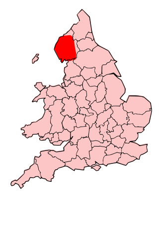
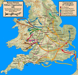
Brigantia is the land inhabited by the Brigantes, a British Celtic tribe which occupied the largest territory in ancient Britain. The territory of Brigantia which now forms Northern England and part of The Midlands covered the majority of the land between the River Tyne and the Humber estuary forming the largest Brythonic Kingdom in ancient Britain. It was recorded by Ptolemy in the 2nd century AD to extend sea to sea, from the Irish sea on the west coast to the North Sea in the east.

Lancaster Roman Fort, also known as Wery Wall, Galacum or Calunium, is the modern name given to ruined former Roman fort atop Castle Hill in Lancaster in North West England. The first castra was founded c. 80 AD within the Roman province of Britannia.

