
Adams County is a county in the U.S. state of Wisconsin. As of the 2010 census, the population was 20,875. Its county seat is Friendship. The county was created in 1848 and organized in 1853. Sources differ as to whether its name is in honor of the second President of the United States, John Adams, or his son, the sixth President, John Quincy Adams.

Washburn County is a county in the U.S. state of Wisconsin. It is named after Governor Cadwallader C. Washburn. As of the 2010 census, the population was 15,911. Its county seat is Shell Lake. The county was created in 1883.

Walworth County is a county located in the U.S. state of Wisconsin. As of the 2010 census, the population was 102,228. Its county seat is Elkhorn. The county was created in 1836 from Wisconsin Territory and organized in 1839. It is named for Reuben H. Walworth.

Sawyer County is a county in the U.S. state of Wisconsin. As of the 2010 census, the population was 16,557. Its county seat is Hayward.

Ozaukee County is a county in the U.S. state of Wisconsin. As of the 2010 census, the population was 86,395. Its county seat is Port Washington.

Oneida County is a county in the state of Wisconsin, United States. At the 2010 census, the population was 35,998. Its county seat is Rhinelander.

Kenosha County is a county in the southeastern corner of the U.S. state of Wisconsin. Its population in 2018 was estimated to be 169,290, making it the eighth most populous county in Wisconsin. The county is named after the county seat, Kenosha, the fourth largest city in Wisconsin.

Green Lake County is a county located in the U.S. state of Wisconsin. As of the 2010 census, the population was 19,051. Its county seat is Green Lake.

Burnett County is a county located in the U.S. state of Wisconsin. As of the 2010 census, the population was 15,457. Its county seat is Siren, with the majority of county governmental services located at the Burnett County Government Center. The county was created in 1856 and organized in 1865.

Barron County is a county located in the U.S. state of Wisconsin. As of the 2010 census, the population was 45,870. Its county seat is Barron. The county was created in 1859 and later organized in 1874.

Lake Arrowhead is an unincorporated community and a census-designated place (CDP) in the San Bernardino Mountains of San Bernardino County, California, surrounded by the San Bernardino National Forest, and surrounding the Lake Arrowhead Reservoir. Lake Arrowhead consists of 6 communities including Lake Arrowhead, Twin Peaks, Blue Jay, Cedar Glen, Skyforest, and Rimforest. The population of the CDP was estimated at 12,424 in the 2010 census. It was formerly called "Little Bear Lake", until around 1920, when a group from Los Angeles, the Arrowhead Lake Company, bought the lake and the land surrounding it, and changed its name to Arrowhead Lake.

Lake Arrowhead is a census-designated place (CDP) in the towns of Waterboro and Limerick in York County, Maine, United States. The population was 3,071 at the 2010 census. The CDP corresponds to the area covered by the Lake Arrowhead Community, a large subdivision begun in the 1960s which surrounds Lake Arrowhead, an artificial lake on the Little Ossipee River. The community is part of the Portland–South Portland–Biddeford, Maine Metropolitan Statistical Area.

Arrowhead Township is a township in Saint Louis County, Minnesota, United States. The population was 223 at the 2010 census.
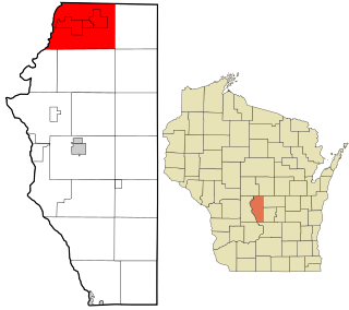
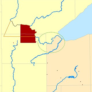
Rome is a town in Adams County in the U.S. state of Wisconsin. The population was 2,720 at the 2010 census. The census-designated places of Lake Arrowhead, Lake Camelot, and Lake Sherwood are located in the town. The unincorporated communities of New Rome and Rome are also located in the town.

Hartland is a village in Waukesha County, Wisconsin, along the Bark River, and is a suburb of Milwaukee. The population was 9,110 at the 2010 census.

The North Country National Scenic Trail, generally known as the North Country Trail or simply the N.C.T., is a footpath stretching over 4,600 miles (7,400 km) from Middlebury in central Vermont to Lake Sakakawea State Park in central North Dakota in the United States; connecting both the Long Trail with the Lewis and Clark Trail. Passing through the eight states of Vermont, New York, Pennsylvania, Ohio, Michigan, Wisconsin, Minnesota and North Dakota, it is the longest of the eleven National Scenic Trails authorized by Congress. As of early 2019, 3,129 miles of the trail is in place.
The Fond du Lac Indian Reservation is an Indian reservation in northern Minnesota near Cloquet in Carlton and Saint Louis counties. Off-reservation holdings are located across the state in Douglas County, in the northwest corner of Wisconsin. The total land area of these tribal lands is 153.8375 square miles (398.437 km2). It is the land-base for the Fond du Lac Band of Lake Superior Chippewa. Before the establishment of this reservation, the Fond du Lac Band of Lake Superior Chippewa were located at the head of Lake Superior, closer to the mouth of the Saint Louis River, where Duluth has developed.

The Arrowhead Region is located in the northeastern part of the U.S. state of Minnesota, so called because of its pointed shape. The predominantly rural region encompasses 10,635.26 square miles (27,545.2 km2) of land area and includes Carlton, Cook, Lake and Saint Louis counties. Its population at the 2000 census was 248,425 residents. Aitkin, Itasca, and Koochiching counties are also sometimes considered as part of the region. This would increase the land area to 18,221.97 square miles (47,194.7 km2) and the population to 322,073 residents.
Arrowhead High School is a high school located in Hartland, Wisconsin. Sitting on 117 acres (0.47 km2) of land, the school has two campuses, a north campus and a south campus. Juniors and seniors attend the north campus, while freshmen and sophomores attend the south campus.
An arrowhead is the point of an arrow. In archaeology, arrowheads and similar artifacts are known as projectile points.

