
Oroville East or Kelly Ridge is a census-designated place (CDP) in Butte County, California, United States. The population was 8,280 at the 2010 census, down from 8,680 at the 2000 census. Most citizens are dependent on the commerce of Oroville, and the vast majority of high school students in Kelly Ridge attend Las Plumas High School. The community of Kelly Ridge sits at Lake Oroville and offers direct access to boating, camping, fishing and a variety of water sports.
Meadow Vista is a census-designated place (CDP) in Placer County, California, United States. It is part of the Sacramento–Arden-Arcade–Roseville Metropolitan Statistical Area. The population was 3,217 at the 2010 census, up from 3,096 at the 2000 census.
Mohawk Vista is a census-designated place in Plumas County, California, United States. The population was 159 at the 2010 census, up from 121 at the 2000 census.

Morada is a census-designated place (CDP) in San Joaquin County, California, United States. The population was 3,166 at the 2020 census, down from 3,828 at the 2010 census.

Freedom is a census-designated place (CDP) in Santa Cruz County, California, United States. The population was 3,070 at the 2010 census.

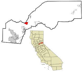
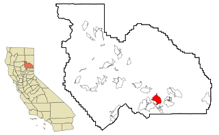
Poplar-Cotton Center is a census-designated place (CDP) in Tulare County, California, United States. The population was 2,470 at the 2010 census, up from 1,496 at the 2000 census.

Dade City North is a census-designated place (CDP) in eastern Pasco County, Florida, United States. The population was 3,319 at the 2000 census.

Puhi is a census-designated place (CDP) in Kauaʻi County, Hawaiʻi, United States. The population was 3,380 at the 2020 census, up from 1,186 at the 2000 census.

Paraje is a census-designated place (CDP) in Cibola County, New Mexico, United States. As of the 2010 census, the CDP population was 777.

Northampton is a hamlet and census-designated place (CDP) in Suffolk County, New York, United States on Long Island. The CDP population was 570 at the 2010 census.

Harrisville is a census-designated place (CDP) and village in the town of Burrillville in Providence County, Rhode Island, United States. The population was 1,605 at the 2010 census. Much of the community composes a historic district listed on the National Register of Historic Places. The village was named after nineteenth century manufacturer Andrew Harris. Previously, the village was named Rhodesville, after Captain William Rhodes, an eighteenth century privateer.

Llano Grande is a census-designated place (CDP) in Hidalgo County, Texas, United States. The population was 3,008 at the 2010 United States Census. It is part of the McAllen–Edinburg–Mission Metropolitan Statistical Area. Llano Grande means "Big Plain" in Spanish. Nearby Llano Grande State Park is popular with bird watchers and the supposed site of many ghost appearances, including the ghosts of historic figures in Texas history.

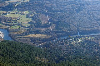
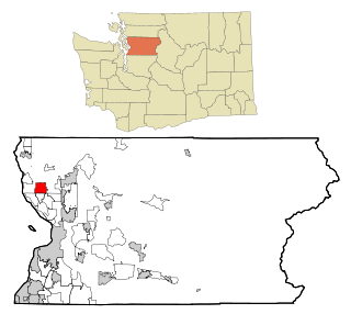
Riverbend is an unincorporated community and census-designated place (CDP) in King County, Washington, United States. The population was 2,123 at the 2020 census.

Marblemount is a census-designated place in Skagit County, Washington, United States. The population was 203 at the 2010 census. It is included in the Mount Vernon–Anacortes, Washington Metropolitan Statistical Area.
Rockport is a census-designated place (CDP) in Skagit County, Washington, United States. The population was 109 at the 2010 census. It is included in the Mount Vernon–Anacortes, Washington Metropolitan Statistical Area.

Canyon Creek is a census-designated place (CDP) in Snohomish County, Washington, United States. The population was 3,445 at the 2020 census, up from 3,200 at the 2010 census. Prior to the 2010 census, the CDP was known as Jordan Road-Canyon Creek.
Lake Goodwin is a former census-designated place (CDP) in Snohomish County, Washington, United States. The population was 3,354 at the 2000 census. The CDP was discontinued at the 2010 census.

Lochsloy is a census-designated place (CDP) in Snohomish County, Washington, United States. The population was 2,806 at the 2020 census, up from 2,533 at the 2010 census.

Satus is a census-designated place (CDP) in Yakima County, Washington, United States, located on the eastern corner of the Yakama Indian Reservation. The population was 746 at the 2000 census. It is southwest from the Toppenish National Wildlife Refuge. The community was not recognized in the 2010 census. The area was first settled and established as a post office location in 1890.

Winthrop is a census-designated place (CDP) comprising the primary settlement in the town of Winthrop in Kennebec County, Maine, United States. The population was 2,650 at the 2010 census, out of 6,092 in the town of Winthrop as a whole.

