Related Research Articles

Okmulgee is a city in, and the county seat of, Okmulgee County, Oklahoma. The name is from the Mvskoke word okimulgee, which means "boiling waters". The site was chosen because of the nearby rivers and springs. Okmulgee is 38 miles south of Tulsa and 13 miles north of Henryetta via US-75.
Copan is a town in Washington County, Oklahoma, United States. The population was 733 at the 2010 census, a decline of 7.9 percent from the figure of 796 recorded in 2000.

The Lake of the Arbuckles is a reservoir located in southern Oklahoma, 8 miles (13 km) southwest of Sulphur in Murray County. The lake covers 2,350 acres (950 ha) and is a principal water supply reservoir for the city of Ardmore, some 30 mi (48 km) to the southwest. It also supplies water to the cities of Sulphur, Davis, Wynnewood and a large oil refinery near Wynnewood. The lake also provides flood control, fish and wildlife habitat and recreation opportunities.
Great Salt Plains Lake is a reservoir located within the Salt Plains National Wildlife Refuge in Alfalfa County, Oklahoma in the United States named because of the salt flats in the area and for the Salt Fork Arkansas River, which is dammed to form the lake. It is notable for the variety of birds that are attracted to Ralstin Island and also for the selenite crystals that can be collected along the shoreline. Recent droughts, most notably that of 2011, have had an adverse effect on the future of the lake.

Fort Cobb Reservoir is a reservoir located in Caddo County in the U.S. state of Oklahoma. It impounds the waters of Cobb Creek, Lake Creek, and Willow Creek. The lake covers approximately 4,000 acres (16 km2) of water and 45 mi (72 km) of shoreline. Its drainage area is 285 square miles (740 km2). It was constructed in 1958. The towns of Carnegie, Fort Cobb, and Eakly are located nearby.
Konawa Reservoir is a reservoir located in Seminole County, Oklahoma. The lake covers approximately 1,350 acres (5.5 km2) and has a capacity of 23,000 acre-feet (28,000,000 m3). It is owned by Oklahoma Gas and Electric (OG&E) Company. and was constructed in 1968-70, to provide cooling for a nearby gas-fired electric power generation plant. It impounds Jumper Creek, about 2 miles (3.2 km) east of the city of Konawa, Oklahoma.
Lake Thunderbird is a reservoir located in Norman, Oklahoma. The lake was constructed between 1962 and 1965 for the purpose of providing municipal water to the nearby communities of Del City, Midwest City and Norman. It is formed by an earthfill embankment (dam) 7,300 feet (2,200 m) long and up to 144 feet (44 m) high on the Little River. In addition to being a source for drinking water, Lake Thunderbird's secondary uses include numerous recreational activities.

The Spring River is a 129-mile-long (208 km) waterway located in southwestern Missouri, southeastern Kansas, and northeastern Oklahoma.

Wilson Lake is a reservoir in the U.S. state of Kansas, on the border of Russell County and Lincoln County. Built and managed by the U.S. Army Corps of Engineers for flood control, it is also used for wildlife management and recreation. Several parks are located along its shoreline, including Wilson State Park.

Perry Lake is a US Army Corps of Engineers operated reservoir in northeast Kansas. Its primary purposes are flood control, water reserve for nearby areas and regional recreation. The lake is approximately 11,150 acres (45 km²) in size, with over 160 miles (260 km) of shoreline. Perry Lake's full multi-purpose pool elevation is 891.5 feet (271.7 m) above sea level. Perry Lake is located about 40 miles (64 km) west of Kansas City, just northwest of Lawrence, Kansas. Its close proximity to Kansas City, Lawrence, and the state capitol, Topeka, make it a very popular destination, with the nickname "Paradise on the Plains".

Lake Altus-Lugert, also known as Lake Altus, Lake Lugert, Lake Lugert-Altus, and Lugert Lake, is a reservoir located on the North Fork Red River, about 17 miles (27 km) north of Altus, Oklahoma on the former site of the town of Lugert, Oklahoma. The river is the boundary between Greer County and Kiowa County, Oklahoma. The lake is used for fishing, boating, swimming, and irrigation. This is also the principal water supply for Altus.

Black Mesa State Park is an Oklahoma state park in Cimarron County, near the western border of the Oklahoma panhandle and New Mexico. The park is located about 15 miles (24 km) away from its namesake, Black Mesa, the highest point in Oklahoma. The mesa was named for the layer of black lava rock that coats it.

Waconda Lake, also known as Glen Elder Reservoir, is a reservoir in Mitchell County and Osborne County, Kansas, United States. Built and managed by the U.S. Bureau of Reclamation for flood control and irrigation, it is also used for recreation. Glen Elder State Park is located on its north shore.

Lake Yahola is a reservoir in Tulsa, Oklahoma. The reservoir was completed in 1924. Its primary purpose is to store raw water for treatment and distribution. This city-owned, 2-billion-US-gallon (7,600,000 m3), concrete-lined lake is an integral part of the Tulsa water supply, and receives water by pipeline from Lake Spavinaw. It is located in Mohawk Park, adjacent to the Mohawk Water Treatment Plant.
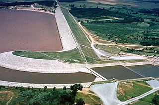
Copan Dam is a dam in Washington County, Oklahoma, in the northeastern part of the state.
Raymond Gary Lake is a reservoir in southeastern Oklahoma, United States, one mile east of the town of Fort Towson in Choctaw County. It was constructed on Gates Creek in 1956 by the Oklahoma Department of Wildlife Conservation.
Lake Elmer is a reservoir in Kingfisher County, Oklahoma that is owned by the Oklahoma Department of Wildlife Conservation. The nearest town is Kingfisher, about 4 miles (6.4 km) southeast of the lake. Constructed in 1962, it was completely drained in 1978 for deepening the shoreline and constructing fishing jetties. It was reimpounded and restocked with fish, after a fish kill in 1979. It has a surface area of 60 acres (24 ha) and a shoreline of 3.4 miles (5.5 km). Its elevation is 1,119 feet (341 m). The latitude and longitude are 35.8798, -97.9878. It has an average depth of 6 feet (1.8 m) and a maximum depth of 18 feet (5.5 m).
South Carrizo Creek forms either just west of the Oklahoma line in New Mexico, or east inside Oklahoma to the northwest of Wheeless, Oklahoma. It is intermittent. It travels generally northeast through Black Mesa State Park where it is impounded to form Lake Carl Etling, before being joined by Willow Creek and continuing northeast to flow into the Cimarron River.
Carrizo Creek forms in Arizona north of Cibecue, before flowing generally southeast, being joined by Corduroy Creek around the town of Carrizo, and continuing generally south to join the Salt River.
References
- ↑ "Lake Carl Etling". Geographic Names Information System . United States Geological Survey, United States Department of the Interior . Retrieved 2021-07-23.
- ↑ "Lake Carl Etling, Oklahoma". Google Maps. Retrieved July 21, 2021.
- 1 2 3 4 5 "Lake Carl Etling". TravelOK.com. Retrieved July 21, 2021.
- ↑ "Tiger Muskie Stocking in Lake Carl Etling" (PDF). U.S. Fish and Wildlife Service, January 2016. Retrieved July 14, 2021.
- ↑ Leisure and Sports Review (LASR). "Lake Carl G. Etling, OK." Retrieved December 4, 2013.
- ↑ "Carl Etling | Oklahoma Department of Wildlife Conservation". www.wildlifedepartment.com. Retrieved 17 September 2023.
36°50′54″N102°52′31″W / 36.84833°N 102.87528°W
| | This Oklahoma state location article is a stub. You can help Wikipedia by expanding it. |