Lake Kiowa, Texas

Last updated
Lake Kiowa, Texas
Cooke County LakeKiowa.svg
Coordinates: 33°33′59″N97°0′27″W / 33.56639°N 97.00750°W / 33.56639; -97.00750
Country United States
State Texas
County Cooke
Area
  Total3.8 sq mi (9.8 km2)
  Land3.0 sq mi (7.7 km2)
  Water0.8 sq mi (2.1 km2)
Elevation
709 ft (216 m)
Population
 (2020)
  Total2,254
  Density600/sq mi (230/km2)
Time zone UTC-6 (Central (CST))
  Summer (DST) UTC-5 (CDT)
ZIP code
76240
Area code 940
FIPS code 48-40624 [1]
GNIS feature ID1852719 [2]
Website www.lakekiowatx.com

Lake Kiowa is a census-designated place (CDP) in Cooke County, Texas, United States, the majority of which consists of the gated community of the same name.

Contents

The population was 1,906 at the 2010 census. [3]

Geography

Lake Kiowa is a private residential community located in southeastern Cooke County at 33°33′59″N97°0′27″W / 33.56639°N 97.00750°W / 33.56639; -97.00750 (33.566497, -97.007479), [4] around the lake of the same name. The lake is an impoundment on Indian Creek, part of the Trinity River watershed. The community is 10 miles (16 km) southeast of Gainesville, the Cooke County seat.

According to the United States Census Bureau, the CDP has a total area of 3.8 square miles (9.8 km2), of which 3.0 square miles (7.7 km2) is land and 0.81 square miles (2.1 km2), or 21.07%, is water. [3]

Demographics

2020 census

Lake Kiowa racial composition [5]
(NH = Non-Hispanic) [lower-alpha 1]
RaceNumberPercentage
White (NH)2,05591.17%
Black or African American (NH)150.67%
Native American or Alaska Native (NH)231.02%
Asian (NH)100.44%
Pacific Islander (NH)20.09%
Mixed/Multi-Racial (NH)883.9%
Hispanic or Latino 612.71%
Total2,254

As of the 2020 United States census, there were 2,254 people, 1,070 households, and 839 families residing in the CDP.

2000 census

As of the census [1] of 2000, there were 1,883 people, 861 households, and 661 families residing in the CDP. The population density was 628.1 inhabitants per square mile (242.5/km2). There were 1,064 housing units at an average density of 354.9 per square mile (137.0/km2). The racial makeup of the CDP was 97.45% White, 0.11% African American, 0.53% Native American, 0.37% Asian, 0.48% from other races, and 1.06% from two or more races. Hispanic or Latino of any race were 1.75% of the population.

There were 861 households, out of which 14.4% had children under the age of 18 living with them, 72.7% were married couples living together, 2.7% had a female householder with no husband present, and 23.2% were non-families. 21.0% of all households were made up of individuals, and 14.2% had someone living alone who was 65 years of age or older. The average household size was 2.19 and the average family size was 2.49.

In the CDP, the population was spread out, with 13.6% under the age of 18, 2.6% from 18 to 24, 14.0% from 25 to 44, 35.4% from 45 to 64, and 34.4% who were 65 years of age or older. The median age was 59 years. For every 100 females, there were 93.1 males. For every 100 females age 18 and over, there were 92.3 males.

The median income for a household in the CDP was $55,430, and the median income for a family was $66,250. Males had a median income of $44,531 versus $27,750 for females. The per capita income for the CDP was $28,354. About 1.7% of families and 5.4% of the population were below the poverty line, including 10.4% of those under age 18 and 1.5% of those age 65 or over.

Community government and amenities

Lake Kiowa is governed by the Lake Kiowa Property Owners Association, which is owned by the property owners themselves as the community is almost totally built out (all lots previously owned by the developers were sold as of 2017; the only vacant lots remaining are owned by private individuals).

The Association is led by a nine-member elected board of directors, with each director serving a three-year term. The terms are offset with three directors up for election each year. The Association maintains the community's amenities as well as its roads (the community's main road, Kiowa Drive, loops around the lake and crosses over its dam).

The Association provides private security, limited to writing speeding/parking tickets and enforcing community rules. Police protection is provided by the Cooke County Sheriff's Department and, to a lesser extent, the nearby Gainesville Police Department. Fire and emergency services are provided by the Indian Creek Volunteer Fire Department which serves Lake Kiowa and the surrounding area.

The Lake Kiowa Special Utility District maintains the water supply. Trash pickup is provided by the Association through a private contractor (recycling is no longer offered as of 2018, outside of aluminum can donation sites for the local Kiwanis Club). Sewer service is not available; homes must install and maintain an operative septic system.

The Callisburg Independent School District serves students residing in Lake Kiowa.

Amenities

The Association owns the amenities offered by the community, which are centered around its namesake lake (a private 563-acre (2.28 km2) lake). The lake is large enough for skiing, tubing, and other controlled boating activities, though wake boats must disable their ballast system to prevent damage to private boat docks and sea walls. Fishing is permitted and abundant fish reside in the lake; the Lake Kiowa Anglers and Conservation Club maintains the small and large fishing areas provided.

In addition, the Association also operates a private 18-hole golf course. Two different beach areas offer swimming, volleyball, tennis, and other opportunities. Each beach has picnic areas and a large pavilion is located at the Lodge (the community clubhouse and restaurant/bar). A nine-hole disc golf course is also available.

Related Research Articles

<span class="mw-page-title-main">Cooke County, Texas</span> County in Texas, United States

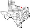
Cooke County is a county in the U.S. state of Texas. At the 2020 census, its population was 41,668. The county seat is Gainesville. The county was founded in 1848 and organized the next year. It is named for William Gordon Cooke, a soldier during the Texas Revolution. It is a part of the Texoma region.

<span class="mw-page-title-main">Kendall West, Florida</span> Census-designated place in Florida

Kendall West is a census-designated place and unincorporated community in Miami-Dade County, Florida, west of the Florida Turnpike. It is located in the Miami metropolitan area of South Florida. The population was 36,536 at the 2020 census.

<span class="mw-page-title-main">Palm Springs North, Florida</span> Census-designated place in Florida

Palm Springs North is an unincorporated community and census-designated place (CDP) in Miami-Dade County, Florida, United States. It is part of the Miami metropolitan area of South Florida. The population was 5,030 at the 2020 census.

<span class="mw-page-title-main">Sunset, Florida</span> Census-designated place in Florida

Sunset is a census-designated place (CDP) in Miami-Dade County, Florida, United States. It is part of the Miami metropolitan area of South Florida. The population was 15,912 at the 2020 census. The U.S. Postal Service uses the ZIP Codes of 33173 and 33183 for Sunset.

<span class="mw-page-title-main">Three Lakes, Florida</span> Census-designated place in Florida

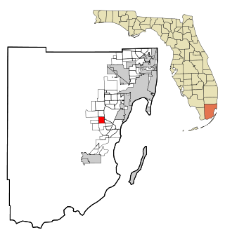
Three Lakes is a census-designated place (CDP) and planned community in Miami-Dade County, Florida, United States. It is part of the Miami metropolitan area of South Florida. The population was 16,540 at the 2020 census, up from 15,047 in 2010.

<span class="mw-page-title-main">Westwood Lakes, Florida</span> Census-designated place in Florida

Westwood Lakes is a census-designated place and unincorporated community of Miami-Dade County, Florida, United States. It is part of the Miami metropolitan area of South Florida. The population was 11,373 at the 2020 census.

<span class="mw-page-title-main">Channel Lake, Illinois</span> Census-designated place in Illinois, United States

Channel Lake is an unincorporated community and census-designated place (CDP) in Antioch Township, Lake County, Illinois, United States. Per the 2020 census, the population was 1,581.

Forest Lake is an unincorporated community and census-designated place (CDP) in Ela Township of Lake County, Illinois, United States. It is about 35 miles (56 km) northwest of downtown Chicago. Per the 2020 census, the population was 1,784. The community was founded in 1935 as a vacation community for Chicago residents.

Fox Lake Hills is an unincorporated community and census-designated place (CDP) in Lake Villa Township, Lake County, Illinois, United States. Per the 2020 census, the population was 2,684.

Lake Catherine is an unincorporated community and census-designated place (CDP) in Lake County, Illinois, United States. Per the 2020 census, the population was 1,279.

Long Lake is an unincorporated community and census-designated place (CDP) in Lake County, Illinois, United States. Per the 2020 census, the population was 3,663.

<span class="mw-page-title-main">Koontz Lake, Indiana</span> Census-designated place in Indiana, United States

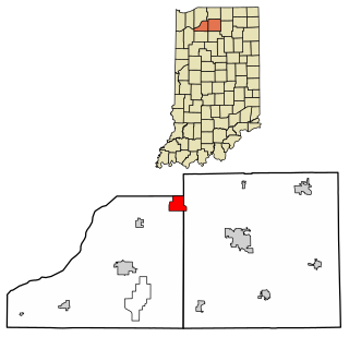
Koontz Lake is an unincorporated community and census-designated place in Starke and Marshall counties in Indiana. The population was 1,667 at the 2020 census.

<span class="mw-page-title-main">Lost Lake Woods, Michigan</span> Census-designated place & unincorporated community in Michigan, United States

Lost Lake Woods is an unincorporated community and census-designated place (CDP) in Alcona County in the U.S. state of Michigan. The population was 367 at the 2020 census. It is located within Alcona Township.

<span class="mw-page-title-main">Arnold, Minnesota</span> Census-designated place in Minnesota, US

Arnold is a former census-designated place (CDP), which was located in Rice Lake, Saint Louis County, Minnesota, United States. The population was 2,960 at the 2010 census. The census-designated place of Arnold was located entirely within the former Rice Lake Township, adjacent to the north side of the city of Duluth. Rice Lake Township was incorporated as the city of Rice Lake on October 22, 2015, thus rendering the census-designated place of Arnold to no longer exist.

<span class="mw-page-title-main">Collings Lakes, New Jersey</span> Populated place in Atlantic County, New Jersey, US

Collings Lakes is an unincorporated community and census-designated place (CDP) located within Buena Vista Township in Atlantic County, in the U.S. state of New Jersey. As of the 2010 United States Census, the CDP's population was 1,706.

<span class="mw-page-title-main">Shawnee Hills, Greene County, Ohio</span> Census-designated place in Ohio, United States

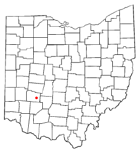
Shawnee Hills is a census-designated place (CDP) in Greene County, Ohio, United States. Shawnee Hills consists of a planned community centered on the 250-acre (1.0 km2) Shawnee Lake. The population was 2,230 at the 2020 census. It is part of the Dayton Metropolitan Statistical Area, and should not be confused with the incorporated village of Shawnee Hills in Delaware County.

<span class="mw-page-title-main">Treasure Lake, Pennsylvania</span> Census-designated place in Pennsylvania, United States

Treasure Lake is a census-designated place (CDP) in Clearfield County, Pennsylvania, United States. The population was 5,460 at the 2020 census. Treasure Lake is a semi-private, gated community centered around its namesake.

<span class="mw-page-title-main">Cameron Park, Texas</span> CDP in Texas, United States

Cameron Park is a census-designated place (CDP) in Cameron County, Texas, United States. The population was 6,099 at the 2020 census. It is part of the Brownsville–Harlingen Metropolitan Statistical Area.

<span class="mw-page-title-main">Timber Lakes, Utah</span> CDP in Utah, United States

Timber Lakes is a census-designated place (CDP) in Wasatch County, Utah, United States. The population was 607 at the 2010 census, up from 289 in 2000.

<span class="mw-page-title-main">Alafaya, Florida</span> Census-designated place in Florida, United States

Alafaya is a census-designated place and unincorporated area in Orange County, Florida, United States. The population was 92,452 at the 2020 US census. It is part of the Orlando–Kissimmee–Sanford, Florida Metropolitan Statistical Area. It is most known for being near the University of Central Florida, Avalon Park and Waterford Lakes.

References

  1. 1 2 "U.S. Census website". United States Census Bureau . Retrieved 2008-01-31.
  2. "US Board on Geographic Names". United States Geological Survey. 2007-10-25. Retrieved 2008-01-31.
  3. 1 2 "Geographic Identifiers: 2010 Census Summary File 1 (G001): Lake Kiowa CDP, Texas". U.S. Census Bureau, American Factfinder. Archived from the original on February 13, 2020. Retrieved August 5, 2015.
  4. "US Gazetteer files: 2010, 2000, and 1990". United States Census Bureau. 2011-02-12. Retrieved 2011-04-23.
  5. "Explore Census Data". data.census.gov. Retrieved 2022-05-22.
  6. https://www.census.gov/ [ not specific enough to verify ]
  7. "About the Hispanic Population and its Origin". www.census.gov. Retrieved 18 May 2022.
  1. Note: the US Census treats Hispanic/Latino as an ethnic category. This table excludes Latinos from the racial categories and assigns them to a separate category. Hispanics/Latinos can be of any race. [6] [7]