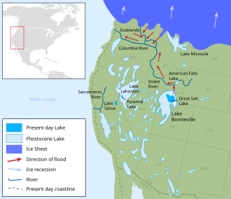
The Great Basin is the largest area of contiguous endorheic watersheds – those with no outlets – in North America. It spans nearly all of Nevada, much of Utah, and portions of California, Idaho, Oregon, Wyoming, and Baja California, Mexico. It is noted for both its arid climate and the basin and range topography that varies from the North American low point at Badwater Basin in Death Valley to the highest point of the contiguous United States, less than 100 miles (160 km) away at the summit of Mount Whitney. The region spans several physiographic divisions, biomes, ecoregions, and deserts.

The Black Rock Desert is a semi-arid region of lava beds and playa, or alkali flats, situated in the Black Rock Desert–High Rock Canyon Emigrant Trails National Conservation Area, a silt playa 100 miles (160 km) north of Reno, Nevada that encompasses more than 300,000 acres (120,000 ha) of land and contains more than 120 miles (200 km) of historic trails. It is in the northern Nevada section of the Great Basin with a lakebed that is a dry remnant of Pleistocene Lake Lahontan.

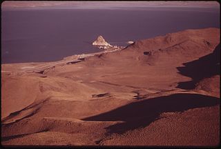
Pyramid Lake is the geographic sink of the basin of the Truckee River, 40 mi (64 km) northeast of Reno, Nevada, United States.
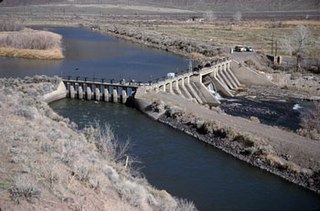
Derby Dam is a diversion dam built from 1903 to 1905 on the Truckee River, located about 20 miles (32 km) east of Reno in Storey and Washoe counties in Nevada, United States. It diverts water into the Truckee Canal that would otherwise enter Pyramid Lake. The canal feeds Lake Lahontan reservoir in the Carson River watershed, where it is used for irrigation.
The cui-ui is a large sucker fish endemic to Pyramid Lake and, prior to its desiccation in the 20th century, Winnemucca Lake in northwestern Nevada. It feeds primarily on zooplankton and possibly on nanoplankton. The maximum size of male cui-ui is approximately 53 cm (21 in) and 1.6 kg (3.5 lb), while females reach approximately 64 cm (25 in) and 2.7 kg (6.0 lb). The life span of cui-ui is typically about forty years, but the fish do not reach sexual maturity until at least age eight. The cui-ui is an endangered species, and one of the few surviving members of its genus.

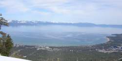
The Truckee River is a river in the U.S. states of California and Nevada. The river flows northeasterly and is 121 miles (195 km) long. The Truckee is the sole outlet of Lake Tahoe and drains part of the high Sierra Nevada, emptying into Pyramid Lake in the Great Basin. Its waters are an important source of irrigation along its valley and adjacent valleys.

Carson Sink is a playa in the northeastern portion of the Carson Desert in present-day Nevada, United States of America, that was formerly the terminus of the Carson River. Today the sink is fed by drainage canals of the Truckee-Carson Irrigation District. The southeastern fringe of the sink, where the canals enter, is a wetland of the Central Basin and Range ecoregion.

The Carson River is a northwestern Nevada river that empties into the Carson Sink, an endorheic basin. The main stem of the river is 131 miles (211 km) long although the addition of the East Fork makes the total length 205 miles (330 km), traversing five counties: Alpine County in California and Douglas, Storey, Lyon, and Churchill Counties in Nevada, as well as the Consolidated Municipality of Carson City, Nevada. The river is named for Kit Carson, who guided John C. Frémont's expedition westward up the Carson Valley and across Carson Pass in winter, 1844. The river made the National Priorities List (NPL) on October 30, 1990 as the Carson River Mercury Superfund site (CRMS) due to investigations that showed trace amounts of mercury in the wildlife and watershed sediments.

The Walker River is a river in west-central Nevada in the United States, approximately 62 miles (100 km) long. Fed principally by snowmelt from the Sierra Nevada mountains of California, it drains an arid portion of the Great Basin southeast of Reno and flows into the endorheic basin of Walker Lake. The river is an important source of water for irrigation in its course through Nevada; water diversions have reduced its flow such that the level of Walker Lake has fallen 160 feet (49 m) between 1882 and 2010. The river was named for explorer Joseph Reddeford Walker, a mountain man and experienced scout who is known for establishing a segment of the California Trail.

The cutthroat trout(Oncorhynchus clarkii) is a fish species of the family Salmonidae native to cold-water tributaries of the Pacific Ocean, Rocky Mountains, and Great Basin in North America. As a member of the genus Oncorhynchus, it is one of the Pacific trout, a group that includes the widely distributed rainbow trout. Cutthroat trout are popular gamefish, especially among anglers who enjoy fly fishing. The common name "cutthroat" refers to the distinctive red coloration on the underside of the lower jaw. The specific name clarkii was given to honor explorer William Clark, coleader of the Lewis and Clark Expedition.
The Pyramid Lake Paiute Tribe Reservation is a United States reservation in northwestern Nevada, approximately 35 miles (56 km) northeast of Reno, in Washoe, Storey, and Lyon counties.

Lahontan cutthroat trout is the largest subspecies of cutthroat trout, and the state fish of Nevada. It is one of three subspecies of cutthroat trout that are listed as federally threatened.
The tui chub is a cyprinid fish native to western North America. Widespread in many areas, it is an important food source for other fish, including the cutthroat trout.
The DSSAM Model is a computer simulation developed for the Truckee River to analyze water quality impacts from land use and wastewater management decisions in the Truckee River Basin. This area includes the cities of Reno and Sparks, Nevada as well as the Lake Tahoe Basin. The model is historically and alternatively called the Earth Metrics Truckee River Model. Since original development in 1984-1986 under contract to the U.S. Environmental Protection Agency (EPA), the model has been refined and successive versions have been dubbed DSSAM II and DSSAM III. This hydrology transport model is based upon a pollutant loading metric called Total maximum daily load (TMDL). The success of this flagship model contributed to the Agency's broadened commitment to the use of the underlying TMDL protocol in its national policy for management of most river systems in the United States.
The Upper Truckee River is a stream that flows northward from the western slope of Red Lake Peak in Alpine County, California to Lake Tahoe via the Truckee Marsh in South Lake Tahoe, California. The river flows northeasterly and is 23 miles (37 km) long. It is Lake Tahoe's largest tributary.

Paiute cutthroat trout is one of fourteen subspecies of cutthroat trout. Paiute Cutthroat are native only to Silver King Creek, a headwater tributary of the Carson River in the Sierra Nevada, in California. This subspecies is named after the indigenous Northern Paiute peoples.
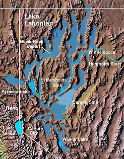
The Lahontan Valley is a basin in Churchill County, Nevada, United States. The valley is a landform of the central portion of the prehistoric Lake Lahontan's lakebed of 20,000-9,000 years ago. The valley and the adjacent Carson Sink represent a small portion of the lake bed. Humboldt Lake is to the valley's northeast. Pyramid Lake is west. Walker Lake is to the south. The valley is part of the larger Great Basin Desert, however during the California Gold Rush was valley often called the Forty Mile Desert.

The Carson Desert is a desert in the Lahontan Basin and the desert valley of Churchill County, Nevada (U.S.), which receives an average 5 inches (130 mm) annual precipitation. The desert is the low valley area between the adjacent mountain ranges, while the larger watershed includes the interior slopes of the demarcating ranges. The desert was inundated by Lake Lahontan during the Pleistocene, and the watershed became part of Nevada's Conservation Security Program in 2005.

Trout Creek is a small tributary of the Truckee River draining about 5.1 square miles (13 km2) along the eastern crest of the Sierra Nevada. It originates east of Donner Ridge and north of Donner Lake in the Tahoe–Donner Golf Course and flows through the town of Truckee, California, to its confluence with the Truckee River in Nevada County, California, just west of Highway 267.