Related Research Articles

Mayes County is a county located in the U.S. state of Oklahoma. As of the 2010 census, the population was 41,259. Its county seat is Pryor Creek. Named for Samuel Houston Mayes, Principal Chief of the Cherokee Nation from 1895 to 1899, it was originally created at the Sequoyah Convention in August 1905.

The Lake of the Arbuckles is a reservoir located in southern Oklahoma, 8 miles (13 km) southwest of Sulphur in Murray County. The lake covers 2,350 acres (950 ha) and is a principal water supply reservoir for the city of Ardmore, some 30 mi (48 km) to the southwest. It also supplies water to the cities of Sulphur, Davis, Wynnewood and a large oil refinery near Wynnewood. The lake also provides flood control, fish and wildlife habitat and recreation opportunities.
Lake Overholser is a reservoir within the city limits of Oklahoma City, Oklahoma. Lake Overholser is formed by Overholser Dam on the North Canadian River in Oklahoma County, Oklahoma. The lake is 2.9 miles (4.7 km) west of Bethany. Lake Overholser is named after Ed Overholser who was the 16th Mayor of the City of Oklahoma City.
Lake Thunderbird is a reservoir located in Norman, Oklahoma. The lake was constructed between 1962 and 1965 for the purpose of providing municipal water to the nearby communities of Del City, Midwest City and Norman. It is formed by an earthfill embankment (dam) 7,300 feet (2,200 m) long and up to 144 feet (44 m) high on the Little River. In addition to being a source for drinking water, Lake Thunderbird's secondary uses include numerous recreational activities.

Grand Lake o' the Cherokees is situated in Northeast Oklahoma, nestled in the foothills of the Ozark Mountain Range. It is often simply called Grand Lake. It is administered by the Grand River Dam Authority (GRDA).
Lake Ellsworth is a lake in Caddo and Comanche counties in the state of Oklahoma in the United States. It was built by the City of Lawton, Oklahoma in 1962, primarily to serve as a water supply source for Lawton and the surrounding area. The nearest community is Elgin, Oklahoma.
Black Bear Creek is a 116-mile-long (187 km) creek in northern Oklahoma. Black Bear Creek drains an area of 538 square miles (1,390 km2) in Garfield County, Noble County and Pawnee County, Oklahoma. It takes on a red color from the red clay of this area. The creek gets its name from the black bear. Though the area is outside of the range of the black bear, sightings have been rumored.

Optima Lake was built to be a reservoir in Texas County, Oklahoma. The site is located just north of Hardesty and east of Guymon in the Oklahoma Panhandle.

Lake Oologah is a reservoir in northeastern Oklahoma. It is located near the towns of Oologah, Nowata, and Claremore. The lake has a surface of 29,500 acres (119 km2) of water and 209 miles (336 km) of shoreline with 11 lake-side parks. The water storage capacity is rated as 552,210 acre feet (681,140,000 m3). The lake is formed along the Verdigris River, and is a source of water for the Tulsa Metropolitan Area. The purpose of the dam and lake is flood control, water supply, navigation, recreation, and fish and wildlife.

Lake Lawtonka is a lake in Comanche County in the state of Oklahoma in the United States.
The Grand River Dam Authority (GRDA) is a non-profit Oklahoma agency created to control, develop, and maintain the Grand River waterway. It was created by the Oklahoma state legislature in 1935, and is headquartered in Vinita, Oklahoma. GRDA was designed to be self-funding from the sales of electricity and water. The state of Oklahoma was to provide no funding from taxes. The Authority was authorized to issue revenue bonds to fund large-scale capital investments.
William Rea Holway, commonly known as W. R. Holway, was an American civil engineer who became prominent in Oklahoma. He is best known for his work on major water supply projects for the city of Tulsa, and on the Pensacola Dam at Grand Lake o' the Cherokees.
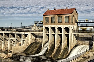
The Pensacola Dam, also known as the Grand River Dam, is a multiple-arch buttress dam on the Grand River in-between Disney and Langley in the U.S. state of Oklahoma. The dam is operated by the Grand River Dam Authority and creates Grand Lake o' the Cherokees. After decades of vision and planning, it was constructed between 1938 and 1940 for the purposes of hydroelectric power generation, flood control and recreation. It is Oklahoma's first hydroelectric power plant and is referred to as the longest multiple-arch dam in the world.

The Spavinaw Water Project was a water project to provide water for Tulsa, Oklahoma.

Lake Hudson, also known as Markham Ferry Reservoir, is a man-made reservoir in Mayes County, Oklahoma, United States, about 2 miles (3.2 km) northwest of Locust Grove, Oklahoma and 8 miles (13 km) southeast of Pryor, Oklahoma. It was created by the completion of the Robert S. Kerr Dam on the Grand River in 1964. It is managed by the Grand River Dam Authority (GRDA).
The Salina Pumped Storage Project is a 260-megawatt (350,000 hp) pumped-storage power station near Salina, Oklahoma. It is owned and operated by the Grand River Dam Authority (GRDA). Its construction was in response to growing power demands and a lack of dam sites on the Grand River. The first phase was completed in 1968 and the second in 1971. The upper reservoir for the power station is Lake W. R. Holway which was built on Saline Creek and the lower reservoir is Lake Hudson on the Grand River. During periods of lower power demand, water is pumped from Lake Hudson to Lake Holway and released back down through the pump-generators during periods of high energy demand.
Boomer Lake is located in the city of Stillwater, Oklahoma, United States, and was completed in 1925. The lake, as an artificial reservoir created by damming Stillwater Creek, serves several purposes such as cooling the local power plant and providing entertainment and recreation. Boomer Lake has a surface area of 251 acres (1,020,000 m2), watershed area of 8,954 acres (36,240,000 m2), shoreline length of 8.6 miles (13.8 km), shoreline development ratio of 4.17, and mean depth of 9.7 feet (3.0 m). The lake was designed to contain 3,600 acre feet (4,400,000 m3) in 1932, but in 2010 the capacity was reportedly only 1,484 acre feet (1,830,000 m3).
Lake Lone Chimney owned by the Tri-County Development Authority, is in Pawnee County, Oklahoma, east of Glencoe. The lake, whose dam is also known as Lower Black Bear Creek Watershed Dam 19M, also extends into southern Payne County, Oklahoma. It was built in 1980 by the Tri-County Development Authority, Pawnee County Conservancy District and the Black Bear Conservancy District, assisted by the Oklahoma Conservation Commission and the USDA Natural Resources Conservation Service (NRCS) Watershed Protection and Flood Protection Program.
Lloyd Church Lake is a reservoir located south of the city of Wilburton, Oklahoma on a tributary of the Fourche Maline river. The lake is supported by an earthen dam and was constructed in 1964.
References
- ↑ "Oklahoma Fishing Guides Website: Lake W. R. Holway." Retrieved September 19, 2011.
- ↑ Outdoors OK, W. R. Holway Reservoir, Oklahoma
- ↑ "Hydrographic Survey of W. R. Holway Reservoir". Oklahoma Water Resources Board. August 12, 2009.
- ↑ http://www.oar.state.ok.us/viewhtml/300_35-7-10.htm