
The Willamette Valley AVA is an American Viticultural Area which lies in the Willamette Valley of Oregon. The AVA is the wine growing region which encompasses the drainage basin of the Willamette River. It stretches from the Columbia River in the north to just south of Eugene in the south, where the Willamette Valley ends; and from the Oregon Coast Range in the west to the Cascade Mountains in the east. At 5,360 square miles (13,900 km2), it is the largest AVA in the state, and contains most of the state's wineries; approximately 908 as of 2021.

The Southern Oregon AVA is an American Viticultural Area which lies in Southern Oregon, United States. The Southern Oregon AVA was established in 2005 and was created to include the land of two smaller AVAs: the Rogue Valley AVA and the Umpqua Valley AVA. Southern Oregon AVA was established to allow the two principal winegrowing regions in the southern part of the state to market themselves jointly. This creation of a "super-AVA" is a departure from the trend in the Willamette Valley AVA or northern Oregon of establishing smaller AVAs specific to a particular locale's climate or soil conditions.

The Umpqua Valley AVA is one of the first American Viticultural Area (AVA) in Oregon and located entirely within Douglas County, Oregon. It became a sub-appellation within the larger Southern Oregon AVA when it was established in 2004. Its boundaries are detailed in Code of Federal Regulations, Title 27 Chapter I Part 9 section 89(C).
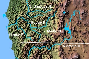
The Rogue Valley AVA is an American Viticultural Area located in southern Oregon. The federal government approved this appellation in 1991. It is entirely contained within the larger Southern Oregon AVA and includes the drainage basin of the Rogue River and several tributaries, including the Illinois River, the Applegate River, and Bear Creek. Most wineries in the region are found in the valleys formed by one of these three tributaries, rather than along the Rogue River itself. The region is 70 miles (113 km) wide by 60 miles (97 km) long ; there are fewer than 20 wineries with only 1,100 acres (450 ha) planted. Each river valley has a unique terroir, and grows different varieties of grapes. Overall, however, this region is the warmest and driest of Oregon's wine-growing regions.
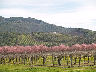
The Applegate Valley AVA is an American Viticultural Area located in southern Oregon. It is entirely contained within the Rogue Valley AVA, which is itself included within the larger Southern Oregon AVA. The region is named for the Applegate River, which flows through the town of Applegate and near the city of Jacksonville. The Applegate Valley has been a grape-growing region since 1870 when A. H. Carson began planting 30 acres of grapes along North Applegate Road. One of Oregon's first wineries was established in the Applegate Valley. This region contains vineyards at altitudes ranging from 1,000 feet (300 m) to 1,500 feet (500 m) above sea level, and is warmer and drier than the Illinois Valley to the west, but less so than the Bear Creek Valley to the east. Grapes that thrive here include Tempranillo, Merlot, Cabernet Franc, Cabernet Sauvignon, Syrah, Tannat, Vermentino, Chardonnay, and Zinfandel.
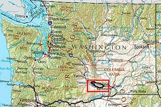
The Rattlesnake Hills AVA is an American Viticultural Area located in Yakima County, Washington. United States Alcohol and Tobacco Tax and Trade Bureau (TTB) awarded Rattlesnake Hills its appellation status on March 20, 2006, making Rattlesnake Hills Washington's ninth federally recognized American Viticultural Area. The Rattlesnake Hills AVA is entirely contained within the Yakima Valley AVA, which is in turn is entirely contained within the larger Columbia Valley AVA. The hills form the northern boundary of Yakima Valley, and the AVA includes land between the north bank of the Sunnyside Canal and the entirety of the southern slopes of the Rattlesnake Hills between Outlook and the Wapato Dam. The AVA is centered on the city of Zillah. With elevations ranging from 850 feet (259 m) to 3,085 feet (940 m), this AVA contains the highest point in the Yakima Valley AVA.

The Santa Maria Valley is an American Viticultural Area (AVA) which straddles the boundary of Santa Barbara and San Luis Obispo counties in California's multi-county Central Coast AVA. It was established on August 5, 1981, by the Alcohol and Tobacco Tax and Trade Bureau (TTB) as California's second oldest AVA. A portion of the AVA crosses the Cuyama River into the southernmost corner of San Luis Obispo County. The east–west orientation of the 152.3 square miles with a wide, open valley and rolling hills means cool winds and fog flow in freely from the Pacific Ocean, settling most noticeably in lower-lying areas. The result is a mild Mediterranean climate that lengthens the growing season and contributes to the eventual sugar/acid balance in the grapes from Santa Maria Valley's 7,500 acres (3,000 ha) cultivated vineyards. On January 28, 2011, the AVA was granted an 29.4 square miles expansion to its southern boundary.

The Augusta AVA was established on June 20, 1980 as the first federally approved American Viticultural Area, eight months before the Napa Valley AVA in northern California. The petition was submitted by Clayton W. Byers and Lucian W. Dressel, representing the local wine industry, to the Director of the Bureau of Alcohol, Tobacco and Firearms on October 16, 1978. Located entirely within the state of Missouri, the boundaries of this wine region encompass 15 square miles (39 km2) around the city of Augusta near the intersection of St. Charles County, Warren County and Franklin County.

The Snake River Valley AVA is an American Viticultural Area that encompasses an area in Southwestern Idaho and two counties in eastern Oregon. The Idaho Grape Growers and Wine Producers Commission and the Idaho Department of Commerce and Labor filed the petition to recognize the AVA, and it was granted in 2007.
The Ohio River Valley AVA is an American Viticultural Area centered on the Ohio River and surrounding areas. It is the second largest wine appellation of origin in the United States with 16,640,000 acres (26,000 sq mi) (67,300 km2) in portions of the states of Indiana, Kentucky, Ohio and West Virginia. The area is mostly planted with hybrid grapes like Baco noir, Marechal Foch, Seyval blanc and Vidal. Of the Vitis vinifera found in the area Cabernet Franc, Cabernet Sauvignon, Chardonnay, Petit Manseng and Riesling are the most common. The AVA size was decreased by approximately 1,530 square miles when the Indiana Uplands AVA was established in 2013 composed of the bordering area in Indiana.
The Dry Creek Valley AVA is an American Viticultural Area in Sonoma County, California, located northwest of the town of Healdsburg. The valley is formed by Dry Creek, a tributary of the Russian River, and is approximately 16 miles (25.7 km) long and 2 miles (3.2 km) wide. The appellation benefits from the proximity of the Lake Sonoma reservoir for irrigation in this relatively dry area.

The Howell Mountain AVA is an American Viticultural Area located within Napa Valley AVA of California.

The Texas High Plains AVA is an American Viticultural Area located on the Llano Estacado region of Texas. The appellation is the second largest American Viticultural Area in Texas, and covers an area of over 270,000 acres (422 sq mi). Most of the vineyards are on flat terrain at elevations between 3,000 feet (914 m) and 4,000 feet (1,219 m) above sea level. The Texas plains can be extremely dry, so most vineyards are irrigated with water from the Ogallala Aquifer. The hardiness zones are 7a and 7b.
The Ben Lomond Mountain AVA is an American Viticultural Area in Santa Cruz County, California, located on the western edge of the Santa Cruz Mountains. Jim Beauregard established the AVA in 1983 and Beauregard Vineyards continues to be only winery that currently produces wine bearing the Ben Lomond Mountain AVA designation. Vineyards were first planted on the mountain in the 1860s sitting at a premium spot for grape growing. The appellation ranges in altitudes as high as 2,600 feet (792 m) above sea level to 1300 feet, placing it between the fog that rolls in from the Pacific Ocean, ensuring long hours of sunlight and long growing season
Lake County wine is an appellation that designates wine made from grapes grown mostly in Lake County, California and located north of Napa County. Although each region within Lake County has unique viticultural attributes, all are influenced by Clear Lake, the largest inland body of water in California. Lake County enjoys a reputation for bright, concentrated red wines made from Cabernet Sauvignon, Syrah and Zinfandel, and fresh, aromatic whites made from Sauvignon Blanc. Cabernet Sauvignon has the most acreage, with Merlot a distant second.

The Grand Valley AVA is an American Viticultural Area located in Mesa County, Colorado, primarily in Grand Junction and Palisade. It is located roughly 200 miles (320 km) southwest of Denver. The high-desert AVA - with an average elevation of between 4,000 and 5,000 feet above sea level - is defined by the irrigated agricultural area served via canals within the Grand Valley of the Colorado River. The AVA was established in 1991 as the first of two Colorado wine regions. The West Elks AVA is the second federally designated AVA in Colorado.
The Warren Hills AVA is an American Viticultural Area located in Warren County, New Jersey. The Warren Hills region includes several small valleys formed by tributaries of the Delaware River. The valleys drain from northeast to southwest, and most vineyards in the area are planted on southeast-facing hill slopes. The region is primarily planted with French hybrid grapes. It has a humid continental climate (Dfa/Dfb) and is located in hardiness zones 6b and 6a.
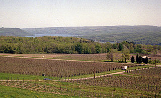
The Cayuga Lake AVA is an American Viticultural Area around Cayuga Lake in Upstate New York. The boundaries of the AVA include portions of Cayuga, Seneca, and Tompkins counties. Most of the vineyards in the AVA are planted in the shale soils of the hillsides on the western side of Cayuga Lake. Vineyards are planted at a range of elevations above the surface of the lake, up to 800 feet (244 m) higher. The steep hillsides and the lake together form a unique micro-climate in autumn that helps extend the growing season by preventing cold air from settling and producing frost. The Cayuga grape variety was created in this region by researchers at Cornell University.
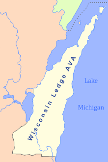
The Wisconsin Ledge AVA is an American Viticultural Area in northeast Wisconsin along the Niagara Escarpment in Door, Kewaunee, Manitowoc, Sheboygan, Ozaukee, Washington, Dodge, Fond du Lac, Calumet, Outagamie, and Brown counties. Certified by the United States Department of the Treasury's Alcohol and Tobacco Tax and Trade Bureau on March 22, 2012, it covers an area of 3,800 sq mi (9,800 km2) and is the second AVA designation wholly in Wisconsin, following the Lake Wisconsin AVA established in 1994. The state's third is the gargantuan Upper Mississippi River Valley AVA which also covers land in Minnesota, Iowa and Illinois. After 7 long years, and 4000 hours, Steven J. DeBaker of Trout Springs Winery was granted his petition to the TTB for establishment of the Wisconsin Ledge AVA. It became the 203rd AVA in the US, including just under 2.5 million acres making it the 12th largest AVA in the US. Today, there are 24 bonded wineries that lie within the AVA with over 400 acres of vines planted.
