
At 824,292 km2 (318,261 sq mi), Namibia is the world's thirty-fourth largest country. After Mongolia, Namibia is the second least densely populated country in the world. Namibia got its name from the Namib desert that stretches along the coast of the Atlantic. It is also known for its wildlife.

Walvis Bay is a city in Namibia and the name of the bay on which it lies. It is the second largest city in Namibia and the largest coastal city in the country. The city covers a total area of 29 square kilometres (11 sq mi) of land. The bay is a safe haven for sea vessels because of its natural deep-water harbour, protected by the Pelican Point sand spit, being the only natural harbour of any size along the country's coast. Being rich in plankton and marine life, these waters also drew large numbers of southern right whales, attracting whalers and fishing vessels.

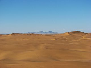
The Namib is a coastal desert in Southern Africa. According to the broadest definition, the Namib stretches for more than 2,000 kilometres (1,200 mi) along the Atlantic coasts of Angola, Namibia, and South Africa, extending southward from the Carunjamba River in Angola, through Namibia and to the Olifants River in Western Cape, South Africa. The Namib's northernmost portion, which extends 450 kilometres (280 mi) from the Angola-Namibia border, is known as Moçâmedes Desert, while its southern portion approaches the neighboring Kalahari Desert. From the Atlantic coast eastward, the Namib gradually ascends in elevation, reaching up to 200 kilometres (120 mi) inland to the foot of the Great Escarpment. Annual precipitation ranges from 2 millimetres (0.079 in) in the aridest regions to 200 millimetres (7.9 in) at the escarpment, making the Namib the only true desert in southern Africa. Having endured arid or semi-arid conditions for roughly 55–80 million years, the Namib may be the oldest desert in the world and contains some of the world's driest regions, with only western South America's Atacama Desert to challenge it for age and aridity benchmarks.

The Namib-Naukluft Park is a national park in western Namibia, situated between the coast of the Atlantic Ocean and the edge of the Great Escarpment. It encompasses part of the Namib Desert, the Naukluft mountain range, and the lagoon at Sandwich Harbour. The best-known area of the park and one of the main visitor attractions in Namibia is Sossusvlei, a clay pan surrounded by dunes, and Sesriem, a small canyon of the Tsauchab. The desert research station of Gobabeb is situated within the park.
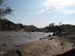
The Kuiseb River is an ephemeral river in western-central Namibia. Its source is in the Khomas Highland west of Windhoek. From there it flows westwards through the Namib-Naukluft National Park and the Namib desert to Walvis Bay. Several settlements of the Topnaar people are on the banks of the lower Kuiseb, for instance Homeb, Sandfontein, Rooibank, and Utuseb. Inflows of the Kuiseb are Gomab, Ojab, Chausib, Gaub, Koam, Nausgomab and Goagos.

Erongo is one of the 14 regions of Namibia. The capital is Swakopmund. It is named after Mount Erongo, a well-known landmark in Namibia and in this area. Erongo contains the municipalities of Walvis Bay, Swakopmund, Henties Bay and Omaruru, as well as the towns Arandis, Karibib and Usakos. All the main centres within this region are connected by paved roads.

The Skeleton Coast is the northern part of the Atlantic coast of Namibia. Immediately south of Angola, it stretches from the Kunene River to the Swakop River, although the name is sometimes used to describe the entire Namib Desert coast. The indigenous San people, of the Namibian interior called the region "The Land God Made in Anger", while Portuguese sailors once referred to it as "The Gates of Hell".

Sandboarding is a boardsport and extreme sport similar to snowboarding that involves riding across or down a sand dune while standing on a board, either with both feet strapped in or while standing loose, without bindings. Sandboarding can also be practised sitting down or lying on the belly or the back. It typically involves a sandboard, although it is also possible to use sleds, surfboards, a skateboard deck, or snowboards.

Swakopmund is a city on the coast of western Namibia, 352 km (219 mi) west of the Namibian capital Windhoek via the B2 main road. It is the capital of the Erongo administrative district. As of 2011, the town has 44,725 inhabitants and covers 196 km2 (76 sq mi) of land.

TransNamib Holdings Limited, commonly referred to as TransNamib, is a state-owned railway company in Namibia. Organised as a holding company, it provides both rail and road freight services, as well as passenger rail services. Its headquarters are in the country’s capital Windhoek.

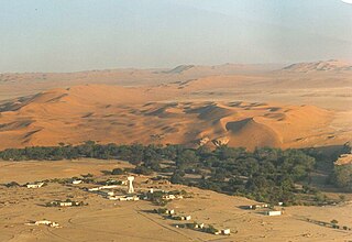
Solitaire is a small settlement in the Khomas Region of central Namibia near the Namib-Naukluft National Park. It currently features the only gasoline station, bakery, cafe, and the only general dealer between the dunes at Sossusvlei and the coast at Walvis Bay, as well as to the capital Windhoek. Solitaire belongs to the Windhoek Rural electoral constituency.
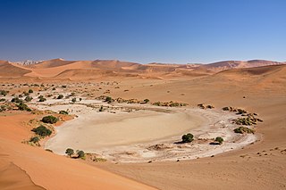
Sossusvlei is a salt and clay pan surrounded by high red dunes, located in the southern part of the Namib Desert, in the Namib-Naukluft National Park of Namibia. The name "Sossusvlei" is often used in an extended meaning to refer to the surrounding area. These landmarks are some of the major visitor attractions of Namibia.

Sandwich Harbour, also known as Sandwich Bay, Sandvishawe, Sandvisbaai and Sandfisch Bai is an area on the Atlantic coast of Namibia that includes a bay in the north and a lagoon at the southern end. Sandwich Harbour might have been named after an English whaling ship, the Sandwich, which worked during the 1780s, or the name may be a corruption of the German word "sandfische", a species of shark found in the area. Formerly the bay was a moderately-sized commercial port based around whaling and small-scale fishing, but it is now best known for its birdlife in the lagoon to the south of the bay.

Tourism in Namibia is a major industry, contributing N$7.2 billion to the country's gross domestic product. Annually, over one million travelers visit Namibia, with roughly one in three coming from South Africa, then Germany and finally the United Kingdom, Italy and France. The country is among the prime destinations in Africa and is known for ecotourism which features Namibia's extensive wildlife.
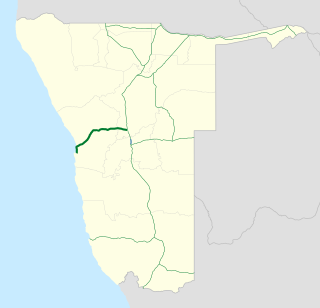
B2 is a major road in Namibia. The highway runs east–west between the major sea port of Walvis Bay and the nation's capital Windhoek.

Walvis Bay railway station is a railway station serving the port city of Walvis Bay in Namibia. It is part of the TransNamib railway network.
Dolfynstrand is a seaside resort on the South Atlantic coast of Namibia. The residential compound is located in the Walvis Bay constituency and just north of Langstrand, another beach resort located about 20 km south of Walvis Bay on the B2 Road towards Swakopmund. It is a popular destination for sport fishing in Namibia.

Rail service in Namibia is provided by TransNamib. The Namibian rail network consists of 2,687 route-km of tracks (2017).
Dorob National Park is a protected area in Erongo, along the central Namibian coast, which is 1,600 kilometres (990 mi) in length. It was gazetted as a national park under the Nature Conservation Ordinance No.4 of 1975 on 1 December 2010, and with Namib-Naukluft Park covers an area of 107,540 square kilometres (41,520 sq mi).


