
PAVE PAWS is a complex Cold War early warning radar and computer system developed in 1980 to "detect and characterize a sea-launched ballistic missile attack against the United States". The first solid-state phased array deployed used a pair of Raytheon AN/FPS-115 phased array radar sets at each site to cover an azimuth angle of 240 degrees. Two sites were deployed in 1980 at the periphery of the contiguous United States, then two more in 1987–95 as part of the United States Space Surveillance Network. One system was sold to Taiwan and is still in service.

The RCA 474L Ballistic Missile Early Warning System was a United States Air Force Cold War early warning radar, computer, and communications system, for ballistic missile detection. The network of twelve radars, which was constructed beginning in 1958 and became operational in 1961, was built to detect a "mass ballistic missile attack launched on northern approaches [for] 15 to 25 minutes' warning time" also provided Project Space Track satellite data.

The United States Space Surveillance Network (SSN) detects, tracks, catalogs and identifies artificial objects orbiting Earth, e.g. active/inactive satellites, spent rocket bodies, or fragmentation debris. The system is the responsibility of United States Space Command and operated by the United States Space Force.
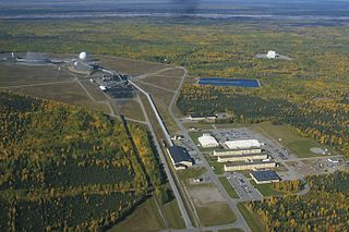
Clear Space Force Station is a United States Space Force radar station for detecting incoming ICBMs and submarine-launched ballistic missiles to NORAD's command center and to provide Space Surveillance data to the United States Space Force. Clear's AN/FPS-123 Upgraded Early Warning Radar is part of the Solid State Phased Array Radar System (SSPARS) which also includes those at Beale AFB, Cape Cod Space Force Station, RAF Fylingdales and Thule Site J. The "historic property" was one of the Alaska World War II Army Airfields and later a Cold War BMEWS site providing NORAD data to Colorado's BMEWS Central Computer and Display Facility (CC&DF).

Fort Fisher Air Force Station was a United States Air Force installation located on the Atlantic coast 0.8 miles (1.3 km) southwest of Kure Beach, North Carolina. Its primary mission was as a radar complex. It was closed on 30 June 1988 by the Air Force, and turned over to the Federal Aviation Administration (FAA).
Mount Hebo Air Force Station is a closed United States Air Force General Surveillance Radar station. It is located 5.2 miles (8.4 km) east-southeast of Hebo, Oregon, located at the top of 3,154-foot (961 m) Mount Hebo. It was closed in 1980.
Ground Equipment Facility J-33 is a Federal Aviation Administration (FAA) radar station of the Joint Surveillance System's Western Air Defense Sector (WADS) with an Air Route Surveillance Radar (ARSR-4). The facility was previously a USAF general surveillance radar station during the Cold War.

The AN/FPS-17 was a ground-based fixed-beam radar system that was installed at three locations worldwide, including Pirinçlik Air Base in south-eastern Turkey, Laredo, Texas and Shemya Island, Alaska.
Thomasville Air Force Station is a closed United States Air Force General Surveillance Radar station. It is located 1.9 miles (3.1 km) north-northwest of Thomasville, Alabama. It was closed in 1969.
Claysburg Air Force Station is a closed United States Air Force General Surveillance Radar station. It is located 6 miles (9.7 km) west of Claysburg, Pennsylvania. It was closed in 1961 due to budget constraints. The unit was eventually moved to Gibbsboro Air Force Station (RP-63), New Jersey.

Ground Equipment Facility QRC is an FAA radar station that was part of a Cold War SAGE radar station for aircraft control and warning "from Massachusetts to southern Virginia, and as far out to sea as possible." Benton AFS was also the first operational "regional data processing center" for the GE 477L Nuclear Detection and Reporting System.
The Avco AN/FPS-26 Radar was an Air Defense Command height finder radar developed in the Frequency Diversity Program with a tunable 3-cavity power klystron for electronic counter-countermeasures (e.g. to counter jamming). Accepted by the Rome Air Development Center on 20 January 1960 for use at SAGE radar stations, the AN/FPS-26 processed height-finder requests (e.g., from Air Defense Direction Centers) by positioning to the azimuth of a target aircraft using a high-pressure hydraulic drive, then "nodding" in either a default automatic mode or by operator command. The inflatable radome required a minimum pressure to prevent contact with the antenna which would result in damage to both (technicians accessed the antenna deck via an air lock.) To maintain high dielectric strength, the waveguide was pressurized with sulfur hexafluoride (SF6), which technicians were warned would produce deadly fluorine if waveguide arcing occurred.

Joelton Air Force Station is a closed United States Air Force General Surveillance Radar station. It is located 8.3 miles (13.4 km) west of Goodlettsville, Tennessee. It was closed in 1960.

Baudette Air Force Station is a closed United States Air Force General Surveillance Radar station. It is located 3.1 miles (5.0 km) south-southwest of Baudette, Minnesota. It was closed in 1979.

Havre Air Force Station is a Formerly Used Defense Site that was used as a Cold War general surveillance radar station. In addition to radar facilities and a NORAD Control Center the site had support services: NCO club, bowling alley, hobby shops, library, movie theater, barber shop, exchange, commissary, grade school, and housing for officers and senior NCOs.

Mount Laguna Air Force Station is a closed United States Air Force General Surveillance Radar station. It is located 24.3 miles (39.1 km) north-northeast of Tecate, California. It was closed in 1981 by the Air Force, and turned over to the Federal Aviation Administration (FAA).

The 14th Test Squadron is a United States Air Force unit located at Schriever Air Force Base, Colorado. It is an Air Force Reserve unit that augments the 17th Test Squadron. The squadron is responsible for testing and evaluating space systems and associated support equipment. The unit was originally established in 1972 as the 14th Missile Warning Squadron. The missile warning squadron was an active duty unit that operated early warning radars at eight locations around the United States until it was inactivated in 1980. The squadron was reactivated and given its current space test mission in 2000.
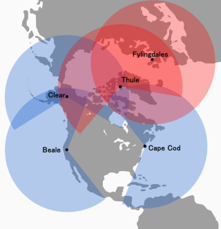
The Solid State Phased Array Radar System is a United States Space Force radar, computer, and communications system for missile warning and space surveillance "at five (5) geographically separated units worldwide including Beale Air Force Base, CA, Cape Cod Space Force Station, MA, Clear Space Force Station, AK, RAF Fylingdales, UK, and Pituffik Space Base, Greenland." SSPARS completed replacement of the RCA 474L Ballistic Missile Early Warning System when the last SSPAR was operational at Clear in 2001, the year SSPARS equipment included:

Thule Site J (J-Site) is a United States Space Force (USSF) radar station in Greenland near Pituffik Space Base for missile warning and spacecraft tracking. The northernmost station of the Solid State Phased Array Radar System, the military installation was built as the 1st site of the RCA 474L Ballistic Missile Early Warning System and had 5 of 12 BMEWS radars. The station has the following structures:

Eglin AFB Site C-6 is a United States Space Force radar station which houses the AN/FPS-85 phased array radar, associated computer processing system(s), and radar control equipment. Commencing operations in 1969, the AN/FPS-85 was the first large phased array radar. The entire radar/computer system is located at a receiver/transmitter building and is supported by the site's power plant, fire station, 2 water wells, and other infrastructure for the system. As part of the US Space Force's Space Surveillance Network its mission is to detect and track spacecraft and other manmade objects in Earth orbit for the Combined Space Operations Center satellite catalogue. With a peak radiated power of 32 megawatts the Space Force claims it is the most powerful radar in the world, and can track a basketball-sized object up to 22,000 nautical miles (41,000 km) from Earth.