Larger urban zone

Last updated

The larger urban zone (LUZ), or functional urban area (FUA), is a measure of the population and expanse of metropolitan and surrounding areas which may or may not be exclusively urban. [1] It consists of a city and its commuting zone outside it. [2]

Contents

The definition was introduced in 2004 by Eurostat, the statistical agency of the European Union (EU), in agreement with the national statistics offices in the member states. [3] [4] Eurostat data is provided only for zones in the EU countries, candidate countries and EFTA countries. Several cities were excluded by definition from the 2004 list of LUZs on technical, definitional grounds, such as the coincidence of the metropolitan area with the urban zone. [5] [6] [7]

The LUZ represents an attempt at a harmonised definition of the metropolitan area. Eurostat's objective was to have an area from which a significant share of the residents commute into the city, a concept known as the "functional urban region." To ensure a good data availability, Eurostat adjusts the LUZ boundaries to administrative boundaries that approximate the functional urban region.

In 2006 LUZ definitions were changed significantly, improving the comparability of LUZ definitions across different countries, and allowing for almost all cities to be included.

List of larger urban zones by population as of 2017

This is a list of larger urban zones by population as of 2017. The 2004 Urban Audit also includes cities from EFTA countries (Iceland, Liechtenstein, Norway and Switzerland) and EU candidate countries, although the only candidate country for which there is available data is Turkey. Some cities, including Marseille, Lille, Nice, Cordoba, Badajoz, Toulon and Montpellier were excluded from the 2004 list on technical, definitional grounds, such as the coincidence of the metropolitan area with the urban zone.

  Areas outside of the European Union
RankLarger urban zoneCountryPopulationArea (km2)
1 Paris Flag of France.svg  France 13,998,00012,079.87 [8]
2 Istanbul Flag of Turkey.svg  Turkey 11,154,928
3 London Flag of the United Kingdom.svg  United Kingdom 10,345,1248,900 [8]
4 Madrid Flag of Spain.svg  Spain 5,804,8298,022
5 Ruhr Area Flag of Germany.svg  Germany 5,302,1794,435
6 Berlin Flag of Germany.svg  Germany 4,971,33117,385
7 Naples Flag of Italy.svg  Italy 4,475,682564.95
8 Barcelona Flag of Spain.svg  Spain 4,233,6381,796.64
9 Athens Flag of Greece.svg  Greece 4,013,3683,806.92
10 Ankara Flag of Turkey.svg  Turkey 3,736,359
11 Rome Flag of Italy.svg  Italy 3,457,6903,666.66
12 Hamburg Flag of Germany.svg  Germany 3,134,6207,304
12 Milan Flag of Italy.svg  Italy 3,076,6431,348.32
13 Katowice metropolitan area Flag of Poland.svg  Poland 2,710,3972,650.65
14 Stuttgart Flag of Germany.svg  Germany 2,663,6603,654
15 Warsaw Flag of Poland.svg  Poland 2,631,7105,201.72
16 Manchester Flag of the United Kingdom.svg  United Kingdom 2,539,1001,280
17 Munich Flag of Germany.svg  Germany 2,531,7065,504
18 Frankfurt Flag of Germany.svg  Germany 2,517,5614,305
19 İzmir Flag of Turkey.svg  Turkey 2,459,474
20 Lisbon Flag of Portugal.svg  Portugal 2,435,8371,432.49
21 Budapest Flag of Hungary.svg  Hungary 2,393,8462,538 [8]
22 Leeds Flag of the United Kingdom.svg  United Kingdom 2,393,3005,114 [8]
23 Birmingham Flag of the United Kingdom.svg  United Kingdom 2,357,1001,598
24 Vienna Flag of Austria.svg  Austria 2,179,7694,610.93 [8]
25 Bucharest Flag of Romania.svg  Romania 2,140,194662
26 Prague Flag of the Czech Republic.svg  Czech Republic 1,964,7506,977 [8]
27 Cologne Flag of Germany.svg  Germany 1,873,5801,626
28 Stockholm Flag of Sweden.svg  Sweden 1,860,8726,519
29 Copenhagen Flag of Denmark.svg  Denmark 1,806,667 [8] 2,759 [8]
30 Brussels Flag of Belgium (civil).svg  Belgium 1,800,6631,613.91
31 Glasgow Flag of the United Kingdom.svg  United Kingdom 1,747,1003,346
32 Turin Flag of Italy.svg  Italy 1,745,2211,878.97
33 Lyon Flag of France.svg  France 1,717,3005,997.68 [8]
34 Belgrade Flag of Serbia.svg  Serbia 1,683,962514
35 Valencia Flag of Spain.svg  Spain 1,564,1451,440.58
36 Dublin Flag of Ireland.svg  Republic of Ireland 1,535,446 [8]
37 Düsseldorf Flag of Germany.svg  Germany 1,525,0291,201
38 Bursa Flag of Turkey.svg  Turkey 1,474,482
39 Amsterdam Flag of the Netherlands.svg  Netherlands 1,443,258859.28
40 Adana Flag of Turkey.svg  Turkey 1,394,130
41 Liverpool Flag of the United Kingdom.svg  United Kingdom 1,365,900821
42 Bielefeld Flag of Germany.svg  Germany 1,297,8762,921
43 Hanover Flag of Germany.svg  Germany 1,294,4472,966
44 Nuremberg Flag of Germany.svg  Germany 1,288,7972,934
45 Sheffield Flag of the United Kingdom.svg  United Kingdom 1,277,1001,846
46 Kraków Flag of Poland.svg  Poland 1,264,3222,988.65
47 Sofia Flag of Bulgaria.svg  Bulgaria 1,263,807 [8] 3,424.2 [8]
48 Seville Flag of Spain.svg  Spain 1,249,3463,081.9
49 Bremen Flag of Germany.svg  Germany 1,249,2915,885
50 Helsinki Flag of Finland.svg  Finland 1,224,1072,969.94
51 Rotterdam Flag of the Netherlands.svg  Netherlands 1,186,818611.75
52 Łódź Flag of Poland.svg  Poland 1,163,5162,857.51
53 Ostrava Flag of the Czech Republic.svg  Czech Republic 1,153,8763,889.6 [8]
54 Zürich Flag of Switzerland (Pantone).svg   Switzerland 1,110,4781,086.14
55 Tricity Flag of Poland.svg  Poland 1,105,2033,457.32
56 Porto Flag of Portugal.svg  Portugal 1,099,040562.32
57 Oslo Flag of Norway.svg  Norway 1,090,5136,920
58 Newcastle upon Tyne Flag of the United Kingdom.svg  United Kingdom 1,055,6003,385
59 Gaziantep Flag of Turkey.svg  Turkey 1,052,795
60 Toulouse Flag of France.svg  France 1,052,4974,706.93 [8]
61 Wrocław Flag of Poland.svg  Poland 1,031,4394,582.2
62 Poznań Flag of Poland.svg  Poland 1,018,5113,719.2
63 Gothenburg Flag of Sweden.svg  Sweden 1,015,9743,694.86
64 Bristol Flag of the United Kingdom.svg  United Kingdom 1,006,6001,635
65 Riga Flag of Latvia.svg  Latvia 1,003,9495,382.5

List of larger urban zones

This is a list of larger urban zones. The Urban Audit also includes cities from EFTA countries (Iceland, Liechtenstein, Norway and Switzerland) and EU candidate countries. The Organisation for Economic Co-operation and Development (OECD) uses a similar definition of Functional Urban Area to represent population sizes of cities in OECD countries. [9] This data is also included.

The figures in the Eurostat database are an attempt at a compromise between harmonised data for all of the European Union, and with availability of statistical data, making comparisons more accurate. [10]

  Areas outside of the European Union
Larger urban zoneCountryOECD Population (2014) [9] Eurostat Population (2006) [11] Eurostat Population (2016) [12]
Amsterdam metropolitan area Flag of the Netherlands.svg  Netherlands 2,452,6592,497,000 [lower-alpha 1] 2,771,661
Antwerp Flag of Belgium (civil).svg  Belgium 1,081,9041,406,000 [lower-alpha 2] 1,100,139
Athens Flag of Greece.svg  Greece 3,535,0553,761,0003,863,763
Barcelona metropolitan area Flag of Spain.svg  Spain 3,846,6974,082,000 [lower-alpha 3] 5,445,616
Berlin Flag of Germany.svg  Germany 4,399,5424,016,0005,005,216
Bilbao Flag of Spain.svg  Spain 1,013,805947,0001,025,109
Birmingham (West Midlands)Flag of the United Kingdom.svg  United Kingdom 1,957,0783,701,1072,332,629
Bordeaux Flag of France.svg  France 1,175,6991,244,264
Bremen Flag of Germany.svg  Germany 1,027,1921,077,0001,244,363
Bristol Flag of the United Kingdom.svg  United Kingdom 836,6211,041,0001,090,080
Brussels-Capital Region Flag of Belgium (civil).svg  Belgium 2,588,1022,639,000 [lower-alpha 2] 2,625,525
Bucharest metropolitan area Flag of Romania.svg  Romania 2,158,5582,403,107
Budapest metropolitan area Flag of Hungary.svg  Hungary 2,879,6012,523,0002,993,948
Cardiff Flag of the United Kingdom.svg  United Kingdom 664,8611,097,0001,085,526
Copenhagen Flag of Denmark.svg  Denmark 2,025,1711,881,000 [lower-alpha 4] 1,893,010
Dublin Metropolitan Area Flag of Ireland.svg  Ireland 1,836,1191,261,3321,263,035
Frankfurt/Rhine-Main Region Flag of Germany.svg  Germany 2,533,3112,764,000 [lower-alpha 5] 2,573,745
Gdańsk Flag of Poland.svg  Poland 1,105,4671,141,954 [lower-alpha 6]
Greater Glasgow Flag of the United Kingdom.svg  United Kingdom 967,1011,395,0001,789,003
Metropolitan Gothenburg Flag of Sweden.svg  Sweden 1,015,9741,006,548 [lower-alpha 7]
The Hague Flag of the Netherlands.svg  Netherlands 906,8971,404,000 [lower-alpha 1] 1,070,027
Hamburg Metropolitan Region Flag of Germany.svg  Germany 3,008,8412,983,0003,173,871
Hanover Flag of Germany.svg  Germany 1,217,5111,300,687
Helsinki Metropolitan Area Flag of Finland.svg  Finland 1,498,0501,285,0001,532,309
Katowice metropolitan area Flag of Poland.svg  Poland 2,589,3493,029,000 [lower-alpha 8] 2,743,929
Kraków metropolitan area Flag of Poland.svg  Poland 1,362,7401,236,0001,276,438
West Yorkshire (LeedsBradford)Flag of the United Kingdom.svg  United Kingdom 1,774,552 [lower-alpha 9] 2,302,0002,238,127
Lille–Kortrijk–Tournai Flag of France.svg  France /
Flag of Belgium (civil).svg  Belgium
1,363,465 [lower-alpha 10] 1,379,000 [lower-alpha 11] 2,572,374
Lisbon metropolitan area Flag of Portugal.svg  Portugal 3,039,6622,791,0002,839,908
Liverpool/Birkenhead Flag of the United Kingdom.svg  United Kingdom 954,1812,241,0001,352,000
Łódź Flag of Poland.svg  Poland 939,5681,165,0001,116,660
London metropolitan area Flag of the United Kingdom.svg  United Kingdom 11,701,23613,109,00012,250,000
Lyon Flag of France.svg  France 1,960,8471,669,0002,188,759
Madrid metropolitan area Flag of Spain.svg  Spain 7,079,1735,263,0006,378,297
Greater Manchester Flag of the United Kingdom.svg  United Kingdom 1,935,5592,556,0002,615,144
Mannheim Flag of Germany.svg  Germany 1,230,2761,172,821
Marseille Flag of France.svg  France 1,773,5031,530,0001,750,885 [lower-alpha 12]
Milan metropolitan area Flag of Italy.svg  Italy 4,159,8544,136,000 [lower-alpha 13] 4,267,946
Munich Flag of Germany.svg  Germany 2,965,8712,665,000 [lower-alpha 14] 2,808,581
Naples metropolitan area Flag of Italy.svg  Italy 4,475,6824,654,259 [lower-alpha 15] 4,127,390
Nice Flag of France.svg  France 865,1951,082,0001,017,307
Nottingham-Derby Flag of the United Kingdom.svg  United Kingdom 863,9181,614,0001,927,550
Nuremberg Metropolitan Region Flag of Germany.svg  Germany 1,169,3671,443,0001,301,504
Greater Oslo Flag of Norway.svg  Norway 1,299,9551,037,0001,144,883
Ostrava Flag of the Czech Republic.svg  Czech Republic no data no data1,119,593 [lower-alpha 16]
Paris metropolitan area Flag of France.svg  France 12,037,88913,975,00012,824,000
Porto Metropolitan Area Flag of Portugal.svg  Portugal 1,737,8291,245,000 [lower-alpha 17] 1,286,111
Portsmouth-Southampton Flag of the United Kingdom.svg  United Kingdom 594,4551,547,0001,498,402 [lower-alpha 18]
Prague Flag of the Czech Republic.svg  Czech Republic 1,910,3961,669,0002,224,080 [lower-alpha 19]
Rhein-Nord [lower-alpha 20] (DüsseldorfNeuss)Flag of Germany.svg  Germany 1,427,823 [lower-alpha 21] 3,073,000 [lower-alpha 22] 1,527,176
Rhein-Süd [lower-alpha 20] (Cologne – Bonn)Flag of Germany.svg  Germany 1,926,073 [lower-alpha 23] 3,070,000 [lower-alpha 22] 3,023,545 [lower-alpha 24]
Riga Flag of Latvia.svg  Latvia 1,195,0001,089,767
Rome metropolitan area Flag of Italy.svg  Italy 4,149,3644,353,7383,700,000
Rotterdam Flag of the Netherlands.svg  Netherlands 1,509,3731,904,000 [lower-alpha 1] 1,818,563
Ruhr area Flag of Germany.svg  Germany 5,376,000 [lower-alpha 22] 5,045,784
SaarbrückenForbach Flag of Germany.svg  Germany /
Flag of France.svg  France
570,479 [lower-alpha 26] 1,102,000822,128
Seville Flag of Spain.svg  Spain 1,500,6441,180,000 [lower-alpha 27] 1,877,060
Sofia Flag of Bulgaria.svg  Bulgaria 1,260,1201,543,377
Metropolitan Stockholm Flag of Sweden.svg  Sweden 2,018,2082,171,0002,034,354[ citation needed ]
South Yorkshire (Sheffield)Flag of the United Kingdom.svg  United Kingdom 920,1281,569,0001,596,298
Stuttgart Metropolitan Region Flag of Germany.svg  Germany 1,965,9422,289,0002,678,795
Thessaloniki metropolitan area Flag of Greece.svg  Greece 975,4391,052,0001,166,914
Toulouse Flag of France.svg  France 1,309,1491,388,978
Turin metropolitan area Flag of Italy.svg  Italy 1,774,5071,601,000 [lower-alpha 28] 2,302,353
Newcastle-Sunderland Flag of the United Kingdom.svg  United Kingdom 1,082,729 [lower-alpha 29] 1,599,0001,141,879
Valencia Flag of Spain.svg  Spain 1,668,1531,398,000 [lower-alpha 30] 2,516,818
Vienna Flag of Austria.svg  Austria 2,793,6312,584,0002,339,807
Warsaw metropolitan area Flag of Poland.svg  Poland 3,037,8902,785,0003,304,641
Zagreb Flag of Croatia.svg  Croatia 1,107,1151,123,374
Zürich metropolitan area Flag of Switzerland (Pantone).svg   Switzerland 1,246,9681,615,0001,984,534

See also

Notes

  1. 1 2 3 Part of the Randstad polycentric urban region consisting of the metropolitan areas of Amsterdam, Rotterdam, The Hague, and Utrecht (982,000). The total population of the region is 7,100,000.
  2. 1 2 The Flemish Diamond metropolitan region, which consists of the metropolitan areas of Brussels, Antwerp, Gent, and Leuven, has a total population of 5,103,000.
  3. Total population is 4,251,000 if the metropolitan area of Mataro (169,000) is included.
  4. Part of the wider Öresund region, which includes the Swedish metropolitan area of Malmö (961,000). The total regional population is 2,842,000.
  5. Part of the Rhein-Main metropolitan region with a total population of 4,149,000, which additionally includes the metropolitan areas of Darmstadt (501,000), Wiesbaden (453,000), and Mainz (431,000).
  6. 2014 data
  7. 2017 data
  8. Part of the polycentric Upper Silesian urban region with a total population of 5,294,000. The region additionally includes the metropolitan areas of Ostrava (1,046,000), Bielsko-Biala (584,000) and Rybnik (526,000).
  9. Leeds and Bradford counted separately.
  10. Kortrijk not included.
  11. Part of the wider Lille-Bassin Minier region with a total population of 3,115,000.
  12. 2014 data
  13. Part of a wider polycentric urban region with a population of 6,011,000.
  14. When combined with the Augsburg metropolitan area (606,000), the region has a total population of 3,271,000.
  15. Part of a wider polycentric urban region with a population of 3,714,000.
  16. 2015
  17. Part of a wider polycentric urban region with a population of 1,778,000.
  18. Excludes Southampton
  19. 2015
  20. 1 2 Polycentric metropolitan area
  21. Excludes Neuss.
  22. 1 2 3 Part of the polycentric urban region of Rhein-Ruhr, which has a total population of 12,190,000.
  23. Excludes Bonn which has a population of 750,370
  24. Excludes Bonn
  25. Essen, Bochum, and Dortmund counted separately.
  26. Saarbrücken only
  27. Total population is 1,262,000 if the metropolitan area of Utrera (82,000) is included.
  28. Total population is 1,716,000 if the metropolitan of Pinerolo is included.
  29. Excludes Sunderland
  30. Total population is 1,499,000 if the metropolitan area of Sagunto is included.

Related Research Articles

<span class="mw-page-title-main">Metropolitan area</span> Administrative unit of a dense urban core and its satellite cities

A metropolitan area or metro is a region consisting of a densely populated urban agglomeration and its surrounding territories sharing industries, commercial areas, transport network, infrastructures and housing. A metropolitan area usually comprises multiple principal cities, jurisdictions and municipalities: neighborhoods, townships, boroughs, cities, towns, exurbs, suburbs, counties, districts and even states and nations in areas like the eurodistricts. As social, economic and political institutions have changed, metropolitan areas have become key economic and political regions.

<span class="mw-page-title-main">Upper Silesian metropolitan area</span> Place in Mainly Silesia

The Upper Silesian metropolitan area is a metropolitan area in southern Poland and northeastern Czech Republic, centered on the cities of Katowice and Ostrava in Silesia and has around 5 million inhabitants. Located in the three administrative units : mainly Silesian Voivodeship, a small western part of Lesser Poland Voivodeship and a small east part of Moravian-Silesian Region.

<span class="mw-page-title-main">London metropolitan area</span> Region of England

The London metropolitan area is the metropolitan area of London, England. It has several definitions, including the London Travel to Work Area, and usually consists of the London urban area, settlements that share London's infrastructure, and places from which it is practicable to commute to work in London. It is also known as the London commuter belt, or Southeast metropolitan area.

<span class="mw-page-title-main">Nomenclature of Territorial Units for Statistics</span> European Union standard for country subdivisions

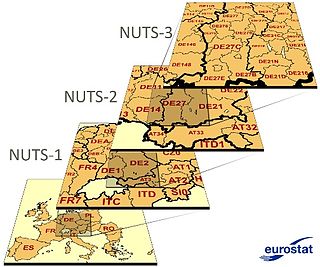
Nomenclature of Territorial Units for Statistics or NUTS is a geocode standard for referencing the administrative divisions of countries for statistical purposes. The standard, adopted in 2003, is developed and regulated by the European Union, and thus only covers the EU member states in detail. The Nomenclature of Territorial Units for Statistics is instrumental in the European Union's Structural Funds and Cohesion Fund delivery mechanisms and for locating the area where goods and services subject to European public procurement legislation are to be delivered.

<span class="mw-page-title-main">Eurostat</span> Statistics agency of the European Union

Eurostat is a Directorate-General of the European Commission located in the Kirchberg quarter of Luxembourg City, Luxembourg. Eurostat's main responsibilities are to provide statistical information to the institutions of the European Union (EU) and to promote the harmonisation of statistical methods across its member states and candidates for accession as well as EFTA countries. The organisations in the different countries that cooperate with Eurostat are summarised under the concept of the European Statistical System.

<span class="mw-page-title-main">Hamburg Metropolitan Region</span> Place in Germany

The Hamburg Metropolitan Region is a metropolitan area centred around the city of Hamburg in northern Germany, consisting of eight districts in the federal state of Lower Saxony, six districts in the state of Schleswig-Holstein and two districts in the state of Mecklenburg-Vorpommern along with the city-state of Hamburg itself. It covers an area of roughly 26,000 square kilometres (10,000 sq mi) and is home to more than 5.1 million inhabitants.

Statistics in the European Union are collected by Eurostat.

<span class="mw-page-title-main">Madrid metropolitan area</span> Comprises the city of Madrid and twenty surrounding municipalities

The Madrid metropolitan area is a monocentric metropolitan area in the centre of the Iberian peninsula, around the municipality of Madrid, Spain. It is not related to any sort of administrative delimitation, and thus, its limits are ambiguous.

<span class="mw-page-title-main">Oradea metropolitan area</span> Metropolitan area in Bihor, Romania

Oradea metropolitan area is a metropolitan area located in Western Romania, in the County of Bihor, Crișana, Transylvania, Romania and was founded on 9 May 2005.

<span class="mw-page-title-main">Katowice urban area</span> Silesian conurbation and largest urban area in Poland

The Katowice urban area, also known as the Upper Silesian urban area, is an urban area/conurbation in southern Poland, centered on Katowice. It is located in the Silesian Voivodeship and in a small part of the Lesser Poland Voivodeship. The Katowice urban area is the largest urban area in Poland and one of the largest in the European Union.

<span class="mw-page-title-main">Barcelona metropolitan area</span> Urban area in Catalonia, Spain

The Barcelona urban area is an urban area in Catalonia (Spain) centered on the city of Barcelona and located less than 100 km south of the border with France. With a population of over 5 million, it is one of the largest urban areas in Europe.

<span class="mw-page-title-main">Cologne Bonn Region</span> Metropolitan area in North Rhine-Westphalia, Germany

The Cologne Bonn Region is a metropolitan area in North Rhine-Westphalia (NRW), Germany, covering the cities of Cologne, Bonn and Leverkusen, as well as the districts of Rheinisch-Bergischer Kreis, Oberbergischer Kreis, Rhein-Erft-Kreis and Rhein-Sieg-Kreis. The region covers an area of 3,839 km² with 3.13 million inhabitants. The city centres of Cologne and Bonn are 24 kilometres apart as the crow flies. At the outer city limits, there are only 8 kilometres between Cologne-Libur and Bonn-Geislar.

<span class="mw-page-title-main">Frankfurt Rhine-Main</span> Place in Germany

The Rhine-Main Metropolitan Region, often simply referred to as Frankfurt Rhine-Main, Frankfurt Rhine-Main area or Rhine-Main area, is the second-largest metropolitan region in Germany after Rhine-Ruhr, with a total population exceeding 5.8 million. The metropolitan region is located in the central-western part of Germany, and stretches over parts of three German states: Hesse, Rhineland-Palatinate, and Bavaria. The largest cities in the region are Frankfurt am Main, Wiesbaden, Mainz, Darmstadt, Offenbach, Worms, Hanau, and Aschaffenburg.

<span class="mw-page-title-main">Core city</span> Largest or most important city of a metropolitan area

In urban planning, a historic core city or central city is the municipality with the largest 1940 population in the present metropolitan area. This term was retired by the US census bureau and replaced by the term principal city, which can include historic core cities and post-WWII cities. Metropolitan areas were no longer considered monocentric, but polycentric due to suburbanization of employment. A historic core city is not to be confused with the core of a metropolitan area which is defined as an urban area with a population of over 50,000 by the US census bureau.

<span class="mw-page-title-main">Munich Metropolitan Region</span> Metropolitan region in Germany

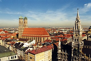
The Munich Metropolitan Region is one of eleven metropolitan regions in Germany, consisting of the agglomeration areas of Munich, Augsburg, Ingolstadt, Landshut, Rosenheim and Landsberg am Lech. It is Germany's fifth most populous metropolitan region after the Rhine-Ruhr Metropolitan-Region, the Frankfurt Rhine-Main-Region, the Berlin-Brandenburg Metropolitan-Region and the Stuttgart Metropolitan-Region.

<span class="mw-page-title-main">Functional area (France)</span> Statistical area in France

An aire d'attraction d'une ville is a statistical area used by France's national statistics office INSEE since 2020, officially translated as functional area in English by INSEE, which consists of a densely populated urban agglomeration and the surrounding exurbs, towns and intervening rural areas that are socioeconomically tied to the central urban agglomeration, as measured by commuting patterns. INSEE's functional area (AAV) is therefore akin to what is most often called metropolitan area in English.

<span class="mw-page-title-main">Vilnius urban area</span> Urban area in Lithuania

The Vilnius urban area is the urban area of Vilnius. The urban area covers several municipalities in the Vilnius County.

References

  1. Position Statement on Cohesion Policy 2014–2020 Archived 2 July 2015 at the Wayback Machine , EuroMETREX. Retrieved 2 July 2015.
  2. "European cities – the EU-OECD functional urban area definition". Eurostat.
  3. "City statistics – Urban audit". Eurostat. 2006. Archived from the original on 6 February 2009.
  4. "The shift of Eurostat to Urban Statistics". Dr. Berthold Feldmann, Eurostat. March 2006. Archived from the original on 20 September 2006.
  5. www.statistiques-locales.insee.fr(PDF) https://web.archive.org/web/20110727094822/http://www.statistiques-locales.insee.fr/Fiches/RS/AU1999/RS_AU1999003.pdf. Archived from the original (PDF) on 27 July 2011.{{cite web}}: Missing or empty |title= (help)
  6. (PDF) https://web.archive.org/web/20110727094843/http://www.statistiques-locales.insee.fr/Fiches/RS/AU1999/RS_AU1999004.pdf. Archived from the original (PDF) on 27 July 2011. Retrieved 19 February 2016.{{cite web}}: Missing or empty |title= (help)
  7. (PDF) https://web.archive.org/web/20110727094905/http://www.statistiques-locales.insee.fr/Fiches/RS/AU1999/RS_AU1999006.pdf. Archived from the original (PDF) on 27 July 2011. Retrieved 19 February 2016.{{cite web}}: Missing or empty |title= (help)
  8. 1 2 3 4 5 6 7 8 9 10 11 12 13 14 Data for 2001 (2004 data not yet available)
  9. 1 2 "OECD Populations in cities". OECD. Retrieved 2 April 2017.
  10. "Urban Audit Database". Urbanaudit.org. Archived from the original on 23 May 2011. Retrieved 29 April 2011.
  11. European Spatial Planning Observation Network, Study on Urban Functions (Project 1.4.3) Archived 24 September 2015 at the Wayback Machine , Final Report, Chapter 3, (ESPON, 2007)
  12. http://appsso.eurostat.ec.europa.eu/nui/show.do?dataset=urb_lpop1&lang=en [ bare URL ]