Lasley Vore Site

Last updated
Lasley Vore Site
Site notes
Discovered1988
ArchaeologistsDr. George H. Odell
Public accessNone

The Lasley Vore Site is an archaeological site near the Arkansas River in Tulsa County, Oklahoma. Based on an archeological study in 1988 conducted by the University of Tulsa, this is believed to be the remains of a Wichita village of about 6,000 people, as described by French explorer and trader Jean-Baptiste Bénard de la Harpe in his record of his 1719 trading expedition to this region. Although no evidence of historic structures was found, investigators did find hearths and pits, and have recovered various Wichita, French and European artifacts that have been dated to the early to mid eighteenth century. The project leader published his findings in a 2002 book.

Contents

Discovery

The Lasley Vore Site was discovered in 1988, during an environmental impact assessment for a proposed manufacturing site overlooking the Arkansas River, 13 miles (21 km) south of Tulsa, Oklahoma. [1] The study, which had been commissioned by the Kimberly Clark Corporation, was led by Dr. George H. Odell (1942 - 2011), an anthropology professor at the University of Tulsa. Field work was carried out during May and June, 1988. The tight schedule was dictated by Kimberly-Clark's schedule for constructing a paper products plant on the property. [2]

The site was named for an early landowner, Lasley Vore, a Muscogee man who had settled on it about 1890 and developed a farm. Vore died in 1898, and was buried in a small family cemetery that still existed near the site. [lower-alpha 1] The house and buildings were sold to J. F. Kay, Sr., who moved in with his wife and son, J. F. Kay Jr. The father continued to farm there until he died in 1955; his widow then moved to Bixby. The house burned down about 1970. The land was used for a dairy farm for a few years, then was bought by Fred Parkhill, owner of a Tulsa liquor store. He owned the property for about 15 years, then sold it to Kimberly-Clark. [4]

Because of the schedule constraints, Odell initially used a Ditch Witch trenching tool to define the extent of the study. Although the company owned a quarter section of land (160 acres), Odell determined by trenching that only an area of 2 - 3 hectares (4.9 - 7.5 acres) was of archaeological interest for study. He had the topsoil removed with a belly loader, to expose the subsoil. [lower-alpha 2] Stains and smears showed where storage pits, trash pits and hearths had been dug into the subsoil during historic times. Odell reported finding 81 such features. [2]

Artifacts

Many items found at the site included Native American artifacts characteristic of the early to mid 18th century, while others were of European origin during the same period. Radiocarbon dating was used to confirm the time of their origin. Odell suggested that the artifacts suggested that this was a semi-permanent Wichita village that had been visited by a European trading party. [1] Wichita artifacts found at the excavations included hide scrapers, projectile points, bison scapulae hoes, and pottery. French-style trade goods from the 18th century found here included trade beads, axe heads, metal knives, and gun parts. [2]

In his 2002 book, Odell explains that the gun parts were the only artifacts from the Lasley Vore site that could be positively identified as coming from a specific country (France) at a specific time (early 18th century). He said that la Harpe could have brought these parts in 1719. The other artifacts were consistent with La Harpe's description of the village and his mission. [5]

La Harpe Expedition

Based on expedition records, historians have long known that Jean-Baptiste Bénard de la Harpe, a French trader, explorer and nobleman, had led an expedition into what is now Oklahoma in 1718-19. His original objective was to establish a trading post at the site of what became the present city of Texarkana, Arkansas, but he extended his trip as far north as the Arkansas River (which he designated as the Alcansas). After returning to France, the explorer wrote that he and 9 other men, including three Caddo guides, led a train of 22 horses loaded with trade goods; they had come to a native settlement overlooking the river. The town had about 6,000 natives, mostly Tawakoni (a sub-group of the Wichita people), although some were Taovaya (another sub-group of the Wichita).

Harpe's party received a warm welcome, were honored with the calumet ceremony and spent ten days at this location. Meanwhile, about 1,000 more related people arrived at the settlement wanting to see these Europeans, trade, and participate in the festivities. [1] [6] [lower-alpha 3]

Notes

  1. A more exact location for the site is given by Odell as 131st Street and South Yale Avenue in Tulsa. [3]
  2. Machines like the trenching tool and the belly loader are more often associated with larger construction projects, while archaeological digs are often performed by hand. The compressed schedule did not allow time for extensive hand digging. Fortunately, a contractor was already using the same equipment to move dirt on another part of the Kimberly-Clark property and readily agreed to perform the work needed by Odell. The property had previously been farmed, so the topsoil had been repeatedly disturbed by plowing. [2]
  3. According to an article in the Encyclopedia of the Great Plains, the calumet ceremony was associated with several days of feasting, gift giving, singing and dancing. It climaxed with the presentation of the calumet (peace pipe), which represented unrelated people becoming one family, thus forming lasting trade bonds. [7]

Related Research Articles

<span class="mw-page-title-main">Tulsa County, Oklahoma</span> County in the United States

Tulsa County is located in the U.S. state of Oklahoma. As of the 2020 census, the population was 669,279, making it the second-most populous county in the state, behind only Oklahoma County. Its county seat and largest city is Tulsa, the second-largest city in the state. Founded at statehood, in 1907, it was named after the previously established city of Tulsa. Before statehood, the area was part of both the Creek Nation and the Cooweescoowee District of Cherokee Nation in Indian Territory.

<span class="mw-page-title-main">Muskogee County, Oklahoma</span> County in Oklahoma, United States

Muskogee County is a county located in the U.S. state of Oklahoma. As of the 2020 census, the population was 66,339. The county seat is Muskogee. The county and city were named for the Muscogee (Creek) Nation. The official spelling of the name was changed to Muskogee by the post office in 1900.

<span class="mw-page-title-main">Haileyville, Oklahoma</span> City in Oklahoma, United States

Haileyville is a city in Pittsburg County, Oklahoma, United States. The population was 813 at the 2010 census.

<span class="mw-page-title-main">Arkansas River</span> Major tributary of the Mississippi River, United States

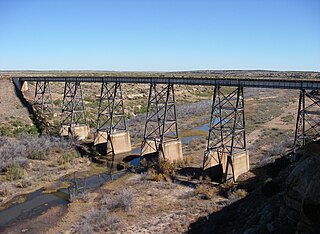
The Arkansas River is a major tributary of the Mississippi River. It generally flows to the east and southeast as it traverses the U.S. states of Colorado, Kansas, Oklahoma, and Arkansas. The river's source basin lies in Colorado, specifically the Arkansas River Valley. The headwaters derive from the snowpack in the Sawatch and Mosquito mountain ranges. It flows east into Kansas and finally through Oklahoma and Arkansas, where it meets the Mississippi River.

<span class="mw-page-title-main">Caddo</span> Southeastern Native American tribe

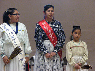
The Caddo people comprise the Caddo Nation of Oklahoma, a federally recognized tribe headquartered in Binger, Oklahoma. They speak the Caddo language.

<span class="mw-page-title-main">Canadian River</span> Major tributary of the Arkansas River

The Canadian River is the longest tributary of the Arkansas River in the United States. It is about 1,026 miles (1,651 km) long, starting in Colorado and traveling through New Mexico, the Texas Panhandle, and Oklahoma. The drainage area is about 47,700 square miles (124,000 km2).

<span class="mw-page-title-main">Mississippi Company</span> Monopoly in French colonies in North America and the West Indies

The Mississippi Company was a corporation holding a business monopoly in French colonies in North America and the West Indies. In 1717, the Mississippi Company received a royal grant with exclusive trading rights for 25 years. The rise and fall of the company is connected with the activities of the Scottish financier and economist John Law who was then the Controller General of Finances of France. Though the company itself started to become profitable and remained solvent until the collapse of the bubble, when speculation in French financial circles and land development in the region became frenzied and detached from economic reality, the Mississippi bubble became one of the earliest examples of an economic bubble.

<span class="mw-page-title-main">Wichita people</span> Confederation of Native Americans

The Wichita people, or Kitikiti'sh, are a confederation of Southern Plains Native American tribes. Historically they spoke the Wichita language and Kichai language, both Caddoan languages. They are indigenous to Oklahoma, Texas, and Kansas.

<span class="mw-page-title-main">Spiro Mounds</span> United States historic place

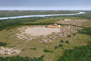
Spiro Mounds is an archaeological site located in present-day eastern Oklahoma that remains from an indigenous Indian culture that was part of the major northern Caddoan Mississippian culture. The 80-acre site is located within a floodplain on the southern side of the Arkansas River. The modern town of Spiro developed approximately seven miles to the south.

<span class="mw-page-title-main">Tawakoni</span> Indigenous tribe in the United States

The Tawakoni are a Southern Plains Native American tribe, closely related to the Wichitas. They historically spoke a Wichita language of the Caddoan language family. Currently, they are enrolled in the Wichita and Affiliated Tribes, a federally recognized tribe.

Jean-Baptiste Bénard de la Harpe was a French explorer who is credited with using the name "Little Rock" in 1722 for a stone outcropping on the bank of the Arkansas River used by early travelers as a landmark. Little Rock, Arkansas was subsequently named for the landmark.

Le Poste des Cadodaquious was a small French fort founded in 1719; it was located northwest of Texarkana, Texas in today's Bowie County. Recent analysis suggests that the site was somewhere on the escarpment near either Everett or Barkman.

Martín de Alarcón was the Governor of Coahuila and Spanish Texas from 1705 until 1708, and again from 1716 until 1719. He founded San Antonio, the first Spanish civilian settlement in Texas.

The Nanatsoho were a Native American tribe that lived at the border of Arkansas, Oklahoma, and Texas.

<span class="mw-page-title-main">Etzanoa</span> Historical city of the Wichita people in Kansas, United States

Etzanoa is a historical city of the Wichita people, located in present-day Arkansas City, Kansas, near the Arkansas River, that flourished between 1450 and 1700. Dubbed "the Great Settlement" by Spanish explorers who visited the site, Etzanoa may have housed 20,000 Wichita people. The historical city is considered part of Quivira.

The Taovaya tribe of the Wichita people were Native Americans originally from Kansas, who moved south into Oklahoma and Texas in the 18th century. They spoke the Taovaya dialect of the Wichita language, a Caddoan language. Taovaya people today are enrolled in the Wichita and Affiliated Tribes, a federally recognized tribe headquartered in Anadarko, Oklahoma.

<span class="mw-page-title-main">Waco people</span> North American indigenous tribe

The Waco of the Wichita people are a Southern Plains Native American tribe that inhabited northeastern Texas. Today, they are enrolled members of the federally recognized Wichita and Affiliated Tribes, headquartered in Anadarko, Oklahoma.

Three Forks Oklahoma is an imprecisely defined area of what is now eastern Oklahoma, around the confluence of the Arkansas, Verdigris, and Grand Rivers. The term, "Three Forks," was apparently used to designate this area as early as 1719, when the French trader Bernard de la Harpe traveled through the area, meeting and trading with members of the Wichita tribe at a place on the Arkansas River immediately south of the present city of Tulsa.

Richmond is an unincorporated community in Little River County, Arkansas, United States.

<span class="mw-page-title-main">Mildred Mott Wedel</span> American archaeologist and ethnologist

Mildred Mott Wedel was an American scholar of Great Plains archaeology and ethnohistory. She was one of the first professionally trained female archaeologists and was distinguished in her field. Many of her publications were about the Siouan people, and wrote several important articles on French exploration in the Central and Southern Plains.

References

Additional Resource

See also