Related Research Articles
Vicus Tuscus was an ancient street in the city of Rome, running southwest out of the Roman Forum between the Basilica Julia and the Temple of Castor and Pollux towards the Forum Boarium and Circus Maximus via the west side of the Palatine Hill and Velabrum.

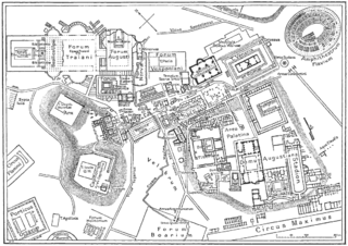
The Mamertine Prison, in antiquity the Tullianum, was a prison (carcer) with a dungeon (oubliette) located in the Comitium in ancient Rome. It is said to have been built in the 7th century BC and was situated on the northeastern slope of the Capitoline Hill, facing the Curia and the imperial fora of Nerva, Vespasian, and Augustus. Located between it and the Tabularium was a flight of stairs leading to the Arx of the Capitoline known as the Gemonian stairs.

The Circus Flaminius was a large, circular area in ancient Rome, located in the southern end of the Campus Martius near the Tiber River. It contained a small race-track used for obscure games, and various other buildings and monuments. It was "built", or sectioned off, by Gaius Flaminius in 221 BC. After Augustus divided the city into 14 administrative regions, the Circus Flaminius gave its name to Regio IX, which encompassed the Circus and all of the Campus Martius west of the Via Lata.

The Ficus Ruminalis was a wild fig tree that had religious and mythological significance in ancient Rome. It stood near the small cave known as the Lupercal at the foot of the Palatine Hill and was the spot where according to tradition the floating makeshift cradle of Romulus and Remus landed on the banks of the Tiber. There they were nurtured by the she-wolf and discovered by Faustulus. The tree was sacred to Rumina, one of the birth and childhood deities, who protected breastfeeding in humans and animals. St. Augustine mentions a Jupiter Ruminus.

The Suburra, or Subura, was a vast and populous neighborhood of Ancient Rome, located below the Murus Terreus on the Carinae and stretching on the slopes of the Quirinal and Viminal hills up to the offshoots of the Esquiline.
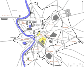
In 7 BC, Augustus divided the city of Rome into 14 administrative regions. These replaced the four regiones—or "quarters"—traditionally attributed to Servius Tullius, sixth king of Rome. They were further divided into official neighborhoods.

Carinae was an area of ancient Rome. It was one of its most exclusive neighborhoods, where many of the senatorial class lived.
Florus described the Carinae as the "most celebrated part of the city".

The main road to the Roman Capitol, the Clivus Capitolinus starts at the head of the Roman Forum beside the Arch of Tiberius as a continuation of the Via Sacra; proceeding around the Temple of Saturn and turning to the south in front of the Portico Dii Consentes, it then climbs up the slope of the Capitoline Hill to the Temple of Jupiter Optimus Maximus at its summit. This was traditionally the last and culminating portion of all Roman triumphs.

The topography of ancient Rome is the description of the built environment of the city of ancient Rome. It is a multidisciplinary field of study that draws on archaeology, epigraphy, cartography and philology. The word 'topography' here has its older sense of a description of a place, now often considered to be local history, rather than its usual modern meaning, the study of landforms.

The Arch of Dolabella and Silanus or Arch of Dolabella is an ancient Roman arch. It was built by senatorial decree in 10 AD by the consuls P. Cornelius Dolabella and C. Junius Silanus.

The Porta Fontinalis was a gate in the Servian Wall in ancient Rome. It was located on the northern slope of the Capitoline Hill, probably the northeast shoulder over the Clivus Argentarius. The Via Salaria exited through it, as did the Via Flaminia originally, providing a direct link with Picene and Gallic territory. After the Aurelian Walls were constructed toward the end of the 3rd century AD, the section of the Via Flaminia that ran between the Porta Fontinalis and the new Porta Flaminia was called the Via Lata ("Broadway").

Iana is the name of an ancient Roman goddess associated with arches and the moon, usually identified as either a form of Diana or the female counterpart of Janus.
The Porta Querquetulana or Querquetularia was a gateway in the Servian Wall, named after the sacred grove of the Querquetulanae adjacent to and just within it. The grove appears not to have still existed in the latter 1st century BC.
The Curia Calabra was a religious station or templum used for the ritual observation of the new moon in ancient Rome. Although its exact location is unclear, it was most likely a roofless enclosure in front of an augural hut (auguraculum), on the southwest flank of the Area Capitolina, the precinct of the Temple of Capitoline Jupiter. Servius identifies the Curia Calabra with a Casa Romuli on the Capitoline, but Macrobius implies that it was adjacent to the Casa.
The Porta Carmentalis was a double gate in the Servian Walls of ancient Rome. It was named for a nearby shrine to the goddess or nymph Carmenta, whose importance in early Roman religion is also indicated by the assignment of one of the fifteen flamines to her cult, and by the archaic festival in her honor, the Carmentalia. The shrine was to the right as one exited the gate.

The Clivus Scauri was an ancient Roman road that originally branched off from the road that connected the Circus Maximus to the Colosseum along the depression between the Palatine and Caelian hills of Rome. It followed the east side of the latter, up to its summit, which is today known as Piazza della Navicella. In the initial section the road has retained the old name. It becomes Via di S. Paolo della Croce further up the hill.

Vicus Patricius was a street in ancient Rome, whose route corresponds to that of the present Via Urbana.
It started from the point where the Argiletum branched into clivus Suburanus and vicus Patricius, crossed the Cispian and the Viminal hills and reached the Porta Viminalis in the Servian Wall.
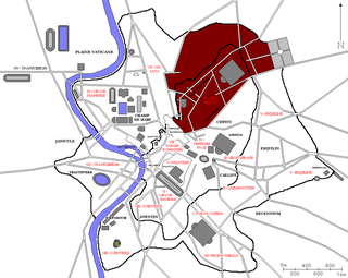
The Regio VI Alta Semita is the sixth regio of imperial Rome, under Augustus's administrative reform. Regio VI took its name from the street passing over the Quirinal Hill. It was a large regio that also encompassed the Viminal Hill, the lower slopes of the Pincian, and the valleys in-between.

The Regio VIII Forum Romanum Magnum is the eighth regio of imperial Rome, under Augustus's administrative reform. Regio VIII took its name from the Roman Forum, the political centre of Ancient Rome.
References
- ↑ Samuel Ball Platner, The Topography and Monuments of Ancient Rome (Allyn and Bacon, 1911, 2nd ed.), p. 169.
- ↑ Lawrence Richardson, A New Topographical Dictionary of Ancient Rome (Johns Hopkins University Press, 1992), p. 234.
- ↑ Richardson, Topographical Dictionary, p. 142.
- ↑ Platner, Topography and Monuments of Ancient Rome, pp. 171–172.
- ↑ Richardson, Topographical Dictionary, p. 88.
- ↑ Platner, Topography and Monuments of Ancient Rome, pp. 171–172.
- ↑ Livy 32.26.17; Seneca Rhetor Controversiae 9.4[27].21; Richardson, Topographical Dictionary, p. 234.
- ↑ Platner, Topography and Monuments of Ancient Rome, p. 252.
- ↑ Ann Thomas Wilkins, "Sallust's Tullianum: Reality, Description, and Beyond," in Rome and Her Monuments: Essays on the City and Literature of Rome in Honor of Katherine A. Geffcken (Bolchazy-Carducci, 2000), p. 123.
- ↑ Platner, Topography and Monuments of Ancient Rome, p. 252.
- ↑ Varro, De lingua latina 5.151; Paulus ex Festo 104 (edition of Lindsay); Richardson, Topographical Dictionary, p. 234.
- ↑ Varro, De lingua latina 5.151; Wilkins, "Sallust's Tullianum," p. 123.
- ↑ Richardson, Topographical Dictionary, p. 234.
- ↑ Livy 26.27.3, 27.11.16; Richardson, Topographical Dictionary, pp. 42, 169.
- ↑ Richardson, Topographical Dictionary, p. 41.
- ↑ Richardson, Topographical Dictionary, p. 88.
- ↑ Jean Andrea, Banking and Business in the Roman World (Cambridge University Press, 1999), p. xiii.