
The Ledo Road was an overland connection between British India and China, built during World War II to enable the Western Allies to deliver supplies to China and aid the war effort against Japan. After the Japanese cut off the Burma Road in 1942 an alternative was required, hence the construction of the Ledo Road. It was renamed the Stilwell Road, after General Joseph Stilwell of the U.S. Army, in early 1945 at the suggestion of Chiang Kai-shek. It passes through the Burmese towns of Shingbwiyang, Myitkyina and Bhamo in Kachin state. Of the 1,726 kilometres (1,072 mi) long road, 1,033 kilometres (642 mi) are in Burma and 632 kilometres (393 mi) in China with the remainder 61 km was in India. The road had the Ledo-Pangsau Pass-Tanai (Danai)-Myitkyina--Bhamo-Mansi-Namhkam-Kunming route.
The efficient running of the North-east Indian railways during World War II became critical to the success of the Allied war effort in the South-East Asian Theatre.

New Jalpaiguri Junction railway station established in 1960, is an A1 category broad-gauge and narrow-gauge railway station under Katihar railway division of Northeast Frontier Railway zone. It is the largest and the busiest railway junction of northeast India. This junction is largest among the railway stations which serve the city of Siliguri, the largest metropolis of the North Bengal. The other stations are- Siliguri Junction, Gulma, Bagdogra, Matigara, Rangapani and Siliguri Town. New Jalpaiguri junction ranked 10th cleanest railway station in India in 2016 survey and came among the top 100 booking stations of Indian railway. New Jalpaiguri, as a railway station serves as the entry point to North Bengal, Sikkim, other countries like Nepal, Bhutan, Bangladesh and the seven northeastern states. New Jalpaiguri Junction acts as a connecting base for the northeastern states to the Indian mainland.

Pangsau Pass or Pan Saung Pass, 3,727 feet (1,136 m) in altitude, lies on the crest of the Patkai Hills on the India–Myanmar border. The pass offers one of the easiest routes into Burma from the Assam plains. It is named after the closest Burmese village, Pangsau, that lies 2 km beyond the pass to the east. To the east of Pangsau Pass, India's undisputed easternmost point "Chaukan Pass" lies and to the east of Vijaynagar in the Changlang district.

Bargolai is a village located in Margherita, a sub-district of Tinsukia district in the state of Assam, India.
Furkating is the main railway junction in the Golaghat district in the state of Assam in India. It serves Golaghat town which is about 6 km away from here.
Radhikapur railway station serves Radhikapur in the Uttar Dinajpur district, West Bengal, India. It is an active rail transit system on the Bangladesh–India border. It is an India–Bangladesh land border checkpoint and has a land customs station for movement of goods. Both Indian and Bangladesh governments have been trying to increase connectivity through Radhikapur.
The Dihing Patkai Festival is a once-a-year festival held at Lekhapani in Tinsukia district of Assam. The festival is named after the majestic Patkai range and the mischievous Dihing River. It is organized by the Government of Assam, providing the tourists with boundless chances for fun and feast.
Mahisasan is a border railway station and a defunct railway transit facility point on the India–Bangladesh border in Karimganj district in the Indian state of Assam. The corresponding station on the Bangladesh side is Shahbajpur in Sylhet District. The border station is linked to Karimganj 11 kilometres (6.8 mi) away. The Mahisasan–Shahbajpur route has not been operational since December, 1996 due to lack of traffic.
Samuktala Road Junction is a railway junction station in Alipurduar district in the Indian state of West Bengal.
Barsoi Junction railway station serves Barsoi town and katihar city in Katihar district in the Indian state of Bihar. It is a major and very important railway station having stoppages of premium trains like Howrah–New Jalpaiguri Vande Bharat Express and New Jalpaiguri–Howrah Shatabdi Express.

The Nagpur–Bhusawal section is part of the Howrah–Nagpur–Mumbai line and connects Nagpur and Bhusawal both in the Indian state of Maharashtra. This section also has a number of branch lines. Part of one of the major trunk lines in the country, Nagpur–Bhusawal section passes through a section of the Deccan Plateau. The main line crosses Nagpur, Wardha, Amravati, Akola, and Buldhana districts of Vidarbha region and Jalgaon district of Khandesh region.

Lumding Junction Railway Station serves the Indian city of Lumding in Assam. It is the divisional headquarter of Lumding railway division of NFR. It is located in Hojai district. It is the 2nd biggest railway station of Lumding railway division, after Guwahati. It is one of the oldest railway station in India built under Assam Bengal Railway. It consists of 5 platforms with a total of 68 halting trains & 3 originating trains. The station consists of double diesel line.

Dibrugarh railway station is a railway junction station on the Lumding–Dibrugarh section. Rated as an A Category railway station in Northeast Frontier Railway. It is located in Dibrugarh the 3rd largest city in the Indian state of Assam. Dibrugarh railway station (DBRG) is the second railway station of the historic city of Dibrugarh after Dibrugarh Town railway station (DBRT). It is the Largest railway station in Northeast India in terms of area covering approx 400 Bighas of Land. Nearest to the India's longest rail-cum-road Bogibeel Bridge which connects Southern Bank to Northern Bank of Assam.

Dimapur Railway Station is a railway station on the Lumding–Dibrugarh section. It is located in Dimapur District in the Indian state of Nagaland. It serves Dimapur and its surrounding areas.

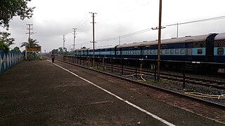
Lekhapani is a railway station on the Lumding–Dibrugarh section. It is located in Tinsukia district in the Indian state of Assam.

Bangarapet Junction railway station, also known as Bangarapete Junction railway station is a double-line electrified railway station which is located in the heart of the city. It is one of the important railway stations in the Chennai Central–Bangalore City line where many people board and de-board for many purposes.

The 15909 / 15910 Avadh Assam Express is an express train operated by Northeast Frontier Railway that runs between Dibrugarh railway station of Dibrugarh, Assam and Lalgarh Junction of Bikaner, Rajasthan in India.

Jalpaiguri Road railway station is one of the four railway station serving Jalpaiguri city in Jalpaiguri district in the Indian state of West Bengal. The others are: Jalpaiguri City, Mohitnagar/Jalpaiguri Halt, and Raninagar Jalpaiguri Junction railway station. Jalpaiguri is a newly built station, connecting the Barauni–Guwahati line and the New Mal–New Changrabandha–New Cooch Behar line. Jalpaiguri Road Railway Station (JPE) established in the yera of 1964. Operated by Northeast Frontier Railway. Jalpaiguri Road Railway Station (JPE) is located almost in the middle of the district. The nearest road to Jalpaiguri Road station is "Jalpaiguri - Siliguri State highway" and Four-lane East-West Corridor at a distance of 1 km. This station is part of the re-development project under Amrit Bharat Station Scheme.

New Alipurduar is one of the four railway stations that serve Alipurduar city in Alipurduar district in the Indian state of West Bengal. Its station code is NOQ. The other three adjacent railway stations are Alipurduar Junction, Alipurduar Court and Alipurduar .

