Novogrudok or Navahrudak is a town in Grodno Region, Belarus. It serves as the administrative center of Novogrudok District. As of 2023, it has a population of 28,021.

Ashmyany or Oshmyany is a town in Grodno Region, Belarus. It is located 50 kilometres (31 mi) from Vilnius in Lithuania. The town serves as the administrative center of Ashmyany District. It lies in Ashmyanka's river basin.

Tauragė is an industrial city in Lithuania, and the capital of Tauragė County. In 2020, its population was 21,520. Tauragė is situated on the Jūra River, close to the border with the Kaliningrad Oblast, and not far from the Baltic Sea coast.

Panevėžys is the fifth largest city in Lithuania. As of 2021, it occupies 50 square kilometres (19 sq mi) with 89,000 inhabitants. As defined by Eurostat, the population of the Panevėžys functional urban area, that stretches beyond the city limits, is estimated at 127,471.

Plungė is a city in Lithuania with 17,252 inhabitants. Plungė is known for Plungė Manor and its park, where the Samogitian Art Museum is located. In the Oginskiai manor park stands the Perkūnas oak natural monument. The Lourdes of Plungė was created in 1905 and attracts visitors to this day. In the center of Plungė stands a monument for the 10th anniversary of regaining the independence of Lithuania and a sculpture of Saint Florian built by the Lithuanian book carrier Kazys Barzdys.

Kretinga is a City in Klaipėda County, Lithuania. It is the capital of the Kretinga district municipality. It is located 12 km (7.5 mi) east of the popular Baltic Sea resort town of Palanga, and about 25 km (16 mi) north of Lithuania's 3rd largest city and principal seaport, Klaipėda.

Lyepyel or Lepel is a town in Vitebsk Region, Belarus, located near Lyepyel Lake on the Vula River. It serves as the administrative center of Lyepyel District. Its population in the 1998 census was 19,400. As of 2023, it has a population of 17,182.

Vepriai is the largest town in Ukmergė district, Lithuania, situated south-west of Ukmergė with population of about 549 (2011). The capital of Vepriai elderate.

The Catholic Church in Lithuania is part of the worldwide Catholic Church, under the spiritual leadership of the Pope in Rome. Lithuania is the world's northernmost Catholic majority country. Pope Pius XII gave Lithuania the title of "northernmost outpost of Catholicism in Europe" in 1939.
Krynkipronounced[ˈkrɨŋkʲi] is a town in northeastern Poland, located in Podlaskie Voivodeship along the border with Belarus. It lies approximately 24 kilometres (15 mi) south-east of Sokółka and about 45 km (28 mi) east of the regional capital Białystok.

Ramygala is a town in Lithuania. It is located some 24 km (15 mi) south from Panevėžys on the banks of the Upytė River, a tributary to the Nevėžis River. According to 2017 estimate, it had 1,440 residents.

Šeduva is a town in the Radviliškis district municipality, Lithuania. It is located 18 km (11 mi) east of Radviliškis.

Simnas is small town on the river Dovinė between Simnas and Giluitis lakes, in Alytus district, Alytus county, in the south of Lithuania. It lies on the 131 a national primary road from Alytus to Kalvarija. Simnas located within the ethnographical region Dzūkija. According to the 2022 data, 1209 people live in the town with 3148 in Simnas eldership. It is most populous settlement in Alytus district.

Veisiejai is a town in the Lazdijai district municipality, Lithuania. It is located 18 km (11 mi) south-east of Lazdijai. The Esperanto language was created in Veisiejai where L. L. Zamenhof started his practice as an ophthalmologist in 1885. There is a church dedicated to St. George, an old estate with a park, high school, kindergarten "Ąžuoliukas", a post office, a museum and monuments dedicated to the composer J. Neimontas and L. L. Zamenhof.

Kodeń is a village in eastern Poland on the Bug River, which forms the border between Poland and Belarus. Administratively, it belongs to Biała Podlaska County in Lublin Voivodeship. It is the seat of the gmina called Gmina Kodeń. It has approximately 1,900 inhabitants. It lies approximately 37 kilometres (23 mi) south-east of Biała Podlaska and 102 km (63 mi) north-east of the regional capital Lublin. The village is the site of a famous Marian shrine.
Valkininkai is a historic town in Valkininkų (Valkininkai) eldership, Varėna District Municipality, Alytus County, Lithuania, located about 22 km (14 mi) northeast from Varėna and about 55 km (34 mi) southwest from Vilnius. At the Lithuanian census of 2001, its population was 238 and at the census of 2011 it was 229.

Nemėžis is a village in the Vilnius district municipality, Lithuania, it is located only about 1 kilometre (0.62 mi) east of Vilnius. It is located south-east of Vilnius along a railway.

Kruonis is a small town, located 37 km (23 mi) east of Kaunas, in Kaunas County, central Lithuania. The name of Kruonis comes from a small creek Kruonė. In 2011 it had a population of 661. The center of Kruonis is a state-protected urbanistic monument. The only in the Baltic States Kruonis Pumped Storage Plant is situated 3 km (1.9 mi) north of Kruonis. Each year a music festival Renesanso naktys Kruonyje takes place in the church where the classical music of the composers of 16th-17th centuries being performed.
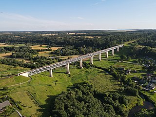
Lyduvėnai is a small town in the Šiluva Eldership, Raseiniai District Municipality, Kaunas County in central Lithuania. The town is 15 km north of Raseiniai and is near the confluence of the Dubysa and Dratvuo rivers. Lyduvėnai is the home of the longest and highest railway bridge in Lithuania, the Lyduvėnai Bridge. The town possesses the eldership's center, has a railway stop, a school, a library, in addition to post. The town's postal code is LT-60046. Lyduvėnai is situated in the Dubysa regional park and has its information center in the town's school. The railway line Šiauliai–Tilžė and the highways to Raseiniai and Šiluva pass through Lyduvėnai. Lyduvėnai is in the Dubysa valley, in contrast to other towns in the Dubysa basin.

Lentvaris Manor is a former residential manor in Lentvaris, Trakai District Municipality, Lithuania.