Zambia, officially the Republic of Zambia, is a landlocked country at the crossroads of Central, Southern and East Africa. It is typically referred to being in South-Central Africa or Southern Africa. Its neighbours are the Democratic Republic of the Congo to the north, Tanzania to the north-east, Malawi to the east, Mozambique to the southeast, Zimbabwe and Botswana to the south, Namibia to the southwest, and Angola to the west. The capital city of Zambia is Lusaka, located in the south-central part of Zambia. The population is concentrated mainly around Lusaka in the south and the Copperbelt Province to the north, the core economic hubs of the country.
The history of Zambia experienced many stages from colonization to independence from Britain on October 24, 1964. Northern Rhodesia became a British sphere of influence in the present-day region of Zambia in 1888, and was officially proclaimed a British protectorate in 1924. After many years of suggested mergers, Southern Rhodesia, Northern Rhodesia, and Nyasaland were merged into the British Federation of Rhodesia and Nyasaland.

Lake Mweru is a freshwater lake on the longest arm of Africa's second-longest river, the Congo. Located on the border between Zambia and Democratic Republic of the Congo, it makes up 110 kilometres (68 mi) of the total length of the Congo, lying between its Luapula River (upstream) and Luvua River (downstream) segments.

The Luapula River is a section of Africa's second-longest river, the Congo. It is a transnational river forming for nearly all its length part of the border between Zambia and the DR Congo. It joins Lake Bangweulu to Lake Mweru and gives its name to the Luapula Province of Zambia.

Livingstone is a city in Zambia. Until 1935, it served as the capital city of Zambia. Lying 10 km (6.2 mi) to the north of the Zambezi River, it is a tourism attraction center for the Victoria Falls and a border town with road and rail connections to Zimbabwe on the other side of the Victoria Falls. A historic British colonial city, its present population was enumerated at 177,393 inhabitants at the 2022 census. It is named after David Livingstone, the Scottish explorer and missionary who was the first European to explore the area.
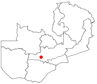
Mumbwa is a town in the Central Province of Zambia, lying on the M9 Road. Its district covers the western part of the Central Province bordering Kaoma and Western Province to the west, Namwala and Southern Province to the south, Lusaka and Lusaka Province to the east, Kasempa and North-Western Province to the north and Kabwe to the north-east. It is known for its cotton and has a ginnery. The Zambia Air Force has a base in the district. Kafue National Park borders the district to the west. The predominant tribes are the Ila, who speak a dialect known as Sala, mostly to the south and south east and the Kaonde to the north. The Lenje are to the north-east on the border area with Kabwe. There are also relatively large settlement of people from the west and north west such as the Lozi, Nkoya and Luvale, Shona people from the then Southern Rhodesia who settled there as refugees from the civil war in that country and who are now almost integrated and Tonga from the south. A lot of prospecting for minerals such as copper and gold was done in the district and small scale mines operated there. Most are now closed, though the gold mine at Luiri has been revived.

Central Province is one of Zambia's ten provinces. The provincial capital is Kabwe, which is the home of the Mulungushi Rock of Authority. Central Province has an area of 94,394 km (58,654 mi). It borders eight other provinces and has eleven districts. The total area of forest in the province is 9,095,566 ha, and it has a national park and three game management areas. The first mine in the region was opened up in 1905 making the then Broken Hill town the first mining town. In 1966, he town's name was reverted to its indigenous name - Kabwe meaning 'ore' or 'smelting'.

The Bemba belong to a large group of Bantu peoples mainly in the Northern, Luapula, Muchinga, and the northern Central Province of Zambia. The Bemba entered modern-day Zambia before 1740 by crossing the Luapula River from Kola. A few other ethnic groups in the Northern and Luapula regions of Zambia speak languages that are similar to Bemba but do not share a similar origin. The Bemba people are not indigenous to the Copperbelt Province, having reached there only in the 1930s due to employment opportunities in copper mining.
Water transport and the many navigable inland waterways in Zambia have a long tradition of practical use except in parts of the south. Since draught animals such as oxen were not heavily used, water transport was usually the only alternative to going on foot until the 19th century. The history and current importance of Zambian waterways, as well as the types of indigenous boats used, provide information on this important aspect of Zambian economy.
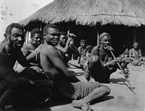
The Tonga people of Zambia and Zimbabwe are a Bantu ethnic group of southern Zambia and neighbouring northern Zimbabwe, and to a lesser extent, in Mozambique. They are related to the Batoka who are part of the Tokaleya people in the same area, but not to the Tonga people of Malawi. In southern Zambia they are patrons of the Kafue Twa. They differ culturally and linguistically from the Tsonga people of South Africa and southern Mozambique.
The following outline is provided as an overview of and topical guide to Zambia:
Zambia, officially known as the Republic of Zambia, is a landlocked country in Southern Africa. The neighbouring countries are the Democratic Republic of the Congo to the north, Tanzania to the north-east, Malawi to the east, Mozambique, Zimbabwe, Botswana, and Namibia to the south, and Angola to the west. The capital city is Lusaka, located in the southeast of the country. The population is concentrated mainly around the capital and the Copperbelt to the northwest.

Lusaka is the capital and largest city of Zambia. It is one of the fastest-developing cities in southern Africa. Lusaka is in the southern part of the central plateau at an elevation of about 1,279 metres (4,196 ft). As of 2019, the city's population was about 3.3 million, while the urban population is estimated at 2.5 million in 2018. Lusaka is the centre of both commerce and government in Zambia and connects to the country's four main highways heading north, south, east, and west. English is the official language of the city administration, while Bemba, Tonga, Lenje, Soli, Lozi, and Nyanja are the commonly spoken street languages.

Chibombo District is a district of Central Province, Zambia. As of the 2010 Zambian Census, the district had a population of 293,765 people. It consists of two constituencies, namely Keembe and Katuba.

Namwala District is a district of Zambia, located in Southern Province. The capital lies at Namwala. As of the 2000 Zambian Census, the district had a population of 82,810 people.

The Twa are a group of indigenous African Pygmy tribes.
Soli is a Bantu language of Zambia. It is part of the Botatwe group, who live mainly in Lusaka province and Central Province together with the Tonga and Lenje people
The Ila people are an ethnic group in The Republic of Zambia who make up 0.8 percent of the total population.

Bangweulu Twa, or the BaTwa of the Bangweulu swamps, are one of several groups of Twa living in Zambia. Others are Kafwe Twa and Lukanga Twa. They are also known by the names BaTwa or Abatwa. While other Twa groups that are scattered across equatorial Africa are described as pygmy groups and averaging about 1.5 m in height, the Bangweulu Twa are described as taller and at least partly of Bantu origin but they may be the descendants of former hunter-gatherer groups.
Kafubu is a river in the Haut-Katanga Province, Democratic Republic of the Congo. It gives its name to a health zone.