
A sinkhole is a depression or hole in the ground caused by some form of collapse of the surface layer. The term is sometimes used to refer to doline, enclosed depressions that are locally also known as vrtače and shakeholes, and to openings where surface water enters into underground passages known as ponor, swallow hole or swallet. A cenote is a type of sinkhole that exposes groundwater underneath. Sink and stream sink are more general terms for sites that drain surface water, possibly by infiltration into sediment or crumbled rock.
The Woodville Karst Plain is a 450-square-mile (1,200 km2) karst area that runs from Tallahassee, Florida, U.S. to the Gulf of Mexico separated by the Cody Scarp.
The Woodville Karst Plain Project or WKPP, is a project and organization that maps the underwater cave systems underlying the Woodville Karst Plain. This plain is a 450-square-mile (1,200 km2) area that runs from Tallahassee, Florida, U.S. to the Gulf of Mexico and includes numerous first magnitude springs, including Wakulla Springs, and the Leon Sinks Cave System, the longest underwater cave in the United States. The project grew out of a cave diving research and exploration group established in 1985 and incorporated in 1990.
The Floridan aquifer system, composed of the Upper and Lower Floridan aquifers, is a sequence of Paleogene carbonate rock which spans an area of about 100,000 square miles (260,000 2) in the southeastern United States. It underlies the entire state of Florida and parts of Alabama, Georgia, Mississippi, and South Carolina.

Wes Skiles Peacock Springs State Park is a 733-acre (297 ha) Florida State Park located on Peacock Springs Road, two miles (3 km) east of Luraville and on State Road 51, 16 miles (26 km) southwest of Live Oak, Florida. Activities include picnicking, swimming and diving, and wildlife viewing. Among the wildlife of the park are deer, bobcats, raccoon, squirrels, beaver and otters, as well as turkey, blue heron and barred owls. The park name commemorates the work of diver and explorer Wes Skiles. Prior to 2010 the park was known as Peacock Springs State Park. Amenities include a nature trail, six sinkholes, and Peacock and Bonnet Springs, with miles of underwater caves popular with cave divers. The two springs are tributaries of the Suwannee River. The park is open from 8:00 am till sundown year round.

The Cody Scarp or Cody Escarpment is located in north and north central Florida United States. It is a relict scarp and ancient persistent topographical feature formed from an ancient early Pleistocene shorelines of ~1.8 million to 10,000 years BP during interglacial periods. The Cody Scarp has a slope of 5% to 12%.

Wakulla Springs is located 14 miles (23 km) south of Tallahassee, Florida and 5 miles (8.0 km) east of Crawfordville in Wakulla County, Florida at the crossroads of State Road 61 and State Road 267. It is protected in the Edward Ball Wakulla Springs State Park.

Harrison Spring is the largest spring in the U.S. state of Indiana. It is located in west-central Harrison County, near the Blue River and just north of White Cloud.

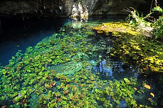
Dos Ojos is part of a flooded cave system located north of Tulum, on the Caribbean coast of the Yucatán Peninsula, in the state of Quintana Roo, Mexico. The exploration of Dos Ojos began in 1987 and still continues. The surveyed extent of the cave system is 82 kilometers (51 mi) and there are 28 known sinkhole entrances, which are locally called cenotes. In January 2018, a connection was found between Sistema Dos Ojos and Sistema Sac Actun. The smaller Dos Ojos became a part of Sac Actun, making the Sistema Sac Actun the longest known underwater cave system in the world.

The Big Bend of Florida, United States, is an informally-named geographic region of North Florida where the Florida Panhandle transitions to the Florida Peninsula south and east of Tallahassee. The region is known for its vast woodlands and marshlands and its low population density relative to much of the state. The area is home to the largest single spring in the United States, the Alapaha Rise, and the longest surveyed underwater cave in the United States, the 32-mile (51 km) Wakulla-Leon Sinks cave system.
Sistema Sac Actun is an underwater cave system situated along the Caribbean coast of the Yucatán Peninsula with passages to the north and west of the city of Tulum. Discovery of a connection to the Sistema Dos Ojos in 2018 made it the longest known underwater cave system. As of January 2023, it the second longest underwater cave system in the world only surpassed by Ox Bel Ha
Karst Underwater Research (KUR) is a registered 501(c)(3) non-profit organization that specializes in the research and documentation of karst aquifers and their corresponding surface features. KUR members perform a variety of scientific processes, including mapping and cartography, radio location, photography, videography, YSI water analysis and sampling.

Grassy Cove is an enclosed valley in Cumberland County, Tennessee, United States. The valley is notable for its karst formations, which have been designated a National Natural Landmark. Grassy Cove is also home to a small unincorporated community.
Global Underwater Explorers (GUE) is a scuba diving organization that provides education within recreational, technical, and cave diving. It is a nonprofit membership organization based in High Springs, Florida, United States.
Jarrod Michael Jablonski is a pioneering technical diver and record setting cave diver as well as an accomplished business owner and operator. These business operations include Halcyon Manufacturing, Extreme Exposure Adventure Center and Global Underwater Explorers. In July 2021 Jablonski launched and now operates the world's deepest pool at Deep Dive Dubai. Jablonski is one of the main architects behind the 'Doing It Right' system of diving.
Edward Ball Wakulla Springs State Park is a Florida State Park in Wakulla County, Florida, United States. This 6,000 acre (24 km2) wildlife sanctuary, located south of Tallahassee, is listed on the National Register of Historic Places, and designated a National Natural Landmark.

The Butler Cave Conservation Society (BCCS) is a 501(c)(3) non-profit Virginia corporation dedicated to the conservation, exploration, survey, preservation, and scientific study of the caves and karst in and around Burnsville Cove, Virginia.
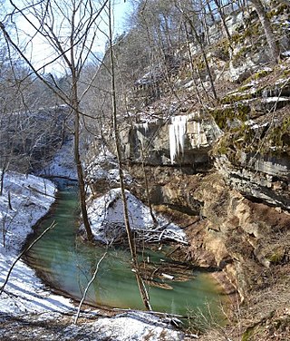
Cedar Sink is a vertical-walled large depression, or sinkhole, in the ground, that is located in Edmonson County, Kentucky and contained within and managed by Mammoth Cave National Park. The sinkhole measures 300 feet (91.4 m) from the top sandstone plateau to the bottom of the sink and was caused by collapse of the surface soil. The landscape is karst topography, which means the region is influenced by the dissolution of soluble rocks. Sinkholes, caves, and dolines typically characterize these underground drainage systems. Cedar Sink has a bottom area of about 7 acres (2.8 ha) and has more fertile soil compared to the ridgetops.

Cave diving is underwater diving in water-filled caves. The equipment used varies depending on the circumstances, and ranges from breath hold to surface supplied, but almost all cave diving is done using scuba equipment, often in specialised configurations with redundancies such as sidemount or backmounted twinset. Recreational cave diving is generally considered to be a type of technical diving due to the lack of a free surface during large parts of the dive, and often involves planned decompression stops. A distinction is made by recreational diver training agencies between cave diving and cavern diving, where cavern diving is deemed to be diving in those parts of a cave where the exit to open water can be seen by natural light. An arbitrary distance limit to the open water surface may also be specified. Despite the risks, water-filled caves attract scuba divers, cavers, and speleologists due to their often unexplored nature, and present divers with a technical diving challenge.

