Leonardville, Namibia

Last updated
Leonardville
Naosanabis
Wesley Vale
LeonardvilleBirdView.jpg
Bird's eye view of Leonardville (October 2015)
Namibia location map.svg
Red pog.svg
Leonardville
Location in Namibia
Coordinates: 23°30′S18°48′E / 23.500°S 18.800°E / -23.500; 18.800
CountryFlag of Namibia.svg  Namibia
Region Omaheke Region
Constituency Aminuis Constituency
Time zone UTC+2 (SAST)
Climate BWh

Leonardville is a village in eastern Namibia, situated on the Nossob River in the south-western corner of the Omaheke Region. It belongs to the Aminuis electoral constituency. [1]

Contents

Leonardville was the main settlement of the Khaiǁkhaun (Khauas Nama) subtribe of the Oorlam people until their military defeat against Imperial Germany's Schutztruppe soldiers in 1894 and 1896. [2]

History

The area around Leonardville was inhabited by the Taa-speaking subtribe of the San people until the Khaiǁkhaun (Red Nation), who called the place Naosanabis, occupied their land. [3] Around 1840 the group around Amraal Lambert, first Kaptein of the Kaiǀkhauan Orlam, moved into the area. They had been granted residence and pasture in the land of the Red Nation at an annual fee. [4] In 1843 the Wesleyan Missionary Society established a missionary station here; its first missionaries were Joseph Tindall and his son Henry. [5] They named the settlement Wesley Vale. In 1855 the Rhenish Missionary Society took over the operations. They bought the existing buildings—the church, the pastor's house, and the forge—and began to run a school for 60 to 80 children. [6] Amraal Lambert's group, however, searched for a different place to settle. They moved to Gobabis in 1855 [7] or 1856. [6]

Amraal Lambert and most of his family died from smallpox in 1864. Some time after that the Kaiǀkhauan, now under the leadership of Amraal's grandson Andreas, moved back to Naosanabis. From here they controlled important trade routes. Using their technological advantage of commanding firearms and horses, they waylaid and robbed merchants. In the 1880s the Kaiǀkhauan were considered a powerful and dangerous force. [2]

When Imperial Germany colonised the area a decade later, Lambert refused to sign a "protection treaty". Regarding the Kaiǀkhauan as a comparatively weak force, the German commander, Theodor Leutwein mounted a surprise attack on Naosanabis on 6 March 1894 in order to set an example for the stronger forces in then German South-West Africa not to stand in his way. [7]

The Schutztruppe forces won the battle and expelled the village's residents. The land was given to Angola Boers , [2] farmers who participated in the Dorsland Trek migration movement from South Africa to Angola but decided to turn around and settle in South-West Africa. [8] After the Herero and Namaqua Genocide 1904/05, Isaak Witbooi of the ǀKhowesin (Witbooi Orlam) moved to Naosanabis—the Kaiǀkhauan clan had at that time ceased to exist due to the devastating attack by the Germans. [2] During South African administration the settlement was renamed to Leonardville after Dutch Reformed Church Minister Leonard. [9]

Geography

Leonardville is situated on the ephemeral Nossob River in the south-western corner of the Omaheke Region.

The place normally receives an annual average rainfall of 236 millimetres (9.3 in), although in the 2010/2011 rainy season 530 millimetres (21 in) were measured. [10]

People

Despite the encroachment of Tswana, Orlams, and Boers, there is still a considerable San population. Of the estimated 500 remaining Taa speakers in Namibia, over 50 reside in Leonardville. [3]

Economy and infrastructure

The C20 regional road leads past Leonardville.

The main economic activity in the area is cattle farming. [11]

Headspring Investments, the Namibian subsidiary of Uranium One, which in turn is owned by the Russian Rosatom, was prospecting for Uranium in the area and had opened an office in the village. [12] Prospecting activities came to a halt in 2022 when government banned in situ mining and exploration drilling in or near important aquifers. [11]

Politics

Leonardville is governed by a village council that has five seats. [13]

In the 2010 local election in the village, the ruling SWAPO party won three of the five seats on the village's local council. The Rally for Democracy and Progress (RDP) and the National Unity Democratic Organisation (NUDO) each won a single seat. [14] The 2015 local authority election ended with the same result, three seats for SWAPO, and one each for NUDO and RDP. [15] SWAPO also won the 2020 local authority election with 336 votes and three village council seats. One seat each went to the Landless People's Movement (LPM, a new party registered in 2018, 151 votes) and NUDO (60 votes). [16]

Dutch Reformed Church

The Dutch Reformed Church Leonardville (formerly known as NGK Leonard) was founded on the eleventh day of the eleventh month of 1944 (November 11) as the eleventh church of the Dutch Reformed Church in South Africa (NGK) in what was then South West Africa. Members named it after one of the church's local pioneers, the Rev. (and later Dr.) E.J. Leonard, who ministered across the vast plains on donkey carts and even reached some isolated farms on foot. Founded by around 500 members of the Dutch Reformed Church Gibeon, the congregation grew to a thousand within eight years. By 2010, rural depopulation had reduced the number to a mere 176.

The congregation occupied an area of 25,000 square kilometres (9,700 sq mi) at its foundation. The resulting sprawl was alleviated somewhat by the secession of the Dutch Reformed Church Aroab in 1955. There was originally no congregational seat, so by 1952 it effectively consisted of four different wards, namely Uhlenhorst (140 members), Blumfelde (about 140 members), Aroab (about 360 members), and Pretorius (about 320 members). The parsonage was in Pretorius, and each ward had its own church hall where services were held once a month and communion offered twice a year.

Notable people

Related Research Articles

<span class="mw-page-title-main">Windhoek</span> Capital and largest city of Namibia

Windhoek is the capital and largest city of Namibia. It is located in central Namibia in the Khomas Highland plateau area, at around 1,700 m (5,600 ft) above sea level, almost exactly at the country's geographical centre. The population of Windhoek, which was 486,169 in 2023, is constantly growing due to a continued migration from other regions in Namibia.

<span class="mw-page-title-main">Gobabis</span> City in Omaheke Region, Namibia

Gobabis is a town in eastern Namibia. It is the regional capital of the Omaheke Region, and the district capital of the Gobabis electoral constituency. Gobabis is situated 200 km (120 mi) down the B6 motorway from Windhoek to Botswana. The town is 113 km (70 mi) from the Buitepos border post with Botswana, and serves as an important link to South Africa on the tarred Trans-Kalahari Highway. Gobabis is in the heart of the cattle farming area. In fact Gobabis is so proud of its cattle farming that a statue of a large Brahman bull with the inscription "Cattle Country" greets visitors to the town. Gobabis also has its own local airport.

<span class="mw-page-title-main">Berseba</span> Village in ǁKaras Region, Namibia

Berseba is a village in the ǁKaras Region of southern Namibia and the district capital of the Berseba electoral constituency. It is situated 100 km (62 mi) north-west of Keetmanshoop near the Brukkaros Mountain, a famous tourist destination.

<span class="mw-page-title-main">Bethanie, Namibia</span> Village in ǁKaras Region, Namibia

Bethanie is a village in the ǁKaras Region of southern Namibia. It is one of the oldest settlements in the country. Bethanie is situated on the C14 road between Goageb and Walvis Bay, 100 km west of Keetmanshoop. It has a population of about 2,000.

<span class="mw-page-title-main">Oorlam people</span> Ethnic group from southern Africa

The Oorlam or Orlam people are a subtribe of the Nama people, largely assimilated after their migration from the Cape Colony to Namaqualand and Damaraland.

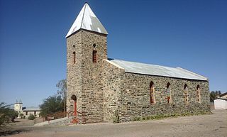
Gibeon is a village in Gibeon Constituency in the Hardap Region of Namibia.

<span class="mw-page-title-main">Aroab</span> Village in the ǁKaras Region of Namibia

Aroab is a village with a population of approximately 5,000 in the ǁKaras Region of southern Namibia. It is situated about 170 kilometres (110 mi) south-east of Keetmanshoop on the edge of the Kalahari desert; the average annual rainfall is about 150–200 mm. Aroab is the district centre of the Keetmanshoop Rural electoral constituency.

<span class="mw-page-title-main">Aminuis Constituency</span> Electoral constituency in the Omaheke region of eastern Namibia

Aminuis Constituency is an electoral constituency in the Omaheke Region of Namibia. It had 12,343 inhabitants in 2004 and 7,847 registered voters in 2020. The district capital is the settlement of Aminuis. The constituency forms part of the border between Namibia and Botswana.

<span class="mw-page-title-main">Jonker Afrikaner</span> Namibian politician (1785–1861)

Jonker Afrikaner was the fourth Captain of the Orlam in South West Africa, succeeding his father, Jager Afrikaner, in 1823. Soon after becoming Kaptein, he left his father's settlement at Blydeverwacht with three brothers and some 300 followers and relocated to the area that is today central Namibia. From 1825 onwards he and his council played a dominant political role in Damaraland and Namaland, creating a de facto state.

Hermann Heinrich Vedder was a German missionary, linguist, ethnologist and historian. Originally a silk weaver, he received missionary training by the Rhenish Missionary Society in Barmen between 1894 and 1903, whereafter he was sent to German South West Africa in 1905 and worked as a missionary and teacher trainer until his retirement, first for the black workers and prisoners-of-war in Swakopmund, then at the small mission station Gaub in the Otavi Mountains, and from 1922 onwards in Okahandja, where he taught at the Augustineum school.

<span class="mw-page-title-main">Aranos</span> Town in Hardap Region, Namibia

Aranos is a town in the Hardap Region of central Namibia, situated in the Nossob River basin in the Kalahari Desert.

<span class="mw-page-title-main">Witvlei</span> Village in Omaheke Region, Namibia

Witvlei is a village in the Okarukambe Constituency in the Omaheke Region of central-eastern Namibia. It is situated on the B6 150 kilometres (93 mi) from Windhoek on the way to Gobabis. It is known for producing high quality meat.

Andreas Lambert, also known as Andries Lambert, was the second Kaptein of the Kaiǀkhauan, a subtribe of the Orlam, in the eastern area of South-West Africa, today's Namibia.

Amraal Lambert, Nama name: ǂGaiǀnub, was the first Captain of the Kaiǀkhauan, a subtribe of the Orlam, in the eastern area of Namaland, today's Namibia.

<span class="mw-page-title-main">Franz Heinrich Kleinschmidt</span>

Franz Heinrich Kleinschmidt (1812–1864) was a German missionary and linguist who worked in southern Africa, now in the region of Namibia. He founded the missionary station and town of Rehoboth and together with Carl Hugo Hahn set up the first Rhenish mission station to the Herero people in Gross Barmen. Kleinschmidt is known for his scientific work on the Nama language.

<span class="mw-page-title-main">Heinrich Schmelen</span> 19th-century German missionary and Bible translator

Reverend Johann Heinrich Schmelen, born Johann Hinrich Schmelen was a German missionary and linguist who worked in South Africa and South-West Africa. Traveling through the area of today's northern South Africa and central and southern Namibia he founded the mission stations at Bethanie and Steinkopf and discovered the natural harbour at Walvis Bay. Together with his wife Zara he translated parts of the Bible into Khoekhoegowab (Damara/Nama) and published a dictionary.

The Red Nation is the main subtribe of the Nama people in Namibia and the oldest Nama group speaking Khoekhoegowab, the language often called Damara/Nama.

<span class="mw-page-title-main">Manasse ǃNoreseb</span>

Manasse ǃNoreseb Gamab was the thirteenth Kaptein of the Khaiǁkhaun, a subtribe of the Nama people in Namibia, between 1880 and 1905. At the start of Imperial Germany's colonisation of South-West Africa, Manasse was one of the most powerful leaders in the area.

<span class="mw-page-title-main">Aminuis</span> Settlement in Omaheke Region, Namibia

Aminuis is a cluster of small settlements in the remote eastern part of the Omaheke Region of Namibia, located about 500 km east of Windhoek. It is the district capital of the Aminuis electoral constituency.

Cupido Witbooi, variations: Kido and Kiwitti Witbooi, Nama name: ǂA-ǁêib ǃGâmemab, was the first Kaptein of the ǀKhowesin, a subtribe of the Orlam of South-West Africa, present-day Namibia.

References

  1. Mauku, Iuze (23 November 2010). "Presidential Affairs Minister visits Leonardville". Namibian Broadcasting Corporation (NBC). Archived from the original on 20 July 2011. Retrieved 5 February 2011.
  2. 1 2 3 4 Shiremo, Shampapi (14 January 2011). "Captain Andreas Lambert: A brave warrior and a martyr of the Namibian anti-colonial resistance". New Era . Archived from the original on 8 December 2012. Retrieved 2 February 2011.
  3. 1 2 "Taa". Dokumentation bedrohter Sprachen (Documentation of Endangered Languages). Retrieved 5 February 2011.
  4. Vedder 1997, p. 177.
  5. Dierks, Klaus. "Chronology of Namibian History, 1843" . Retrieved 5 February 2011.
  6. 1 2 Vedder 1997, p. 325.
  7. 1 2 Dierks, Klaus. "Biographies of Namibian Personalities, L" . Retrieved 14 January 2011.
  8. "The Dorsland Trekkers". tourbrief.com. Retrieved 25 June 2010.
  9. Dierks, Klaus. "Biographies of Namibian Personalities, W" . Retrieved 5 February 2011.
  10. Menges, Werner (26 May 2011). "Rainy season was one for the record books". The Namibian . Archived from the original on 15 December 2011.
  11. 1 2 Ndjavera, Maihapa (25 January 2023). "Uranium One still hopeful for Leonardville mining…as company awaits new borehole drilling permits". New Era .
  12. Movirongo, Clifton (11 June 2023). "Russian State-owned Company Uranium Miner Opens Office in Leonardville Village-Set to Construct School Dining Hall". Namibia Economist .
  13. "Know Your Local Authority". Election Watch. No. 3. Institute for Public Policy Research. 2015. p. 4.
  14. SWAPO wins 3 seats in Leonardville Local Authority Namibian Broadcasting Corporation , 29 November 2010
  15. "Local elections results". Electoral Commission of Namibia. 28 November 2015. p. 5. Archived from the original on 10 December 2015.
  16. "2020 Local Authority Elections Results and Allocation of Seats" (PDF). Electoral Commission of Namibia. 29 November 2020. p. 12. Retrieved 25 January 2021.
  17. Jan de Wet Archived 2009-03-13 at the Wayback Machine at Who's Who in Southern Africa

Literature