Columbine is census-designated place (CDP) in and governed by Jefferson and Arapahoe counties in Colorado, United States. The CDP is a part of the Denver–Aurora–Lakewood, CO Metropolitan Statistical Area. Located primarily in Jefferson County, Columbine lies immediately south of Denver. The population of the Columbine CDP was 24,280 at the United States Census 2010. The community lies in ZIP code 80123.
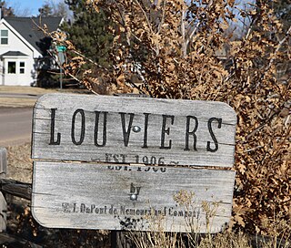
Louviers is an unincorporated town, a post office, and a census-designated place (CDP) located in and governed by Douglas County, Colorado, United States. The CDP is a part of the Denver–Aurora–Lakewood, CO Metropolitan Statistical Area. The Louviers post office has the ZIP Code 80131. At the United States Census 2010, the population of the Louviers CDP was 269, while the population of the 80131 ZIP Code Tabulation Area was 243.

Sedalia is an unincorporated town, a post office, and a census-designated place (CDP) located in and governed by Douglas County, Colorado, United States. The CDP is a part of the Denver–Aurora–Lakewood, CO Metropolitan Statistical Area. The Sedalia post office has the ZIP Code 80135. At the United States Census 2010, the population of the Sedalia CDP was 206, while the population of the 80135 ZIP Code Tabulation Area was 3,833 including adjacent areas.

Kittredge is an unincorporated town, a post office, and a census-designated place (CDP) located in and governed by Jefferson County, Colorado, United States. The CDP is a part of the Denver–Aurora–Lakewood, CO Metropolitan Statistical Area. The Kittredge post office has the ZIP code 80457. At the United States Census 2010, the population of the Kittredge CDP was 1,304, while the population of the 80457 ZIP Code Tabulation Area was 612.

Leadville North is a census-designated place (CDP) in and governed by Lake County, Colorado, United States. The population of the Leadville North CDP was 1,794 at the United States Census 2010. The Leadville post office serves the area.
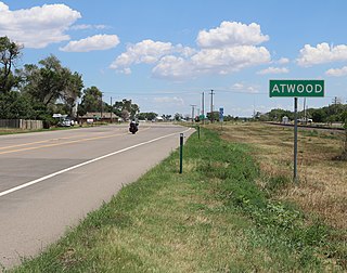
Atwood is an unincorporated town, a post office, and a census-designated place (CDP) located in and governed by Logan County, Colorado, United States. The CDP is a part of the Sterling, CO Micropolitan Statistical Area. The Atwood post office has the ZIP Code 80722. At the United States Census 2010, the population of the Atwood CDP was 133, while the population of the 80722 ZIP Code Tabulation Area was 349 including adjacent areas.

Clifton is a census-designated place (CDP) and post office in and governed by Mesa County, Colorado, United States. It is part of the Grand Junction, CO Metropolitan Statistical Area. The Clifton post office has the ZIP Code 81520. As of the 2020 census, the population of the Clifton CDP was 20,413.

Redlands is an unincorporated community and census-designated place (CDP) located in and governed by Mesa County, Colorado, United States. It is part of the Grand Junction, CO Metropolitan Statistical Area. The population of the Redlands CDP was 9,061 at the 2020 census. The Grand Junction post office serves the area.

Towaoc is a Census-designated place (CDP), a post office, and the capital of the Ute Mountain Ute Tribe located on the Ute Mountain Ute Reservation in Montezuma County, Colorado, United States. The Towaoc post office has the ZIP Code 81334. At the United States Census 2020, the population of the Towaoc CDP was 1,120.

Conejos is an unincorporated town, a post office, a census-designated place (CDP), and the county seat of Conejos County, Colorado, United States. The Conejos post office has the ZIP Code 81129. At the United States Census 2010, the population of the Conejos CDP was 58, while the population of the 81129 ZIP Code Tabulation Area was 156 including adjacent areas. Conejos is the only unincorporated county seat in the State of Colorado.

Capulin is an unincorporated town, a post office, and a census-designated place (CDP) located in and governed by Conejos County, Colorado, United States. The Capulin post office has the ZIP Code 81124. At the United States Census 2010, the population of the Capulin CDP was 200, while the population of the 81124 ZIP Code Tabulation Area was 565 including adjacent areas.

Idledale is an unincorporated town, a post office, and a census-designated place (CDP) located in and governed by Jefferson County, Colorado, United States. The CDP is a part of the Denver–Aurora–Lakewood, CO Metropolitan Statistical Area. The Idledale post office has the ZIP code 80453. At the United States Census 2020, the population of the Idledale CDP was 214.

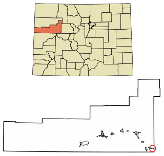
Maybell is an unincorporated community and census-designated place (CDP) in and governed by Moffat County, Colorado, United States. The CDP is a part of the Craig, CO Micropolitan Statistical Area.

Wolcott is an unincorporated town, a post office, and a census-designated place (CDP) located in and governed by Eagle County, Colorado, United States. The CDP is a part of the Edwards, CO Micropolitan Statistical Area. The Wolcott post office has the ZIP Code 81655. At the United States Census 2010, the population of the Wolcott CDP was 15, while the population of the 81655 ZIP Code Tabulation Area was 65 including adjacent areas.

Fairmount is an unincorporated community and a census-designated place (CDP) in Jefferson County, Colorado, United States. The CDP is a part of the Denver–Aurora–Lakewood, CO Metropolitan Statistical Area. The population of the Fairmount CDP was 7,559 at the United States Census 2010. ZIP code 80403 applies to addresses in Fairmount.

Glendale is an unincorporated community and a census-designated place (CDP) located in and governed by Boulder County, Colorado, United States. The CDP is a part of the Boulder, CO Metropolitan Statistical Area. The population of the Glendale CDP was 69 at the United States Census 2010. The Jamestown post office serves the area.

Cathedral is a census-designated place (CDP) located in and governed by Hinsdale County, Colorado, United States. The population of the Cathedral CDP was 14 at the United States Census 2010. The Powderhorn post office serves the area.
Catherine is a census-designated place (CDP) in and governed by Garfield County, Colorado, United States. The CDP is a part of the Glenwood Springs, CO Micropolitan Statistical Area. The population of the Catherine CDP was 228 at the United States Census 2010. The Glenwood Springs post office serves the area.

Cattle Creek is a census-designated place (CDP) in and governed by Garfield County, Colorado, United States. The CDP is a part of the Glenwood Springs, CO Micropolitan Statistical Area. The population of the Cattle Creek CDP was 641 at the United States Census 2010. The Glenwood Springs post office serves the area.

Stonewall Gap is an unincorporated community and a census-designated place (CDP) located in and governed by Las Animas County, Colorado, United States. The population of the Stonewall Gap CDP was 67 at the United States Census 2010. The Weston post office serves the area.