Division No. 8 is a census division on the north coast of the island of Newfoundland in the province of Newfoundland and Labrador, Canada. It has a land area of 9,314.57 km² and had a population of 33,940 at the 2016 census. Its largest communities are the towns of Lewisporte, Springdale, and Twillingate.

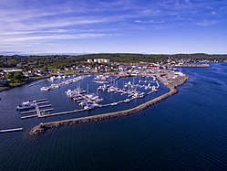
Twillingate is a town of 2,121 people located on the Twillingate Islands ("Toulinquet") in Notre Dame Bay, off the north eastern shore of the island of Newfoundland in the province of Newfoundland and Labrador, Canada. The town is about 100 kilometres (62 mi) north of Lewisporte and Gander.

Portugal Cove–St. Philip's is a rural seashore community located on the eastern Avalon Peninsula of Newfoundland in the province of Newfoundland and Labrador, Canada. The town is a bedroom community of the provincial capital of St. John's.

Boyd's Cove, also known as Boyd's Harbour, is a local service district and designated place in the Canadian province of Newfoundland and Labrador that is near Lewisporte. There is an interpretive centre dedicated to the earlier indigenous Beothuk settlement at this location.
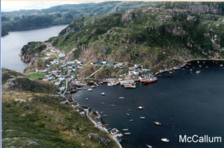
McCallum is a local service district and designated place in the Canadian province of Newfoundland and Labrador. McCallum is located on the southern coast of the island of Newfoundland. It is accessible only by boat or by air, and in appearance and way of life is thought by some to be as close to a pre-20th century community as may be found. McCallum lies in an enclosed harbour and is sheltered between two hills. The community survives primarily on the fishery. Whaling was also a major industry in the late 19th century. The provincial government runs a ferry service to McCallum from the nearby town of Hermitage, about an hour and a half away by boat, where the nearest road is located.

Rose Blanche – Harbour le Cou is a small town on Newfoundland's southwest shore, about 45 km at the end of Route 470 from Port aux Basques. This community is located in a barren area on the east side of a small bay. In this bay there are 2 harbours that were mainly used to provide shelter for fishing vessels. Scenery includes the rugged granite coastline, and the white and rocky cliffs of "Diamond Cove". Its granite lighthouse was in operation from 1873 to the 1940s. After it was abandoned in the 1940s the building fell into ruins. The spiral stone staircase extends into the tower wall and kept the tower from collapsing while the remainder of the lighthouse fell to ruin. In 1999 the lighthouse was fully reconstructed and serves as a tourist attraction.

Change Islands is an outport community in the Canadian province of Newfoundland and Labrador.
Hermitage-Sandyville is a small town on the south coast of Newfoundland, Canada, with a population of 404 people in the 2021 Census. The main source of income for the community is provided by the aquaculture industry, the local salmon plant and fishing.

Pool's Cove is a fishing village located on the north west side of Fortune Bay, on the South Coast of Newfoundland, Canada. The town had a population of 143 in the 2021 Census.
Baytona is a small rural community found in Newfoundland and Labrador. It is situated off of Route 340, which runs from Lewisporte to Twillingate island, aptly named "Road to the Isles". A bay separates Baytona from a neighboring town called Birchy Bay. The first settlers of Baytona were fishermen, with women mainly staying home to raise children; however, with a depletion in cod stocks and lobsters, there was a shift away from the fishing industry.

Burnt Islands is a small coastal community found in God Bay on the southwest coast of Newfoundland, Canada.
Embree is a small community just outside Lewisporte. It is a drive-through town that eventually leads into neighbouring Little Burnt Bay.
Little Burnt Bay is a small coastal community outside Embree and Lewisporte. In 2021, the population was 238, down 15.3 percent from 2016.

Comfort Cove-Newstead is a small fishing community located outside Campbellton, on the east coast of Newfoundland and Labrador, Canada,.
Lushes Bight–Beaumont–Beaumont North is a town on Long Island in Notre Dame Bay in the Canadian province of Newfoundland and Labrador. The town had a population of 169 at the 2021 Census, down from 275 in the 2006 Census.
Philips Head, or Phillips Head, is a local service district and designated place in the Canadian province of Newfoundland and Labrador. It is in the north-central portion of the island of Newfoundland. It is in the Bay of Exploits, west of Lewisporte and north of Botwood.
Horwood is a local service district and designated place in the Canadian province of Newfoundland and Labrador. It was formerly known as Dog Bay. It is located northeast of Lewisporte just off of Route 331. It was once the home of a bustling lumber company owned by the Horwood family. Dog Bay was renamed Horwood after the family name.
Gander Bay South is a local service district and designated place in the Canadian province of Newfoundland and Labrador. Gander Bay was a small place in the Fogo and Twillingate area in 1864. It was north of Gander. The way office opened in 1885 and the first waymaster was John Bursey. It became a post office on May 30, 1891, and the first postmaster was James Rowsell. It had no population after 1940. They moved to Gander Bay South.
Blaketown is a local service district and designated place in the Canadian province of Newfoundland and Labrador.
Gander Bay North is a local service district and designated place in the Canadian province of Newfoundland and Labrador.