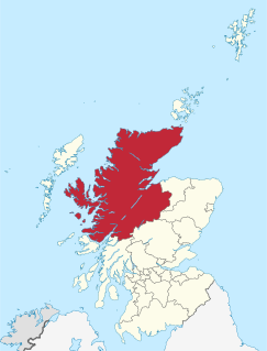
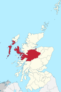
Highland is a council area in the Scottish Highlands and is the largest local government area in the United Kingdom. It was the 7th most populous council area in Scotland at the 2011 census. It shares borders with the council areas of Aberdeenshire, Argyll and Bute, Moray and Perth and Kinross. Their councils, and those of Angus and Stirling, also have areas of the Scottish Highlands within their administrative boundaries.

Inverness is a city in the Scottish Highlands. It is the administrative centre for The Highland Council and is regarded as the capital of the Highlands. Historically it served as the county town of the county of Inverness-shire. Inverness lies near two important battle sites: the 11th-century battle of Blàr nam Fèinne against Norway which took place on the Aird, and the 18th century Battle of Culloden which took place on Culloden Moor. It is the northernmost city in the United Kingdom and lies within the Great Glen at its northeastern extremity where the River Ness enters the Beauly Firth. At the latest, a settlement was established by the 6th century with the first royal charter being granted by Dabíd mac Maíl Choluim in the 12th century. Inverness and Inverness-shire are closely linked to various influential clans, including Clan Mackintosh, Clan Fraser and Clan MacKenzie.

Urquhart Castle, a ruin, sits beside Loch Ness in the Highlands of Scotland. The castle is on the A82 road, 21 kilometres (13 mi) south-west of Inverness and 2 kilometres (1.2 mi) east of the village of Drumnadrochit.

Culbokie is a small village in Ross and Cromarty, Highland, Scotland. It is located on the north side of the Black Isle. The village is 3 miles (5 km) south-east of Dingwall and about 9 miles (14 km) north of Inverness.

Drumnadrochit is a village in the Highland local government council area of Scotland, lying near the west shore of Loch Ness at the foot of Glen Urquhart. The village is close to several neighbouring settlements: the villages of Milton to the west, Kilmore to the east and Lewiston to the south. The villages act as a centre for regional tourism beside Loch Ness, as well as being a local economic hub for the nearby communities.

Glen Affric is a glen south-west of the village of Cannich in the Highland region of Scotland, some 15 miles west of Loch Ness. The River Affric runs along its length, passing through Loch Affric and Loch Beinn a' Mheadhoin. A minor public road reaches as far as the end of Loch Beinn a' Mheadhoin, but beyond that point only rough tracks and footpaths continue along the glen.

Francis William Ogilvy-Grant, 6th Earl of Seafield was a Scottish nobleman, a Member of Parliament and is listed as the 25th Chief of The Clan Grant.

John Charles Ogilvy-Grant, 7th Earl of Seafield KT, styled Viscount Reidhaven from 1840 to 1853, was a Scottish nobleman. He is numbered as the 26th Chief of Clan Grant.

The Great Glen Way is a long distance path in Scotland. It follows the Great Glen, running from Fort William in the southwest to Inverness in the northeast, covering 125 kilometres (78 mi). It was opened in 2002, and is designated as one of Scotland's Great Trails by NatureScot. The Great Glen Way is generally walked from southwest to northeast to follow the direction of the prevailing wind. It can be walked in 5–7 days, or cycled in 2–3 days. The trail is maintained and improved by the Great Glen Ways partnership, which consists of Highland Council, Scottish Canals and Forestry and Land Scotland. About 30,000 people use the path every year, of whom about 4,500 complete the entire route.

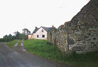
Balnain is a small village in Glenurquhart, Scotland, about 5 miles west of Drumnadrochit. It is mostly dependent on tourism, forestry, agriculture and farming. The first buildings were created in the 1870s and 1880s and minor expansions occurred in the 1900s, 1960s and 1970. Its height above sea level is 123.6m.

Croy is a village between Inverness and Nairn, in the Highland council area in Scotland. The village looks over the Moray Firth and is located a few miles from Inverness Airport. The estimated population of the village is 498 according to the adjusted 2011 census.

Bunloit is a village on the north western shore of Loch Ness in Inverness-shire, in the Scottish Highlands and is part of the Scottish council area of Highland.
Balbeg is a clachan (hamlet) about 0.5 miles (1 km) north-east of Balnain, 4 miles (6 km) west of Drumnadrochit, Inverness-shire and is in the Scottish council area of Highland.

Loch Ness is a large freshwater loch in the Scottish Highlands extending for approximately 37 kilometres southwest of Inverness. It takes its name from the River Ness, which flows from the northern end. Loch Ness is best known for alleged sightings of the cryptozoological Loch Ness Monster, also known affectionately as "Nessie". It is one of a series of interconnected, murky bodies of water in Scotland; its water visibility is exceptionally low due to a high peat content in the surrounding soil. The southern end connects to Loch Oich by the River Oich and a section of the Caledonian Canal. The northern end connects to Loch Dochfour via the River Ness, which then ultimately leads to the North Sea via the Moray Firth.

Inverfarigaig is a hamlet at the mouth of the River Farigaig, on the south-east shore of Loch Ness in Inverness-shire, Scottish Highlands and is in the Scottish council area of Highland.
Corrimony is a small village at the western end of Glenurquhart, in Inverness-shire, in the Highlands of Scotland, now within Highland council area. It is 13 km west of Drumnadrochit, and 32 km south-west of Inverness.
Inverness-shire is a historic county, registration county and lieutenancy area of Scotland. Covering much of the Highlands and Outer Hebrides, it is Scotland's largest county, though one of the smallest in population, with 67,733 people or 1.34% of the Scottish population.

Glenurquhart or Glen Urquhart is a glen running to the west of the village of Drumnadrochit in the Highland council area of Scotland.

Milton is a village in Glenurquhart, to the west of the village of Drumnadrochit, in the Highland council area of Scotland. It lies on the north side of the River Enrick, next to the A831 road.

Aird and Loch Ness is one of the 21 wards used to elect members of the Highland Council. It includes Loch Ness, the town of Beauly, and the village of Fort Augustus. It elects four Councillors.

