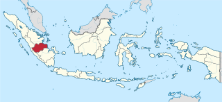
Jambi is a province of Indonesia. It is located on the east coast of central Sumatra and stretches to the Barisan Mountains in the west. Its capital and largest city is also called Jambi. It is bordered by the provinces of Riau to the north, West Sumatra to the west, Bengkulu to the southwest, South Sumatra to the south, and shares a maritime border with the Riau Islands to the east and the Pacific Ocean to the east. The province has a land area of 49,026.58 km2, and a sea area of 3,274.95 km2. Its area is comparable to the European country of Slovakia. It had a population of 3,092,265 according to the 2010 census and 3,548,228 according to the 2020 census; the official estimate of population as of mid-2023 was 3,679,169.

The Riau Islands is a province of Indonesia—not to be confused with neighbouring Riau Province from which the islands were separated in 2002. The capital of the province is Tanjung Pinang and the largest city is Batam. It shares a maritime border with Riau and Jambi to the east, Bangka Belitung Islands to the south, Singapore to the northeast, Malaysia and West Kalimantan to the west, and Vietnam and Cambodia to the north. It comprises a total of 1,796 islands scattered between Sumatra, Malay Peninsula, and Borneo including the Riau Archipelago. Situated on one of the world's busiest shipping lanes along the Malacca Strait and the Natuna Sea, the province shares water borders with neighboring countries such as Singapore, Malaysia, and Brunei. The Riau Islands also have relatively large potential mineral resources and energy, as well as marine resources.

Natuna Regency is an islands regency located in the northernmost part of the Province of Riau Islands, Indonesia. It contains at least 154 islands, of which 127 of them are reported as uninhabited. This archipelago, with a land area of 1,978.49 km2 out of a total area of 264,198.37 km2 area, contains 17 administrative districts (kecamatan).

Anambas Islands Regency is a small archipelago of Indonesia, located 150 nautical miles northeast of Batam Island in the North Natuna Sea between the Malaysian mainland to the west and the island of Borneo to the east. Geographically part of the Tudjuh Archipelago, it is administratively a regency within the Riau Islands Province. It covers a land area of 590.14 square kilometres (227.85 sq mi) and had a population of 37,411 at the 2010 Census and 47,402 at the 2020 Census; the official estimate as at mid 2023 was 49,090. The administrative centre is at Tarempa on Siantan Island.

Tanjungpinang, also colloquially written as Tanjung Pinang, is the capital city of the Indonesian province of Riau Islands. It covers a land area of 144.56 km2, mainly on the southern Bintan Island, as well as other smaller islands such as Dompak Island and Penyengat Island. With a population of 227,663 at the 2020 Census, it is the second largest city of the province, after Batam; the official estimate as at mid 2022 was 239,854. Tanjungpinang is a historic city of the Malay culture, having served as the capital of both Johor Sultanate and Riau-Lingga Sultanate.

Dumai, is a coastal city in Riau Province on the island of Sumatra, Indonesia. The city has an area of 2,066.72 km2 and had 331,832 inhabitants at mid 2022 official estimate. Dumai has a domestic airport, Pinang Kampai Airport. Dumai is an important transport and trade centre, both regionally and internationally, especially to Malaysia. Dumai is rich in oil.

Pesisir Selatan Regency is a regency (kabupaten) of West Sumatra Province of Indonesia. It has an area of 6,049.33 km² and a population of 429,246 at the 2010 Census and 504,418 at the 2020 Census; the official estimate as at mid-2023 was 525,355. The regency seat is at the town of Painan, in IV Jurai District.

Pandeglang Regency is a regency of Banten province, Indonesia. It is mainly located on the west and south coasts of the island of Java and is the most westerly regency on Java Island, but it also includes several offshore islands such as Panaitan, Deli and Tinjil. The regency has an area of 2,746.81 km2, and a population at the 2010 Census of 1,149,610, rising to 1,272,687 at the 2020 Census; the official estimate as of mid-2023 was 1,312,766 - comprising 672,828 males and 639,938 females. The regency seat is the town of Pandeglang in the northeast of the regency, but the most densely-populated district is the town of Labuan on the west coast.

Rokan Hilir is a regency (kabupaten) of Riau Province, on Sumatra island, Indonesia. It was formed on 4 October 1999 from districts which had previously been the northwestern part of Bengkalis Regency. It occupies the lower part of the catchment area of the Rokan River, and has an area of 8,851.59 km2. It had a population of 553,216 at the 2010 census and 637,161 at the 2020 census; the official estimate as at mid 2022 was 638,407. The administrative centre of the Rokan Hilir Regency is located at the town of Bagansiapiapi.

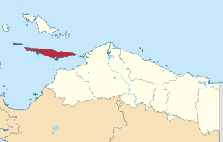
Bintan Regency is an administrative area in the Riau Islands Province of Indonesia. Bintan Regency includes all of Bintan Island and also includes many outlying islands including the Tambelan Archipelago and Badas Islands situated between Bintan and West Kalimantan.
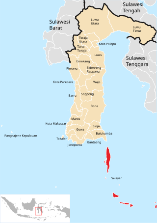
The Selayar Islands Regency is a regency of Indonesia in South Sulawesi province that covers the Selayar Islands, which lie southeast of the southern peninsula of Sulawesi. The archipelago consists of the group's main island, which is surrounded by 41 smaller islands around its coast; further to the southeast lies a widespread group of islands, including the smaller but still substantial islands of Pasimassunggu, Pasimarannu and Pasilambena in the far south, and the huge atoll of Takabonerate. The regency covers an area of 1,357.03 km2, and had a population of 103,596 at the 2000 Census, 122,055 at the Census of 2010 and 137,071 at that of 2020. The official estimate for mid 2023 was 142,100. The administrative centre is the town of Benteng on Selayar Island. The Selayar Straits separate the regency from Sulawesi island.

Singkep is an island in the Lingga Archipelago in Indonesia. Its area is 757 square kilometres (292 sq mi). It is separated from the east coast of Sumatra by the Berhala Strait. It is surrounded by islands Posik to the west, I. Serak to the SW, I. Lalang to the South, and I. Selayar of Riau Islands between Lingga and Singkep.

The Karimun Regency is located in the Riau Islands Province, Indonesia. Besides the central island of Great Karimun, the regency also includes the island of Kundur and over 240 lesser islands. The district covers a land area of 1,524 km2 and a sea area of 6,460 km2, and its population was 212,561 at the 2010 census and 253,457 at the 2020 census; the official estimate as at mid 2023 was 270,120.
Yapen Islands Regency is a regency (kabupaten) in Papua Province of eastern Indonesia. It covers an area of 2,432.49 km2 (939.19 sq mi), and had a population of 82,951 at the 2010 Census and 112,676 at the 2020 Census; the official estimate as at mid 2022 was 116,107. It comprises an archipelago which lies in Cenderawasih Bay off the north coast of Western New Guinea.

Meranti Islands is an archipelago, most of which forms a regency (kabupaten) of Riau Province and lies off the eastern coast of the island of Sumatra, Indonesia. It was created on 19 December 2008 by the separating of these large islands from the mainly mainland regency of Bengkalis. The regency comprises the islands of Tebing Tinggi, Rangsang, Padang, and Merbau, together with minor offshore islands, but does not include Bengkalis Island to the north, which is geographically part of the archipelago but remains within Bengkalis Regency. The principal town is Selat Panjang on Tebing Tinggi Island. The regency covers an area of 3,623.93 km2 and had a population of 176,290 at the 2010 Census and 206,116 at the 2020 Census; the official estimate as of mid-2023 was 211,771.
Morowali Regency is a regency of Central Sulawesi Province of Indonesia. It covers an area of 5,472 km2 and the districts now within the regency had a combined population of 102,228 at the 2010 Census; the regency population at the 2020 Census was 161,727; the official estimate as at mid 2023 was 170,450. The administrative centre is at the town of Bungku. The Regency includes the far-flung Menui Islands, lying to the southwest of the rest of the province.

Southwest Maluku Regency is a regency of Maluku Province, Indonesia. Geographically it forms the most eastern portion of the Lesser Sunda Islands, although it has never been administratively included with them, and politically has always comprised a part of the Maluku Province. It comprises a number of islands and island groups in the south of the province, including Lirang Island, Wetar Island, Kisar Island, Romang Island, the Letti Islands, the Damer Islands, the Sermata Islands and the Babar Islands. The total land area is 4,581.06 km2, and the population was 70,714 at the 2010 Census and 81,928 at the 2020 Census; the official estimate as at mid 2023 was 93,766.

Pesisir Barat Regency is a regency in Lampung Province of Indonesia. It was created on 25 October 2012 from the eight western districts of West Lampung Regency. It covers an area of 2,907.23 km2, and had a population of 141,741 at the 2010 Census and 162,697 at the 2020 Census; the official estimate as of mid-2023 was 174,695. The administrative center is the town of Krui. The majority group in the Pesisir Barat Regency is the Lampung people, while the Bengkulu language is also spoken in some districts.


