Linton, New Zealand

Last updated

Linton
Linton, New Zealand
CountryNew Zealand
City Palmerston North
Postcode(s)
4472
(Manawatū River) Linton Military Camp
Opiki
Pfeil oben.svg
Pfeil links.svgLintonPfeil rechts.svg
Pfeil unten.svg
Tokomaru

Linton is a suburb of Palmerston North, situated 11km south-west of the city.

Contents

The Linton Military Camp, the largest army camp in New Zealand, was built in 1945 3.5 kilometres to the south-east of Palmerston North. It became the country’s second largest base in 1985 when the permanent force at Singapore was relocated there. More units have transferred from Auckland and Waiouru. It features a community library, which is available to the local community.

Manawatu Prison is also located in Linton.

History

Linton is named for James Linton, an early settler in the area, and also twice Mayor of Palmerston North. The Scotsman was one of the first European settlers in Palmerston. He and his wife, Sarah, arrived on horseback from Wairarapa early in 1871. Linton served as mayor of Palmerston North 1879-82 and 1884-5, and was a director and ardent promoter of the Wellington and Manawatu Railway Company. [1]

The site of the original planned Linton township is several kilometres away from current army camp, at the location of a Wellington and Manawatu Railway Company station on the Wellington ‒ Longburn railway line. Along with several other directors of this private company, James Linton was honoured by having a railway station settlement on the line named after him. The line, opened in 1886, was a successful venture, but the Linton township did not develop. In 1889, a school was established, [2] and St Columba's Church, which serve the small farming community. [1]

The site of the Linton Military Camp was bought by the New Zealand Government in October 1941. Tents for the 2 Field Regiment formed the first accommodation on this site in February 1942, but within six months the first prefabricated huts were being built. The first housing blocks for officers were constructed in 1955. [1]

In 1985 Linton became New Zealand’s largest military camp, when the permanent force then stationed in Singapore was withdrawn and accommodated at Linton. It has grown even bigger since then with the transfer of frontline units from Auckland and Waiouru. The site purchased for Linton Military Camp included an area by the Manawatu River which had been a major Rangitane Maori village known as Te Kairanga (the place where much food is gathered) but by the 1940s the name was in common use for the district on the other side of the river. Instead the camp took the name of Linton. [1]

Prior to 1996, Linton was part of the Manawatu electorate. However, due to the reformation of the electoral system from FPP to MMP, the electorate of Palmerston North's boundaries were redrawn to include Linton. In 2007, the boundaries were redrawn and Linton was shifted into the Rangitikei electorate.

Until 2013, Linton was part of the Ashhurst-Fitzherbert Ward of Palmerston North City Council, alongside Aokautere and Turitea.

Demographics

Historical population
YearPop.±% p.a.
20061,089    
20131,185+1.21%
20181,227+0.70%
Source: [3]

Linton is part of the Pihauatua statistical unit, which covers 394.74 km2 (152.41 sq mi). [4] It had a population of 1,227 at the 2018 New Zealand census, an increase of 42 people (3.5%) since the 2013 census, and an increase of 138 people (12.7%) since the 2006 census. There were 414 households. There were 648 males and 582 females, giving a sex ratio of 1.11 males per female. The median age was 39.2 years (compared with 37.4 years nationally), with 261 people (21.3%) aged under 15 years, 225 (18.3%) aged 15 to 29, 603 (49.1%) aged 30 to 64, and 141 (11.5%) aged 65 or older.

Ethnicities were 88.5% European/Pākehā, 11.5% Māori, 1.7% Pacific peoples, 4.6% Asian, and 3.7% other ethnicities (totals add to more than 100% since people could identify with multiple ethnicities).

The proportion of people born overseas was 18.6%, compared with 27.1% nationally.

Although some people objected to giving their religion, 55.3% had no religion, 34.2% were Christian, 0.5% were Hindu, 0.5% were Muslim, 0.7% were Buddhist and 1.2% had other religions.

Of those at least 15 years old, 297 (30.7%) people had a bachelor or higher degree, and 105 (10.9%) people had no formal qualifications. The median income was $44,000, compared with $31,800 nationally. The employment status of those at least 15 was that 561 (58.1%) people were employed full-time, 174 (18.0%) were part-time, and 24 (2.5%) were unemployed. [3]

Education

Linton Camp School is a co-educational full state primary school, [5] [6] with a roll of 132 as of February 2023. [7]

Linton Country School was a co-educational full state primary school, [8] [9] which opened in 1889 and closed in 2023 due to a small roll, and problems with staff, governance and finance. [10]

Related Research Articles

<span class="mw-page-title-main">Pahiatua</span> Town in Manawatū-Whanganui, New Zealand

Pahiatua is a rural service town in the south-eastern North Island of New Zealand with a population of 2,810. It is between Masterton and Woodville on State Highway 2 and along the Wairarapa Line railway, 60 kilometres (37 mi) north of Masterton and 30 kilometres (19 mi) east of Palmerston North. It is usually regarded as being in the Northern Wairarapa. For local government purposes, since 1989 it has been in the Tararua District, which encompasses Eketahuna, Pahiatua, Woodvillle, Dannevirke, Norsewood and the far east of the Manawatū-Whanganui region.

<span class="mw-page-title-main">Palmerston North</span> City in North Island, New Zealand

Palmerston North is a city in the North Island of New Zealand and the seat of the Manawatū-Whanganui region. Located in the eastern Manawatu Plains, the city is near the north bank of the Manawatu River, 35 km (22 mi) from the river's mouth, and 12 km (7 mi) from the end of the Manawatu Gorge, about 140 km (87 mi) north of the capital, Wellington. Palmerston North is the country's eighth-largest urban area, with an urban population of 81,200. The estimated population of Palmerston North city is 90,400.

<span class="mw-page-title-main">Foxton, New Zealand</span> Town in Manawatū-Whanganui, New Zealand

Foxton is a town in the Manawatū-Whanganui region of New Zealand - on the lower west coast of the North Island, in the Horowhenua district, 30 km (19 mi) southwest of Palmerston North and just north of Levin. The town is located close to the banks of the Manawatu River. It is situated on State Highway 1, roughly in the middle between Tongariro National Park and Wellington.

<span class="mw-page-title-main">Marton, New Zealand</span> Town in Manawatū-Whanganui, New Zealand

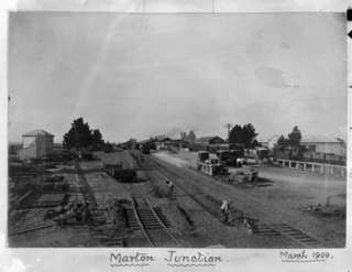
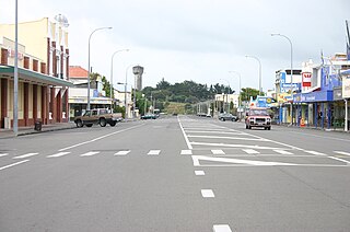
Marton is a town in the Rangitikei district of the Manawatū-Whanganui region of New Zealand's North Island. It is situated 35 kilometres southeast of Whanganui and 40 kilometres northwest of Palmerston North.

<span class="mw-page-title-main">Paraparaumu</span> Town in Wellington, New Zealand

Paraparaumu is a town in the south-western North Island of New Zealand. It lies on the Kapiti Coast, 55 kilometres (34 mi) north of the nation's capital city, Wellington.

Bunnythorpe is a village in the Manawatū-Whanganui region of New Zealand's North Island, 10 km (6 mi) north of the region's major city, Palmerston North. Dairy farms predominate the surrounding area but the community facilities include Bunnythorpe School, with a roll of about 80 pupils as of 2010 as well as a Rugby Football Club, Country Club and several manufacturing plants. The population was 687 in the 2018 census.

<span class="mw-page-title-main">Roslyn, Palmerston North</span> Suburb of Palmerston North in Palmerston North City, Manawatū-Whanganui region, New Zealand

Roslyn is a suburb in the city of Palmerston North, Manawatū-Whanganui, New Zealand.

Te Horo and Te Horo Beach are two localities on the Kapiti Coast of New Zealand's North Island. Te Horo Beach is the larger of the two settlements and, as its name implies, is located on the Tasman Sea coast. Te Horo is located to the east, a short distance inland. They are situated between Peka Peka and Waikanae to the south and Ōtaki to the north. "Te Horo" in the Māori language means "the landslide".

Kelvin Grove is a suburb of Palmerston North on New Zealand's North Island. It is bounded on the north by the North Island Main Trunk railway, Manawatu District and Milson, on the west by Palmerston North–Gisborne Line and Roslyn, the south by the Manawatu River, and the east by James Line and Whakarongo.

Hokowhitu is a riverside suburb of the New Zealand city of Palmerston North, with some of the highest property values in the city.

Aokautere is a suburb of the New Zealand city of Palmerston North. It is situated in the cliffs on the south banks of the Manawatu River.

Turitea is a suburb of Palmerston North in the Manawatū-Whanganui region of New Zealand. It is located on the southern side of the Manawatu River, south of Massey University.

Milson is a suburb of Palmerston North, Manawatū-Whanganui, New Zealand. The suburb is located to the north of the city, beyond the North Island Main Trunk Rail.

<span class="mw-page-title-main">Takaro</span> Suburb of Palmerston North in Manawatū-Whanganui region, New Zealand

Takaro is a suburb and constituent ward of Palmerston North, Manawatū-Whanganui, New Zealand.

<span class="mw-page-title-main">West End, Palmerston North</span> Suburb in Palmerston North, New Zealand

West End is a suburb of the New Zealand city of Palmerston North.

<span class="mw-page-title-main">Palmerston North Central</span> Central business district in Manawatū-Whanganui region, New Zealand

Palmerston North Central is the central suburb and central business district of Palmerston North, on New Zealand's North Island.

<span class="mw-page-title-main">Mangatainoka</span> Place in Manawatū-Whanganui, New Zealand

Mangatainoka is a small settlement in the Tararua District of New Zealand's North Island. It is located on the banks of the Mangatainoka River, 5 km (3.1 mi) north of Pahiatua.

Longburn is a rural settlement just outside Palmerston North in the Manawatū-Whanganui area of New Zealand. Made up of large dairy processing plants Longburn is often mistaken to be a small township and not seen as a large satellite town of Palmerston North. The township is home to both Longburn School and Longburn Adventist College.

Rangiotu is a farming community in the Manawatu District and Manawatū-Whanganui region in New Zealand's central North Island.

References

  1. 1 2 3 4 "Linton". ourregion.co.nz.
  2. "Linton Country School". Linton Country School. Retrieved 14 November 2022.
  3. 1 2 "Statistical area 1 dataset for 2018 Census". Statistics New Zealand. March 2020. Pihauatua (232500). 2018 Census place summary: Pihauatua
  4. "ArcGIS Web Application". statsnz.maps.arcgis.com. Retrieved 27 April 2021.
  5. "Linton Camp School Official School Website". lintoncamp.school.nz.
  6. "Linton Camp School Ministry of Education School Profile". educationcounts.govt.nz. Ministry of Education.
  7. "Linton Camp School Education Review Office Report". ero.govt.nz. Education Review Office.
  8. "Linton Country School Official School Website". lintoncountry.school.nz.
  9. "Linton Country School Ministry of Education School Profile". educationcounts.govt.nz. Ministry of Education.
  10. Heagney, George (15 April 2023). "Troubled Linton Country School shuts its doors". Stuff.

Coordinates: 40°26′S175°33′E / 40.433°S 175.550°E / -40.433; 175.550