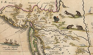
At the time of European settlement, the area was largely the territory of the AcquackanonkRaritan, Tappan, and HackensackNative American tribes. The Munsee lived in the colony's northwestern reaches, the Highlands, while the Wappinger lived to the northeast in the Hudson Valley. The definition of these groups as they are known today is often from the perception of the colonizing Dutch, who tended to call the existing people by the name of a location within their territory, thus creating an exonym. Both the Lenape and Dutch often named a place based on the geography or geology of the natural environment and described a shape, location, feature, quality, or phenomenon.
The Lenape were without a written language. The Swannekins, or Salt Water People (as the Europeans were called),[2] used the Latin alphabet to write down the words they heard from the Wilden (as the Lenape were called).[2] These approximations were no doubt greatly influenced by Dutch, which was the lingua franca of the multilingual province.[3] Some names still exist in their altered form, their current spelling (and presumably pronunciation) having evolved over the last four centuries into AmericanEnglish.
In some cases it cannot be confirmed, or there is contention, as to whether the roots are in the Dutch or the Lenape language, as sources do not always concur. In others, the meaning of the Lenape can have several interpretations. Locative suffixes vary depending on the dialect (usually Munsee or Unami) of the Lenape that prevailed. Jersey Dutch was spoken in the region until the 20th century.
Many rivers in the region bear names based in their Lenape appellation.Map c.1634, Early names for Bergen were Oesters Eylandt (Oyster Island) and Achter Kol. The three structures likely represented Communipaw, Paulus Hook, and Harsimus.
Acquackanonk
Name of an Unami group who lived along and between the banks of the Passaic River Neck.[4] Meaning a place in a rapid stream where fishing is done with a net,[5] alternatively, at the lamprey stream, from contemporary axkwaakahnung. Spellings include Achquakanonk, Acquackanonk,[6]Auchaquackanock,[7]Ackquekenon.[8]Acquackanonk Township was one of the state's first townships, established in 1683. Pieces of it were taken over the years to create the towns of Fairfield, Paterson, Little Falls, Passaic, and Montclair. It ceased to exist with the creation of Clifton in 1917. A bridge in the township was burned as General George Washington's army retreated from Fort Lee in 1776, during the American Revolution.
Achter Kol
Described the area around Newark Bay and the rivers that flowed into it. Called Meghgectecock by the Lenape. Achter, meaning behind, and kol, meaning neck, can be translated as the back (of the) peninsula,[9] in this case Bergen Neck. Variations include Achter Col, Achter Kull, Archer Col, Achter Kull.[10] The name Achter Kol is largely extinct, though it is likely to have evolved into Arthur Kill, the name of a different waterway in the area.[11]
Arresick
A former tidal island, site of first ferry landing for the patroonship Pavonia.
Arresick can be translated as burial ground.[11] It can also be spelled as Arressechhonk.[12]
The island has been absorbed by landfill and is now part of the Paulus Hook neighborhood of Jersey City.
Under Dutch sovereignty the island became the property of Isaack Bedloo, a merchant and "select burgher" of New Amsterdam, and one of 94 signers of the "Remonstrance of the People of New Netherlands to the Director-General and Council".[15] It has been the home of the Statue of Liberty since 1886, and was renamed to Liberty Island in 1956.
Bergen
There are various opinions as to the naming of Bergen. Some say that it so called for Bergen op Zoom in the Netherlands, or for the city of Bergen in Norway.[16] Others believe it comes from the word bergen, which in the Germanic languages of northern Europe means hills,[17] and could have been used to describe a distinct geological feature of the region, The Palisades.[18] Yet another interpretation is that it comes from the Dutch word bergen, meaning to save or to recover, or place of safety, inspired by the settlers returning after they had fled attacks by the native population[19] in the Peach War.
Site of the summer encampment and council fire of the Hackensack tribe, its complete meaning has been lost. Spellings include Gamoenapa,[2]Gemonepan,[23]Gemoenepaen,[23]Gamenepaw, Comounepaw, Comounepan,[12] Communipau,[24] Goneuipan.[25]
Some suggest it is derived from the Lenape words gamunk, meaning on the other side of the river, and pe-auke, meaning water-land or big landing-place.[26] Others have suggested that it might come from the "Community of Pauw", which likely is more a coincidence than a fact.[27][28][29][30]
A land grant to Jacob Jacobsen Roy who was a chief gunner or constable in Fort Amsterdam in New Amsterdam in 1646, by the Dutch West India Company, under the leadership of Director-General William Kieft. Konstapel's Hoeck in Dutch, takes its name from Roy's title.[31] A hoek or hoeck in Dutch meaning a spit of land or small peninsula. Though not used, could be translated to English as Gunner's Point.
Cromakill
Cromakill Creek, likely from kromme kille meaning crooked creek, border between Secaucus and North Bergen. Similar to evolution of Gramercy, which is a corruption of the krom mesje, or little crooked knife, the name of a small brook that flowed along what is now 21st Street in Manhattan.[32]
Kill Van Kull connects Newark Bay with Upper New York Bay
Cresskill
From the watercress that grew in its streams, or kills in the historical Dutch.[33]
The borough of Cresskill exists today in modern Bergen County.
Deep Voll
Diepte Voll, which literally translates to Deep Fall, to describe the brook's numerous waterfalls and steep slopes. Known as Muksukemuk to the Lenape.[34]
The Deep Voll Brook is a tributary of the Goffle Brook in the Passaic River watershed.
Small section of suburban Paramus reputed to be the former site of a "slave community." According to local histories and an historic marker at the site, Dunkerhook was once home to a population of African Americans, many or all of whom were slaves, as well as a "slave school" and "slave church." However, primary historic documentation establishes that Dunkerhook was populated not by slaves, but rather primarily by free African Americans.[36]
The meadowlands, river and city, the Lenape group and their territory, take their name from site of semi-permanent encampment on the neck between the river and Overpeck Creek, near the Teaneck Ridge. Variously translated as place of stony ground[37] or place of sharp ground.[6] Spellings include Ahkingeesahkuy, Achsinnigeu-haki,[37] Achinigeu-hach, Ack-kinkas-hacky, Achkinhenhcky, Ackingsah-sack, Ackinckeshacky,[6]Hackinsack.[2]
Alternatively, suggested as the place where two rivers come together on low ground or stream which discharges itself into another on the level ground,[38] which would speak to the confluence of the Hackensack and Overpeck Creek or Passaic River.
Meaning is not clear, possibly Crow's Marsh. Site of a seasonal Hackensack encampment and one of the first "bouweries" built by Dutch settlers at Pavonia. Spellings include: Aharsimus,[39]Ahasimus,[4][40]Hasymes,[41]Haassemus, Hahassemes, Hasimus, Horseemes, Hasseme,[25]Horsimus[7] Contemporary: ahas meaning crow[42]
Haverstraw
One of the first locales to appear on maps of North America, listed as Haverstroo, which means oat straw.
Tobacco pipe, from hoopookum or hupoken[6] Most likely to refer to the soapstone collected there to carve tobacco pipes, in a phrase that became Hopoghan Hackingh[43] or place of stone for the tobacco pipe. Contemporary: Hopoakan meaning pipe for smoking.
Alternatively from Hoebuck, old Dutch for high bluff and likely referring to Castle Point[44] Variations used during the colonial era included Hobock,[45]Hobocan, Hoboocken,[46] and Hobuck,.[44] Although the spelling Hoboken was used by the English as early as 1668,[12] it doesn't appear that until Col. John Steven purchased the land on which the city is situated that it became common.
Some would believe the city to be named after European town of the same name. The FlemishHoboken, annexed in 1983 to Antwerp, Belgium,[27] is derived from Middle Dutch Hooghe Buechen or Hoge Beuken, meaning High Beeches or Tall Beeches.[47] Established in 1135, the New Netherlanders were likely aware of its existence (and may have pronounced the Lenape to conform a more familiar sound), but it is doubtful that the city on the Hudson is named for it.[48]
Houvenkopf
The mountain's name is from the Dutch Hooge Kop, meaning High Head.
Separating Bayonne and Staten Island. From the Middle Dutch word kille, meaning riverbed or water channel. Likely evolved from Achter Col, as in kille van kol, or channel from the neck, its spellings including Kill von Cull, Kille van Cole, Kill van Koll.
Kinderkamack
This distinctly Dutch-sounding name which describes the area along middle reaches of Hackensack River, is said to come from the Lenape and mean place of ceremonial dance and worship.[49]
Losen Slote
A tributary of the Hackensack River,[50] from losen and sloot, or a dumping trench, essentially an open sewer.
Mahwah
Mawewi meaning meeting place or place where paths meet or assembly[6] Contemporary: mawemin.[51]
Manhattan
From Manna-hata, as written in the 1609 logbook of Robert Juet, an officer on Henry Hudson's yacht Halve Maen (Half Moon).[52] A 1610 map depicts the name Manahata twice, on both the west and east sides of the Mauritius River (later named the Hudson River). The word "Manhattan" has been translated as the island of many hills .[53]The Encyclopedia of New York City offers other derivations, including from the Munsee dialect of Lenape: manahachtanienk ("place of general inebriation"), manahatouh ("place where timber is procured for bows and arrows"), or menatay ("island").[54]
Meghgectecock
This is perhaps an approximation of masgichteu-cunk meaning where May-apples grow, from a moist-woodland perennial that bears edible yellow berries[18] and used to describe the lobe of land between and the confluence of the Hackensack and Passaic Rivers at Newark Bay.[12] It was part of Achter Col for the New Netherlanders and New Barbadoes Neck to the British. Contemporary: masgichteu meaning may apple.[6]
Minkakwa
On Bergen Neck between Pamrapo and Communipaw at Caven Point,.[25] first settled by New Netherlanders in 1647. Spellings include Minelque and Minkacque meaning a place of good crossing probably because it was the most convenient pass between the two bays on either side of the neck, (or could mean place where the coves meet; in this case where they are closest to each other and, hence advantageous for portage.)
Called Muhheakantuck or the river that flowed two ways in Unami. The Noort Rivier was one of the three main rivers in New Netherland,[56] the others being the Versche Rivier or Fresh River (likely because of its sweet water) and the Zuid Rivier or South River. In maritime usage, it still defines that part of the Hudson between Hudson County and Manhattan.[57] Another story of its origin has it that the rivers connected to New York Harbor are named the "North" River and "East" River based on what direction of travel they permit.[58]
Outwater
Possibly uiterwaarden meaning a flood plain, of which there were many, this one at the foot of Paterson Plank Road. More likely from a landowner in the area.[59][60]
Oever meaning a sloping bank and perk meaning border or boundary, hence at the water's edge,[61] actually a riparian zone. Used in English as early as 1665. By the Lenape called Tantaqua, it was the site of semi-permanent village of the Hackensack.
Pequannock
From Paquettahhnuake meaning cleared land ready or being readied for cultivation.[62]Packanack is also contemporary variation of this place and the people Pacquanacs.
From Parampseapus or Peremessing meaning, perhaps, where there is worthwhile (or fertile) land or place of wild turkeys.[63]Seapus or sipus is said to mean water, so the name may mean turkey river. Saddle River was also called Peramseapus. Spellings include Pyramus.[64][65]
The county, river and city are taken from pahsayèk,[66]pahsaayeek[6] and pasayak, meaning valley or water that flows through the valley. Spellings include: Pawsaick, Pissawack. Contemporary: Pachsa'jeek.[6]
Pavonia, the first settlement by the Europeans took its name from a burgermeester of Amsterdam. Also an investor in Dutch West India Company (WIC), Michiel Reyniersz Pauw, purchased land along the banks of the Hudson in 1630 in order to establish a patroonship. Pavonia is a Latinized version of his surname, based on the word for peacock. The bouweries, plantages, and port that made up the settlement grew into the gemeente of Bergen.
Polifly
From Dutch pole and vlaie, translated as "top of the meadow/atop the swamp"; the name by which the area of Hasbrouck Heights was known.[67] Polifly Road is a major thoroughfare connecting Hackensack and Hasbrouck Heights.
Pompton
Has been cited by some sources to mean a place where they catch soft fish.[68]
A tidal island, called Arresick by the Lenape the site where, in 1630, Michiel Reyniersz Pauw staked a claim for his attempted patroonship, Pavonia. Named after his agent, Michael Paulez (later latinized to Paulus) who built a hut and ferry landing there, hoek or hoeck meaning a spit or point. Variations include Paulus Hoeck, Powles Hoek, Powles Hook.
Preakness
From the munsi, quail woods.[69] Alternatively, thought to mean young buck, depending on interpretation of the original word.[70][71]
Ramapo
Name for the mountains and river and towns, meaning underneath the rock, spellings: Ramapough, Ramopock.
Raritan
The people, river, bay, and towns take their name from a derivation of Naraticong meaning river beyond the island (which, considering location, could be Staten Island). Some would believe that it comes from Roaton or Raritanghe, a tribe which had come from across the Hudson River and displaced the existing population of Sanhicans.[18][72]
Alternatively, Raritan is a Dutch pronunciation of wawitan or rarachons meaning forked river or stream overflows.[73]
Sukit meaning black and achgook meaning snake,[75] hence black snakes.[38] Spellings include Sekakes,[29]Sikakes, Sickakus. Contemporary: seke meaning black and xkuk or achgook[76] meaning snake.[77] Locally, pronounced "SEE-kaw-cus", with the accent on the first syllable, not the second as often used by non-natives.[78]Snake Hill, in Secaucus, is a geologic intrusion in the midst of the Meadowlands.
Sicomac
Said to mean resting place for the departed or happy hunting ground since this area of Wyckoff, according to tradition, was the burial place of many Native Americans, possibly including Oratam, sagamore of the Hackensack Indians.[79] Contemporary schikamik meaning hole or grave or machtschikamikunk meaning a burial place.[80]
Staaten Eylandt
To the Lenape, the island was known as Aquehonga, Manacknong and Eghquaons (Jackson, 1995). Named by colonists for the governing body of the 17th century United Provinces of the Netherlands, The States-General.
Tantaqua
Overpeck Creek, site of Hackensack semi-permanent village, for one of the chiefs of the resident Lenape.[12]
Likely more related to contemporary petapan meaning dawn or petapaniui meaning at the break of dawn,[80] and relates to their kin across the river, the Wappinger,, whose name is derived from the Algonquian people of the east or easterners. (Contemporary: Wapaneu meaning easterly and Wapanke meaning to-morrow.)
Teaneck
Origin and meaning are uncertain, though possibly may mean the woods.[83][84] An alternative is from the Dutch "Tiene Neck" meaning "neck where there are willows" (from the Dutch "tene" meaning willow).
Tenafly
From Dutch ten and vlaie, hence Tiene Vly or Ten Swamps given by settlers in 1688.[85]
Watchung
The place of mountains from watchtsu,[86] which describes the three ridges west of the Meadowlands.
Variously interpreted as or rocks that look like rows of trees or at the end of (the Palisades or stream that flowed from them.) and place of gulls.[87]
Spelling have included: Awiehawken, Wiehacken, Weehauk, Weehawk, Weehock, Wiceaken, Wihaken, Wyhaken, and Wiehachan.
Curiously, Peter Minuit, first governor of New Netherland, sailed to the New World upon a ship called the "Seagull", or in Dutch, Het "Meeuwken" (which bears a striking resemblance).
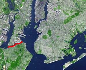
The Kill Van Kull is a tidal strait between Staten Island, New York and Bayonne, New Jersey in the United States. It is approximately 3 miles (4.8 km) long and 1,000 feet (305 m) wide and connects Newark Bay with Upper New York Bay. The Robbins Reef Light is at the eastern end of the Kill, and Bergen Point marks its western end. It is spanned by the Bayonne Bridge and is one of the most heavily traveled waterways in the Port of New York and New Jersey.
The Hackensack River is a river, approximately 45 miles (72 km) long, in the U.S. states of New York and New Jersey, emptying into Newark Bay, a back chamber of New York Harbor. The watershed of the river includes part of the suburban area outside New York City just west of the lower Hudson River, which it roughly parallels, separated from it by the New Jersey Palisades. It also flows through and drains the New Jersey Meadowlands. The lower river, which is navigable as far as the city of Hackensack, is heavily industrialized and forms a commercial extension of Newark Bay.
Acquackanonk Township was a township that existed in New Jersey, United States, from 1693 until 1917, first in Essex County and then in Passaic County.
New Barbadoes Township was a township that was formed in 1710 and existed in its largest extent prior to the American Revolutionary War in Bergen County, New Jersey. The Township was created from territories that had been part of Essex County that were transferred by royal decree to Bergen County. After many departures, secessions and deannexations over the centuries, New Barbadoes Township exists presently as Hackensack, which adopted its present name in 1921.
Bergen Township was a township that existed in the U.S. state of New Jersey, from 1661 to 1862, first as Bergen, New Netherland, then as part Bergen County, and later as part of Hudson County. Several places still bear the name: the township of North Bergen; Bergen Square, Old Bergen Road, Bergen Avenue, Bergen Junction, Bergen Hill and Bergen Arches in Jersey City; Bergen Point in Bayonne; and Bergenline Avenue and Bergen Turnpike in North Hudson.
Bergen Hill refers to the lower Hudson Palisades in New Jersey, where they emerge on Bergen Neck, which in turn is the peninsula between the Hackensack and Hudson Rivers, and their bays. In Hudson County, it reaches a height of 260 feet.
Pavonia was the first European settlement on the west bank of the North River that was part of the seventeenth-century province of New Netherland in what would become the present Hudson County, New Jersey.
New Barbadoes Neck is the name given in the colonial era for the peninsula in northeastern New Jersey, US between the lower Hackensack and Passaic Rivers, in what is now western Hudson County and southern Bergen County. The neck begins in the south at Kearny Point in the Newark Bay and is characterized by a ridge along the west and part of the New Jersey Meadowlands on the east.
Vriessendael was a patroonship on the west bank of the Hudson River in New Netherland, the seventeenth century North American colonial province of the Dutch Empire. The homestead or plantation was located on a tract of about 500 acres (2.0 km2) about an hour's walk north of Communipaw at today's Edgewater. It has also been known as Tappan, which referred to the wider region of the New Jersey Palisades, rising above the river on both sides of the New York/New Jersey state line, and to the indigenous people who lived there and were part of wider group known as Lenape. It was established in 1640 by David Pietersen de Vries, a Dutch sea captain, explorer, and trader who had also established settlements at the Zwaanendael Colony and on Staten Island. The name can roughly be translated as De Vries' Valley. De Vries also owned flatlands along the Hackensack River, in the area named by the Dutch settlers Achter Col. Parts of Vriessendael were destroyed in 1643 in reprisal for the slaughter of Tappan and Wecquaesgeek Native Americans who had taken refuge at Pavonia and Corlears Hook. The patroon's relatively good relations with the Lenape prevented the murder of the plantation's residents, who were able to seek sanctuary in the main house, and later flee to New Amsterdam. The incident was one of the first of many to take place during Kieft's War, a series of often bloody conflicts with bands of Lenape, who had united in face of attacks ordered by the Director of New Netherland.
Achter Kol was the name given to the region around the Newark Bay and Hackensack River in northeastern New Jersey by the first European settlers to it and was part of the 17th century province of New Netherland, administered by the Dutch West India Company. At the time of their arrival, the area was inhabited by the Hackensack and Raritan groups of Lenape natives.
Bergen was a part of the 17th century province of New Netherland, in the area in northeastern New Jersey along the Hudson and Hackensack Rivers that would become contemporary Hudson and Bergen Counties. Though it only officially existed as an independent municipality from 1661, with the founding of a village at Bergen Square, Bergen began as a factory at Communipaw circa 1615 and was first settled in 1630 as Pavonia. These early settlements were along the banks of the North River across from New Amsterdam, under whose jurisdiction they fell.
Oratam was sagamore, or sachem, of the Hackensack Indians living in northeastern New Jersey during the period of early European colonization in the 17th century. Documentation shows that he lived an unusually long life and was quite influential among indigenous and immigrant populations.
Hackensack was the exonym given by the Dutch colonists to a band of the Lenape, or Lenni-Lenape, a Native American tribe. The name is a Dutch derivation of the Lenape word for what is now the region of northeastern New Jersey along the Hudson and Hackensack rivers. While the Lenape people occupied much of the mid-Atlantic area, Europeans referred to small groups of native people by the names associated with the places where they lived.
The Acquackanonk were a Lenape group whose territory was on the Passaic River in northern New Jersey. They spoke the same dialect (Unami) and shared the same totem (turtle) as the neighboring Hackensack, Tappan and Rumachenanck . It may mean a place in a rapid stream where fishing is done with a net. Alternatively, at the lamprey stream from contemporary axkwaakahnung Lastly it may mean where gum blocks were made for pounding corn. Ackquekenon was spelling used by European explorer Jasper Danckaerts in 1679.
Harsimus is a neighborhood within Downtown Jersey City, Hudson County, in the U.S. state of New Jersey. The neighborhood stretches from the Harsimus Stem Embankment on the north to Christopher Columbus Drive on the south between Coles Street and Grove Street or more broadly, to Marin Boulevard. It borders the neighborhoods of Hamilton Park to the north, Van Vorst Park to the south, the Village to the west, and the Powerhouse Arts District to the east. Newark Avenue has traditionally been its main street. The name is from the Lenape, used by the Hackensack Indians who inhabited the region and could be translated as Crow's Marsh. From many years, the neighborhood was part of the "Horseshoe", a political delineation created by its position between the converging rail lines and political gerrymandering.
Curries Woods is a neighborhood in the southern part of Greenville in Jersey City, New Jersey bordering Bayonne. It was named after James Curie, who was on the town Committee for Greenville when it was its own Township in the 19th century. The area remained rural until the later part of the century when the Central Railroad of New Jersey built a line connecting ferries to Elizabeth, New Jersey and New York City. Currie's Woods still remained untouched through the late part of the century and it was valued for its woods, rocky shore and dunes on Newark Bay. A lot of the land was eventually lost, but a tract was set aside in the early part of the 20th century. A small cemetery, the Old Greenville Cemetery, was nearby. This park lost much of its land to the city's largest Housing Authority project in 1959, except a small tract in Bayonne, Mercer Park.
West Hudson is the western part of Hudson County, New Jersey comprising the contiguous municipalities of Kearny, Harrison and East Newark, which lies on the peninsula between the Hackensack River and Passaic River.
The English Neighborhood was the colonial-era name for the towns in eastern Bergen County, New Jersey, along the Hudson Palisades between the Hudson River and the Hackensack River, particularly around its main tributary, Overpeck Creek. The region had been part of the Dutch New Netherland colony of Bergen, whose main town was located at Bergen Square in modern Jersey City. The name refers to the geography of the region, bergen being the Dutch word for hills. Earlier attempts at settlement at Achter Col and Vriessendael had been compromised in conflicts with the precolonial population, bands of the Lenape known by their exonyms, the Hackensacks and the Tappans.
1 2 On July 12th, 1630, Mr. Michael Pauw, Burgomaster of Amsterdam and Lord of Achtienhover, near Utrecht, obtained through the Directors and Councillors of New Netherlands, a deed from the Indians to the land called Hopoghan Hackingh, this being the first deed recorded in New Netherlands. On November 22nd, of the same year, the same parties procured from the Indians a deed to Mr. Pauw of Ahasimus and Aresick (burying-ground), the peninsula later called Paulus Hook.
1 2 3 4 5 New Jersey Colonial Records, East Jersey Records: Part 1-Volume 21, Calendar of Records 1664-1702
↑ Clayton, W.W.; William Nelson (1882). History of Bergen and Passaic counties, New Jersey, with biographical sketches of many of its pioneers and prominent men. Philadelphia: Everts and Peck. p.18.
↑ Grundy, J. Owen (1975). "A Dutch Legacy". The History of Jersey City (1609 - 1976). Jersey City: Walter E. Knight; Progress Printing Company. p.5.
↑ Ferretti, Fred (10 June 1979), "Jersey City Hopes to Save Caven Point", New York Times
↑ Shorto, Russell (2004). The Island at the Center of the World: The Epic Story of Dutch Manhattan and the Forgotten Colony that Shaped America. Random House. ISBN1-4000-7867-9.
↑ Winfield, Charles (1874). History of the County of Hudson, New Jersey: From its Earliest Settlement to the Present Time. New York: Kennaud & Hay Stationary M'fg and Printing Company. p.51.
1 2 Joan F. Doherty, Hudson County The Left Bank, ISBN0-89781-172-0 (Windsor Publications, Inc., 1986)
1 2 Gannett, Ganett, Henry, The Origin of Certain Place Names in The United States
↑ Writers' Program (U.S.) New Jersey. The Origin of New Jersey Place Names Trenton, NJ, New Jersey Public Library Commission, 1945. ... www.njstatelib.org/NJ_Information/Digital_Collections/Digidox7.php
↑ Joan F. Doherty, Hudson County The Left Bank, ISBN0-89781-172-0 (Windsor Publications, Inc., 1986)
↑ Reply, 27 July 2011 at 4:37 pm Hieronymo Wild Turkeys! This makes me like Paramus more… (21 July 2011). "paramus, or land of the wild turkey". Retrieved 18 June 2016.{{cite web}}: CS1 maint: numeric names: authors list (link)
↑ Nelson, William. The Indians of New Jersey: Their Origin and Development; Manners and Customs; Language, Religion, and Government. The Press Printing and Publishing Company, Paterson, NJ, 1894. See Page 127. Available via Google Books
↑ The Origin of New Jersey Place Names. Federal Writer’s Program of the Work Progress Administration of New Jersey. Reissued by the New Jersey Public Library Commission, State House Annex, Trenton, NJ, 1945. Available Online
↑ Between 1628 and 1640, the Sanhicans were driven away from the west shore of Raritan Bay by a band of Wisquaskecks, known as the Roaton or Raritanghe, who removed from their territory north of Manhattan across Staten Island and into the lower Raritan Valley.
↑ Troeger, Virginia, B. and McEwen, Rbert, James Woodbridge, 2002, Charleston, SC: Arcadia Publishing, p18
↑ "The Manhattan". John W. Orr. 1 January 1883. Retrieved 18 June 2016– via Google Books.
↑ Anthony, Rev A.S and Binton D.G. (editors) Lenape-English Dictionary, 1888, (Historical Society of Penn)
↑ Old Tappan Tappan is the name given to the region and its inhabitants by New Netherlanders from the 1687 patent: "…a Cartaine trackt of Landt named ould tappan as ye same is bounded by trees marked by ye indians." Tappan, from the Lenni Lenape word Tuphanne (reputed to mean cold water)
Lucas Litchenberg, De Nieuwe Wereld van Peter Stuyvesant: Nederlandse voetsporen in de Verenigde Staten, ISBN90-5018-426-X, NUGI 470, Uitgeverij Balans, 1999
↑ Beck, Henry Charleton, Tales and Towns of Northern New Jersey, Rutgers University Press, ISBN978-0-8135-1019-4
This page is based on this Wikipedia article Text is available under the CC BY-SA 4.0 license; additional terms may apply. Images, videos and audio are available under their respective licenses.