
Germantown is an area in Northwest Philadelphia, Pennsylvania. Founded by Palatine, Quaker, and Mennonite families in 1683 as an independent borough, it was absorbed into Philadelphia in 1854. The area, which is about six miles northwest from the city center, now consists of two neighborhoods: 'Germantown' and 'East Germantown'.
Frankford is a neighborhood in the Northeast section of Philadelphia situated about six miles (10 km) northeast of Center City. Although its borders are vaguely defined, the neighborhood is bounded roughly by the original course of Frankford Creek on the south to Castor Avenue on the northwest and southwest, to Cheltenham Avenue on the north, and to Aramingo Avenue and I-95 on the east. Adjacent neighborhoods are Bridesburg, Juniata, Northwood, Summerdale, and Wissinoming.
Holmesburg began as a Village within Lower Dublin Township, Pennsylvania. It is now a neighborhood in the Northeast section of Philadelphia, Pennsylvania, United States. Holmesburg was named in Honor of Surveyor General of Pennsylvania Thomas Holme, who was a cartographer.

Center City includes the central business district and central neighborhoods of Philadelphia, Pennsylvania, United States. It comprises the area that made up the City of Philadelphia prior to the Act of Consolidation, 1854, which extended the city borders to be coterminous with Philadelphia County.

West Kensington is a neighborhood in the North Philadelphia section of Philadelphia, Pennsylvania, United States. It is north of Olde Kensington. The Market Frankford El above Front Street forms the line between West Kensington and Kensington. Its bordering neighborhoods are Kensington to the east, Hartranft to the west, and Olde Kensington to the south. It is bounded by Front Street to the east, 6th Street to the west, Cecil B. Moore Avenue to the South and Lehigh Avenue to the north. It falls into the 19122 and 19133 ZIP Codes.

East Falls is a neighborhood in Lower Northwest, Philadelphia, Pennsylvania, United States. It lies on the east bank of the "Falls of the Schuylkill," cataracts submerged in 1822 by the Schuylkill Canal and Fairmount Water Works projects. East Falls sits next to the Germantown, Roxborough, Allegheny West, and the Nicetown-Tioga neighborhoods. Wissahickon Valley Park separates it from Manayunk, Philadelphia.

Wayne Junction station is a SEPTA Regional Rail junction station located at 4481 Wayne Avenue, extending along Windrim Avenue to Germantown Avenue. The station is located in the Nicetown neighborhood of Philadelphia. Wayne Junction serves as a multi-modal transfer point between six of SEPTA's regional rail lines as well as three major transit routes – the Route 75 Trackless Trolley and the Route 23 and 53 bus lines. The station served more than 321,000 riders annually in 2018.
Logan is a neighborhood in the upper North Philadelphia section of the city of Philadelphia, in the U.S. state of Pennsylvania. The majority of the neighborhood falls within the 19141 zip code, but some of it falls within 19140. The neighborhood is sometimes confused with the Olney neighborhood of Philadelphia. Olney Avenue extends from both the Olney and Logan neighborhoods of the city. The Olney Transportation Center is located in Logan.

Tacony is a historic neighborhood in Northeast Philadelphia, United States, approximately 8 miles (13 km) from downtown Philadelphia. It is bounded by the east side of Frankford Avenue on the northwest, the south side of Cottman Avenue on the northeast, the north side of Robbins Street on the southwest, and the Delaware River and Interstate 95 on the southeast.

Hartranft is a neighborhood in the central part of North Philadelphia section of Philadelphia, Pennsylvania.
Fairhill is a neighborhood on the east side of the North Philadelphia section of Philadelphia, Pennsylvania, United States. Fairhill is bordered by Front Street to the east, Germantown Avenue to the west, Allegheny Avenue to the north, and Cumberland Street to the south. The neighborhood serves as the center of the Hispanic community of Philadelphia, and is known for its "El Centro de Oro" commercial strip along North 5th Street. Fairhill is adjacent to Harrowgate and West Kensington to the east, Hartranft to the south, Glenwood to the west, and Hunting Park to the north.

The Connecting Railway was a subsidiary of the Pennsylvania Railroad, incorporated to build a connection between the Philadelphia and Trenton Railroad and the PRR in the city of Philadelphia.
The Colonial Germantown Historic District is a designated National Historic Landmark District in the Germantown and Mount Airy neighborhoods of Philadelphia, Pennsylvania along both sides of Germantown Avenue. This road followed a Native American path from the Delaware River just north of Old City Philadelphia, through Germantown, about 6 miles northwest of Center City Philadelphia, and on to Pottstown. Settlement in the Germantown area began, at the invitation of William Penn, in 1683 by Nederlanders and Germans under the leadership of Francis Daniel Pastorius fleeing religious persecution.

The Frankford Avenue Bridge, also known as the Pennypack Creek Bridge, the Pennypack Bridge, the Holmesburg Bridge, and the King's Highway Bridge, erected in 1697 in the Holmesburg section of Northeast Philadelphia, in the U.S. state of Pennsylvania, is the oldest surviving roadway bridge in the United States. The three-span, 73-foot-long (22 m) twin stone arch bridge carries Frankford Avenue, just north of Solly Avenue, over Pennypack Creek in Pennypack Park.

Nicetown–Tioga is a neighborhood in the North Philadelphia section of the city of Philadelphia, in the U.S. state of Pennsylvania. It comprises two smaller, older neighborhoods, Nicetown and Tioga, although the distinction between the two is rarely emphasized today. The name "Nicetown" is often simply used to refer to any part of Nicetown–Tioga.

Glenwood is a neighborhood in North Philadelphia, Pennsylvania, United States. It is located in the vicinity of North Philadelphia Station to West York Street.

The Hatfield House is an historic house which is located in Fairmount Park in Philadelphia, Pennsylvania.
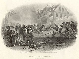
Germantown Pike is a historic road in Pennsylvania that opened in 1687, running from Philadelphia northwest to Collegeville. The road is particularly notable for the "imposing mansions" that existed in the Germantown neighborhood in Philadelphia. The road was left in ruins after the British destroyed it in the Revolutionary War during the 1777 Battle of Germantown, and was not rebuilt until 1809. Portions of Germantown Pike were signed as U.S. Route 422 (US 422) before the latter was rerouted along a freeway alignment to King of Prussia.


