List of Indian Air Force stations

Last updated

The Indian Air Force currently operates seven Air Commands. Each command is headed by an Air Officer Commanding-in-Chief of the rank of Air Marshal.

Contents

The Air Force currently has over 60 air stations all over India. These are grouped into seven commands: Western Air Command at New Delhi, Delhi. Eastern Air Command at Shillong, Meghalaya. Central Air Command at Prayagraj, Uttar Pradesh. Southern Air Command at Thiruvananthapuram, Kerala. South Western Air Command at Gandhinagar, Gujarat. Training Command at Bengaluru, Karnataka, and Maintenance Command at Nagpur, Maharashtra. The largest airbase is in Hindon, Uttar Pradesh.

There are a number of newer air stations being built as well, in line with India's strategic doctrine. The Indian Navy has some separate air stations for its aviation wing.

Western Air Command is the largest Air Command. It operates sixteen air stations from Jammu & Kashmir, Punjab, Haryana, Himachal Pradesh and a couple of Air stations in Uttar Pradesh. Eastern Air Command operates fifteen air stations in eastern and north-eastern India. Central Air Command operates two air stations in Uttar Pradesh, Madhya Pradesh and surrounding states of central India. Southern Air Command's tasks include protecting the vital shipping routes. It operates nine air stations in Southern India and two in the Andaman and Nicobar Islands. South Western Air Command is the front line of defence against Pakistan. This important command operates twelve air stations in Gujarat, Maharashtra and Rajasthan.

List of air stations

List of Indian Air Force stations
Map of this section's coordinates

Note: Station and unit details are from Scramble.nl (2009) and outdated. [1] Article needs to be revised/updated.

Station ICAO Runway Elevation Geographical coordinates State/territory WingSquadronsAircraft
Western Air Command
Adampur AFS VIAX13/31775 ft / 236 m 31°26′06″N75°45′26″E / 31.434879°N 75.757256°E / 31.434879; 75.757256 (Adampur AFS) Punjab 8th Wing No. 47 Squadron

No. 223 Squadron IAF

Mikoyan MiG-29
Ambala AFS VIAM12L/30R
12R/30L
900 ft / 274 m 30°22′14″N76°49′4″E / 30.37056°N 76.81778°E / 30.37056; 76.81778 (Ambala AFS) Haryana 7 Wing No. 5 Squadron

No. 14 Squadron

No. 17 Squadron

14 Sqn Missile and UAV Squadron

2209 & Squadron 2251S

SEPECAT Jaguar

Dassault Rafale

Amritsar AFS VIAR16/34755 ft / 230 m 31°42′28″N74°47′57″E / 31.70778°N 74.79917°E / 31.70778; 74.79917 (Amritsar AFS) Punjab1 FBSU--
Awantipur AFS VIAW12/305,400 ft / 1,646 m 33°52′35.86″N74°58′32.45″E / 33.8766278°N 74.9756806°E / 33.8766278; 74.9756806 (Awantipur AFS) Jammu & Kashmir 8 FBSU--
Bathinda AFS VIBT13/31700 ft /213 m 30°16′08″N74°45′27″E / 30.268848°N 74.757430°E / 30.268848; 74.757430 (Bhatinda AFS) Punjab34 Wing No. 17 Squadron Dassault Rafale
Chandigarh AFS VICG11/291,012 ft / 308 m 30°40′35″N76°47′19″E / 30.676290°N 76.788535°E / 30.676290; 76.788535 (Chandigarh AFS) Chandigarh 12 Wing No. 44 Squadron

No. 48 Squadrons

No. 126 Helicopter Flight

Transport:

Antonov An-32 Ilyushin Il-76

Helicopters:

Mil Mi-26

Boeing CH-47 Chinook

Gurugram AFS [2] [3] [4] Logistics base 28°26′14″N77°01′43″E / 28.437098°N 77.028544°E / 28.437098; 77.028544 (Gurugram AFS) Haryana IFC and IMAC. [5] [6] --
Faridabad AFS Logistics base 28°22′19″N77°16′35″E / 28.371888°N 77.276432°E / 28.371888; 77.276432 (Faridabad AFS) Haryana54 ASP, 56th Air Storage Park, Guard dog training. [7] [8] [9] [10] --
Halwara AFS VIHX13/31790 ft / 241 m 30°44′53″N75°38′00″E / 30.748041°N 75.633209°E / 30.748041; 75.633209 (Halwara AFS) Punjab9 Wing, No. 220 Squadron IAF

No. 221 Squadron IAF

Sukhoi Su-30MKI
Hindon AFS VIDX09/27700 ft / 213 m 28°42′28″N77°21′34″E / 28.707647°N 77.359340°E / 28.707647; 77.359340 (Hindon AFS) Uttar Pradesh 28 Wing No. 77 Squadron

No. 131 Helicopter Flight

No. 181 Flight

No. 129 Helicopter Unit

Transport:

C130J Super Hurcules

Hawker Siddeley HS 748

Boeing 737-200

Helicopters:

HAL Cheetah

Mil Mi-17

Vadsar AFS AFS-- 23°08′46″N72°28′53″E / 23.146200°N 72.481270°E / 23.146200; 72.481270 (Vadsar AFS) Gujarat 47 Signal Unit--
Jammu AFS VIJU18/361029 ft /

314 m

32°41′21″N 074°50′15″EJammu & Kashmir23 Wing No. 153 Helicopter Unit

No. 154 Helicopter Unit

No. 132 Helicopter Flight

No. 223 Squadron IAF

Helicopters:

Mil Mi-17

HAL Cheetah

Combat Jets:

Mikoyan MiG-29

Leh AFS VILH06/24
07R/25L
07L/25R
10,682 ft/ 3,256 m 34°08′14″N77°32′48″E / 34.137216°N 77.546614°E / 34.137216; 77.546614 (Leh AFS) Ladakh 21 Wing No. 114 Helicopter Unit

No. 130 Helicopter Unit

Mil Mi-17

HAL Cheetah

Palam AFS VIDP09/27
10/28
776 ft / 237 m 28°34′25″N77°06′53″E / 28.573736°N 77.114610°E / 28.573736; 77.114610 (Palam AFS) Delhi 3 Wing No. 41 Squadron Hawker Siddeley HS 748

Dornier 228

Pathankot AFS VIPK01/191,017 ft / 310 m 32°14′13″N75°38′00″E / 32.236929°N 75.633227°E / 32.236929; 75.633227 (Pathankot AFS) Punjab18 Wing No. 125 Helicopter Squadron Helicopters:

AH-64 Apache

Sarsawa AFS VISP09/27891 ft / 272 m 29°59′37″N77°25′50″E / 29.993718°N 77.430671°E / 29.993718; 77.430671 (Sarsawa AFS) Uttar Pradesh30 Wing No. 117 Helicopter Unit

No. 152 Helicopter Unit

Mil Mi-17

HAL Dhruv

Sirsa AFS VISX05/23650 ft / 198 m 29°33′46″N75°00′19″E / 29.56278°N 75.00528°E / 29.56278; 75.00528 (Sirsa AFS) Haryana 45 Wing
Srinagar AFS VISR13/315,458 ft / 1,664 m 33°59′40″N74°45′55″E / 33.994374°N 74.765299°E / 33.994374; 74.765299 (Srinagar AFS) Jammu & Kashmir1 Wing No. 223 Squadron Mikoyan MiG-29
Udhampur AFS VIUX18/361,950 ft / 594 m 32°54′41″N75°09′16″E / 32.911503°N 75.154410°E / 32.911503; 75.154410 (Udhampur AFS) Jammu & KashmirHQ AOC J&K

39 Wing

No. 132 Helicopter Flight

No. 152 HU

HAL Cheetah

Mil Mi-17

Eastern Air Command
Purnea AFS VEBD18/36412 ft / 125 m25°45′35″N 087°24′36″E Bihar 14FBSU--
Bagdogra AFS VEBD18/36412 ft / 125 m 26°40′52″N88°19′43″E / 26.68111°N 88.32861°E / 26.68111; 88.32861 (Bagdogra AFS) West Bengal 20 Wing No. 156 Helicopter Unit Mil Mi-17
Barapani AFS VEBI04/222910 ft / 886 m 25°42′13″N091°58′43″E / 25.70361°N 91.97861°E / 25.70361; 91.97861 (Barapani AFS) Meghalaya
Barrackpore AFS VEBR02/2018 ft / 5 m 22°46′55″N88°21′33″E / 22.78194°N 88.35917°E / 22.78194; 88.35917 (Barrackpore AFS) West Bengal6 Wing No. 157 Helicopter Unit Mil Mi-17
Chabua AFS VECA05/23350 ft / 107 m 27°27′44″N95°07′05″E / 27.46222°N 95.11806°E / 27.46222; 95.11806 (Chabua AFS) Assam 14 Wing No. 102 Squadron Sukhoi Su-30MKI
Hasimara AFS VEHX11L/29R
11R/29L
340 ft /104 m 26°41′53″N89°22′08″E / 26.69806°N 89.36889°E / 26.69806; 89.36889 (Hasimara AFS) West Bengal16 WingNo. 101 Squadron IAF Dassault Rafale
Jorhat AFS VEJT04/22284 ft / 87 m 26°43′54″N94°10′32″E / 26.73167°N 94.17556°E / 26.73167; 94.17556 (Jorhat AFS) Assam10 Wing No. 43 Squadron

No. 49 Squadron

Antonov An-32
Kalaikunda AFS VEDX17/35200 ft / 60 m 22°20′21.90″N87°12′52.37″E / 22.3394167°N 87.2145472°E / 22.3394167; 87.2145472 (Kalaikunda AFS) West Bengal5th Wing(Sqdn18 with MiG27s & OCU with MiG21s)
Kumbhigram AFS VEKU06/24352 ft / 107 m 24°54′47″N92°58′43″E / 24.91306°N 92.97861°E / 24.91306; 92.97861 (Kumbhigram AFS) Assam22 Wing No. 110 Helicopter Unit Mil Mi-8
Mohanbari AFS VEMN05/23361 ft / 110 m 27°28′50″N95°01′18″E / 27.48056°N 95.02167°E / 27.48056; 95.02167 (Mohanbari AFS) Assam42 Wing No. 127 Helicopter Unit

No. 128 Helicopter Unit

Mil Mi-17
Mountain Shadow AFS VEGT05/23350 ft / 107 m 26°06′22″N91°35′09″E / 26.10611°N 91.58583°E / 26.10611; 91.58583 (Mountain Shadow AFS) Assam
Panagarh AFS VEPH15/33240 ft / 73 m 23°28′28″N87°25′39″E / 23.47444°N 87.42750°E / 23.47444; 87.42750 (Panagarh AFS) West Bengal62 SU, 87 Squadron No. 87 Squadron C-130J Super Hercules
Tawang AFS VETW8,756 ft / 2,669 m 27°35′19″N91°52′40″E / 27.58861°N 91.87778°E / 27.58861; 91.87778 (Tawang AFS) Arunachal Pradesh
Tezpur AFS VETZ04/22240 ft / 73 m 26°42′44″N92°47′14″E / 26.71222°N 92.78722°E / 26.71222; 92.78722 (Tezpur AFS) Assam11 Wing No. 2 Squadron

No. 106 Squadron

Sukhoi Su-30MKI
Central Air Command
Agra AFS VIAG05/23
12/30
551 ft 167 m 27°09′27″N77°57′39″E / 27.15750°N 77.96083°E / 27.15750; 77.96083 (Agra AFS) Uttar Pradesh4 Wing No. 12 Squadron

No. 78 Squadron No. 50 Squadron

Transport:

Antonov An-32

Ilyushin Il-78

AEW&C:

Beriev A-50

Bakshi Ka Talab AFS VIBL09/27385 ft/ 117 m 26°59′19″N80°53′29″E / 26.98861°N 80.89139°E / 26.98861; 80.89139 (Bakshi Ka Talab AFS) Uttar PradeshAD Flight
Bamrauli AFS VEAB06/24
12/30
322 ft/ 98 m 25°26′24″N81°44′02″E / 25.44000°N 81.73389°E / 25.44000; 81.73389 (Bamrauli AFS) Uttar Pradesh29 Wing
Bareilly AFS VIBY11/29565 ft/ 172 m 28°25′21″N79°26′49″E / 28.42250°N 79.44694°E / 28.42250; 79.44694 (Bareilly AFS) Uttar Pradesh15 Wing No. 111 Helicopter Unit

No. 24 Squadron No. 8 Squadron

Helicopters:

HAL Dhruv

Combat Jets:

Sukhoi Su-30MKI

Bihta AFS 07/2552 ft 170 m 25°35′27″N84°53′00″E / 25.59083°N 84.88333°E / 25.59083; 84.88333 (Bihta AFS) Bihar
Chakeri AFS VICX01/19
09/27
410 ft/124 m 26°24′10″N80°24′44″E / 26.40278°N 80.41222°E / 26.40278; 80.41222 (Chakeri AFS) Uttar Pradesh
Darbhanga AFS VEDB14/2821 ft / 38 m 26°11′41″N85°55′03″E / 26.19472°N 85.91750°E / 26.19472; 85.91750 (Darbhanga AFS) Bihar
Gorakhpur AFS VEGK11/29259 ft / 78 m 26°44′22″N83°26′58″E / 26.73944°N 83.44944°E / 26.73944; 83.44944 (Gorakhpur AFS) Uttar Pradesh17 Wing No. 16 Squadron

No. 27 Squadron No. 105 Helicopter Unit

Combat Jets:

SEPECAT Jaguar

Helicopters:

Mil Mi-17

Maharajpur AFS VIGR06/24617 ft / 188 m 26°17′36″N78°13′40″E / 26.29333°N 78.22778°E / 26.29333; 78.22778 (Maharajpur AFS) Madhya Pradesh 40 Wing No. 1 Squadron
No. 7 Squadron
No. 9 Squadron
Dassault Mirage 2000
Southern Air Command
Car Nicobar AFS VOCX02/2042 ft / 13 m 09°09′09″N092°49′11″E / 9.15250°N 92.81972°E / 9.15250; 92.81972 (Car Nicobar AFS) Andaman & Nicobar Islands 37 Wing
Sulur AFS VOSX05/231,250 ft / 381 m 11°00′49″N077°09′35″E / 11.01361°N 77.15972°E / 11.01361; 77.15972 (Sulur AFS) Tamil Nadu 43 Wing

5 BRD 24 TETTRA School 6 AFH

109 HU

No. 33 Squadron No. 18 Squadron No. 45 Squadron

Helicopters:

Mil Mi-17

Combat Jets:

HAL Tejas

Port Blair AFS VOPB04/2216 m /5 m 11°38′28″N92°43′47″E / 11.64111°N 92.72972°E / 11.64111; 92.72972 (Port Blair AFS) Andaman & Nicobar Islands
Tambaram AFS VOTX05/23
12/30
90 ft / 27 m 12°54′25″N80°07′16″E / 12.90694°N 80.12111°E / 12.90694; 80.12111 (Tambram AFS) Tamil Nadu
Thanjavur AFS VOTJ07/25253 ft / 77 m 10°43′20″N079°06′05″E / 10.72222°N 79.10139°E / 10.72222; 79.10139 (Thanjavur AFS) Tamil Nadu 47 Wing No. 222 Squadron Sukhoi Su-30MKI
Thiruvananthapuram AFS VOTV14/3213 ft / 4 m 8°29′N76°55′E / 8.48°N 76.92°E / 8.48; 76.92 (Trivandrum Airport) Kerala HQ
South Western Air Command
Suratgarh AFS VISG05/23560 ft / 170 m 29°23′16″N073°54′14″E / 29.38778°N 73.90389°E / 29.38778; 73.90389 Rajasthan35 Wing No. 23 Squadron

No. 104 Helicopter Squadron

Helicopters:

Mil Mi-35

Combat Jets:

Mikoyan-Gurevich MiG-21

Bhuj AFS VABJ05/23268 ft / 82 m 23°17′16″N69°40′12″E / 23.28778°N 69.67000°E / 23.28778; 69.67000 (Bhuj AFS) Gujarat 27 Wing
Deesa AFS VADS06/24485 ft / 148 m 24°16′05″N72°12′16″E / 24.26806°N 72.20444°E / 24.26806; 72.20444 (Deesa AFS) Gujarat52 Wing
Jaisalmer AFS VIJR04/22887 ft / 270 m 26°53′21″N70°51′52″E / 26.88917°N 70.86444°E / 26.88917; 70.86444 (Jaisalmer AFS) Rajasthan 41 Wing
Jamnagar AFS VAJM06/24
12/30
69 ft / 21 m 22°27′59″N70°00′41″E / 22.46639°N 70.01139°E / 22.46639; 70.01139 (Jamnagar AFS) Gujarat33 Wing No. 6 Squadron

No. 28 Squadron

Jodhpur AFS VIJO05/23717 ft / 219 m 26°15′05″N73°02′53″E / 26.25139°N 73.04806°E / 26.25139; 73.04806 (Jodhpur AFS) Rajasthan32 Wing 143 HU

No. 10 Squadron No. 29 Squadron No. 32 Squadron No. 37 Squadron

Lohegaon AFS VAPO10/28
14/32
1,942 ft / 592 m 18°34′55″N73°55′10″E / 18.58194°N 73.91944°E / 18.58194; 73.91944 (Lohegaon AFS) Maharashtra 2 Wing No. 20 Squadron

No. 30 Squadron

Nal-Bikaner AFS VIBK05/23750 ft / 229 m 28°04′21″N73°12′24″E / 28.07250°N 73.20667°E / 28.07250; 73.20667 (Nal-Bikaner AFS) Rajasthan46 Wing No. 3 Squadron Mikoyan-Gurevich MiG-21
Naliya AFS VANY06/2468 ft / 21 m 23°13′12″N68°54′00″E / 23.22000°N 68.90000°E / 23.22000; 68.90000 (Naliya AFS) Gujarat49 Wing
Phalodi AFS 05/23700 ft / 213 m 27°06′46″N72°23′20″E / 27.11278°N 72.38889°E / 27.11278; 72.38889 (Phalodi AFS) Rajasthan35 Wing No. 23 Squadron

104 Helicopter Squadron

Uttarlai AFS VIUT02/20500 ft / 152 m 25°48′46″N71°28′56″E / 25.81278°N 71.48222°E / 25.81278; 71.48222 (Uttarlai AFS) Rajasthan5 FBSU No. 4 Squadron
Makarpura AFS VABO04/22127 ft / 38.7 m 22°19′46″N73°13′10″E / 22.32944°N 73.21944°E / 22.32944; 73.21944 (Makarpura AFS) Gujarat36 Wing No. 11 Squadron

No. 25 Squadron [11]

Training Command
Begumpet AFS VOHY09/27
14/32
1,741 ft / 531 m 17°27′08″N78°27′40″E / 17.45222°N 78.46111°E / 17.45222; 78.46111 (Begumpet AFS) Telangana
Bidar AFS VOBR02/20
08/26
2,178 ft / 663 m 17°54′28″N77°29′09″E / 17.90778°N 77.48583°E / 17.90778; 77.48583 (Bidar AFS) Karnataka
Dundigal AFS VODG10L/28R
10R/28L
2,013 ft / 614 m 17°37′45″N78°24′12″E / 17.62917°N 78.40333°E / 17.62917; 78.40333 (Dundigal AFS) Telangana
Hakimpet AFS VOHK09/272,020 ft / 616 m 17°33′12″N78°31′29″E / 17.55333°N 78.52472°E / 17.55333; 78.52472 (Hakimpet AFS) Telangana
Yelahanka AFS VOYK09/273,045 ft / 928 m 13°08′09″N77°36′20″E / 13.13583°N 77.60556°E / 13.13583; 77.60556 (Yelahanka AFS) Karnataka
Admin Training Inst, Sambra, Belgaum 2,500 ft / 762 m 15°51′00″N74°30′00″E / 15.85000°N 74.50000°E / 15.85000; 74.50000 (Yelahanka AFS) Karnataka
Maintenance Command
Nagpur AFS VANP09/27
14/32
1,012 ft /308 m 21°05′31″N79°02′49″E / 21.09194°N 79.04694°E / 21.09194; 79.04694 (Nagpur AFS) Maharashtra44 Wing
Ojhar AFS VAOZ08/261,900 ft / 579 m 20°07′10″N073°54′49″E / 20.11944°N 73.91361°E / 20.11944; 73.91361 (Ojhar AFS) Maharashtra11 BRD
Devlali AFS 19°51′18.36″N73°48′13.5″E / 19.8551000°N 73.803750°E / 19.8551000; 73.803750 (Devlail AFS) MaharashtraHelicopter Maintenance Unit

The other Air Force stations that come under Maintenance Command are not air stations and are mostly signal units and station repair depots situated in different towns. Delhi, for example, has a few BRDs and SUs that come under Maintenance Command.

List of advance landing grounds

Along China border

Chinese Military has an integrated Western Theater Command across the whole LAC with India. [12] Indian Military has divided the LAC into 3 sectors - the western sector across Ladakh and the Chinese-held Aksai Chin, the central sector across Himachal Pradesh and Uttarakhand states, and the eastern sector across Sikkim and Arunachal Pradesh states. [13] Similarly, Indian Airforce has Delhi-based Western Air Command, Prayagraj-based Central Air Command, and Shillong-based Eastern Air Command to cover the LAC.

Along Pakistan border

Highway landing grounds

See also

Similar capabilities lists
Other related topics

Related Research Articles

<span class="mw-page-title-main">Line of Actual Control</span> Disputed boundary between China and India

The Line of Actual Control (LAC), in the context of the Sino-Indian border dispute, is a notional demarcation line that separates Indian-controlled territory from Chinese-controlled territory. The concept was introduced by Chinese premier Zhou Enlai in a 1959 letter to Jawaharlal Nehru as the "line up to which each side exercises actual control", but rejected by Nehru as being incoherent. Subsequently, the term came to refer to the line formed after the 1962 Sino-Indian War.

<span class="mw-page-title-main">Aalo</span> District Headquarters in Arunachal Pradesh, India

Aalo, formerly Along, is a census town and headquarter of the West Siang district district of the Indian state of Arunachal Pradesh. It is located 137 kilometres (85 mi) from Likabali, which is at the border of Assam and Arunachal Pradesh.

Daporijo Airport is located at Daporijo in the state of Arunachal Pradesh, India. Daporijo used to have scheduled services in the 1980s and early 1990s from Vayudoot. The airport had flights to Guwahati and Dibrugarh on Dornier 228 aircraft. Currently, there is no scheduled commercial air service to the airport, although the airport is used by the Indian Army. The Airports Authority of India (AAI) plans to develop the airport for operation of ATR-42/ATR-72 type of aircraft.

Himachal Pradesh, although railways and airways serve very limited transport needs, the road network of the state serves the transport needs of the people. Although, the geography of Himachal presents considerable challenge to the development of transport infrastructure, it has the highest road density among all the Hill States of India. Himachal also has 3 airports, 2 narrow gauge rail tracks and couple of other under-construction broad gauge railway tracks, but roads remain the main mode of transport.

<span class="mw-page-title-main">Sino-Indian border dispute</span> Border dispute between China and India

The Sino–Indian border dispute is an ongoing territorial dispute over the sovereignty of two relatively large, and several smaller, separated pieces of territory between China and India. The first of the territories, Aksai Chin, is administered by China and claimed by India; it is mostly uninhabited high-altitude wasteland but with some significant pasture lands at the margins. It lies at the intersection of Kashmir, Tibet and Xinjiang, and is crossed by China's Xinjiang-Tibet Highway; the other disputed territory is south of the McMahon Line, in the area formerly known as the North-East Frontier Agency and now a state called Arunachal Pradesh. It is administered by India and claimed by China. The McMahon Line was signed between British India and Tibet to form part of the 1914 Simla Convention, but the latter was never ratified by China. China disowns the McMahon Line agreement, stating that Tibet was not independent when it signed the Simla Convention.

<span class="mw-page-title-main">Outline of India</span> Overview of and topical guide to India

The following outline is provided as an overview of, and topical guide to, India:

<span class="mw-page-title-main">Fukche</span> Airport in Ladakh, India

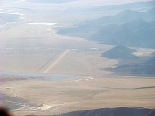
Fukche Advanced Landing Ground is an airfield in the Demchok sector of the union territory of Ladakh, India. It was built shortly before the 1962 Sino-Indian War and was revived in 2008. It is located adjacent to Koyul, 34 km northwest of Demchok.

The Western Air Command (WAC) is the regional command of Indian Air Force headquartered in New Delhi. It is the largest and most important Air Command of the IAF, comprising sixteen Air Force Bases (AFBs), and is responsible for aerial defence of North India.

<span class="mw-page-title-main">Nyoma</span> Village in Ladakh, India

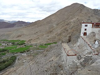
Nyoma is a principal village of southern Ladakh in India, the headquarters of an eponymous subdivision, tehsil, community development block and Indian Air Force Base in the Leh district. It is located on the bank of the Indus river after its 90-degree bend near Dungti east of Nyoma and before the valley narrows to a gorge near Mahe northwest of Nyoma. The Nyoma tehsil and subdivision cover all of southern Ladakh, including the Rupshu plains south of Nyoma, the Indus valley of Skakjung north of Nyoma, and the Hanle valley. Nyoma gompa, a Buddhist monastery, is located on the hill slope north of the village.

<span class="mw-page-title-main">Disputed territories of India</span>

There are several disputed territories of India. A territorial dispute is a disagreement over the possession or control of land between two or more states or over the possession or control of land by a new state and occupying power after it has conquered the land from a former state no longer currently recognized by the new state.

Chepzi, also spelt Chabji and Dripuche, is a village and military post in Tsamda County of Tibet in China, close to the border with India's Ladakh. Chepzi is close to Chumar in Ladakh's Rupshu region. There is evidence that the people of Chumar have traditionally used the farmlands in Chepzi, and the village was included in Ladakh during the British Raj. However, independent India excluded it from its border definition. The border has been witness to a large number of incursions by the Chinese People's Liberation Army since 2011.

Chumar or Chumur is a village and the centre of nomadic grazing region located in south-eastern Ladakh, India. It is in Rupshu block, south of the Tso Moriri lake, on the bank of the Parang River, close to Ladakh's border with Tibet. Since 2012, China has disputed the border in this area, though the Chumur village itself is undisputed.

Tawang Air Force station in Arunachal Pradesh in India has a functional heliport and fixed-wing "Advanced Landing Ground" (AGL) capable of handling Lockheed Martin C-130J Super Hercules transport aircraft. The Indian Air Force (IAF) has since 2016 upgraded 8 ALG in Arunachal Pradesh and made those operation by 2018, all of which has been offered for the operation of civil helicopter and flights for tourism and the UDAN scheme.

<span class="mw-page-title-main">Western Theater Command</span> Military command region of China

The Western Theater Command is one of the five theater commands of the People's Liberation Army, founded on 1 February 2016.

<span class="mw-page-title-main">Border Personnel Meeting Point</span> India/China army consultation locations

Border Personnel Meeting points are locations along the disputed Sino-Indian territories on Line of Actual Control (LAC) where the armies of both countries hold ceremonial and practical meetings to resolve border issues and improve relations. While border meetings have been held since the 1990s, the first formal Border Personnel Meeting point was established in 2013. There are five meeting points: two in the Indian Union Territory of Ladakh, one in Sikkim, and two in Arunachal Pradesh in India's Central and Eastern sectors.

Mechuka Advanced Landing Ground is an Indian Air Force airstrip located at Mechuka in Shi Yomi district of Arunachal Pradesh, India. It is an Advance Landing Ground (ALG) of Indian Air Force.It is

Walong Advanced Landing Ground is an Indian Air Force airstrip located at Walong on the banks of Lohit River in Anjaw District of Arunachal Pradesh, India. It is nearly 50 km north of district headquarter at Hawai, nearly 30 km south of India-China LAC, and 70 km southwest of Diphu Pass near India-China-Myanmar tri-junction.

<span class="mw-page-title-main">India–China Border Roads</span> Indian government project to develop border roads

India–China Border Roads is a Government of India project for developing infrastructure along the Sino-Indian border by constructing strategic roads, including bridges and tunnels. The ICBR project is largely in response to Chinese infrastructure development along the borderlands with India.

Border infrastructure along the Sino-Indian border, which has several border areas disputed by both India and China, encompasses irrigation, roads, railways, airports, natural gas and oil pipelines, electricity grids, telecommunications, and broadcasting. In the context of the border tensions between India and China, many of these infrastructure projects in the borderlands are considered strategic in nature. Commentators have noted the infrastructure gap that existed, and still exists, between the infrastructure on the borderlands of India and China. For many decades, the approach taken to the construction of border infrastructure by China and India was significantly different, however, in terms of utilizing the natural resources of the borderlands for the needs of the country, both countries are said to have a similar approach.

Tsosib Sumkyil or Churup Sumkhel is the westernmost township of the Zanda County in the Ngari Prefecture, Tibet region of China. It borders India's Spiti region in Himachal Pradesh as well as Rupshu region in Ladakh. The region is watered by the Pare Chu river, a tributary of the Spiti River and an upstream tributary of the Sutlej river. China has ongoing border disputes with India for the southwestern border of the region near Kaurik and the northern border near Chumar.

References

  1. Scramble.nl, Indian Air Force Order of Battle Archived 22 January 2009 at the Wayback Machine , accessed October 2011
  2. "Maruti to vacate area within restricted zone of Gurugram Air Force station". timesofindia.indiatimes.com. India: The Times of India . Retrieved 30 December 2018.
  3. Kumar, Kumar. "Gurugram: 6,000 houses near air force ammunition depot face threat of demolition". indiatoday.in. India: India Today . Retrieved 30 December 2018.
  4. Verma, Sanjeev (2 February 2012). "Haryana allows illegal Hotel within restricted zone of Gurgaon Air Force Station". hindustantimes.com. India: Hindustan Times . Retrieved 30 December 2018.
  5. Indian Navy launches Information Fusion Centre to boost maritime security, The Week, 22 December 2018.
  6. Defence minister inaugurates Information Management and Analysis Centre (IMAC) in Gurgaon, GKToday.
  7. 1980, "Haryana Review", Volume 14, Page 47.
  8. 2017, Fridabad disaster management plan, Govt of Haryana, p23.
  9. 13 Nov 2016, Ground Threat for air warriors, Times of India.
  10. 1991, Sainik Samachar: The Pictorial Weekly of the Armed Forces, p26.
  11. "Himalayan Eagles land in Vadodara". newKerela.com. 1 September 2011. Archived from the original on 8 December 2015. Retrieved 7 November 2011.
  12. "Eye on India, China raises Tibet military command rank | Central Tibetan Administration". tibet.net. Retrieved 1 October 2016.
  13. "Twisting India's Chicken's Neck". lowyinstitute.org. Retrieved 18 July 2020.
  14. 1 2 3 4 India plans AGL strips, Deccan Herald, 2014.
  15. 1 2 Parma valley ALG, cogitasia.com.
  16. Joshi, Prateek (26 July 2016). "India's Growing Military Footprint in Eastern Ladakh: Facing China". cogitASIA Center for Strategic and International Studies (CSIS) Asia Policy Blog. Retrieved 23 December 2021.
  17. O'Donnell, Frank; Bollfrass, Alexander K. (March 2020). "The Strategic Postures of China and India: A Visual Guide". Belfer Center for Science and International Affairs . Retrieved 23 December 2021.
  18. 1 2 3 4 Himachal Pradesh: Demand for airstrip in Spiti area, Times of India, 17 July 2020.
  19. To counter China, Nyoma airfield in Ladakh to be full-fledged base in 2 years, The Tribune, 5 Jan 2023.
  20. 1 2 Eyeing national security, Uttarakhand, ITBP to improve border infrastructure, Hindustan Times, 18 July 2020.
  21. 1 2 3 4 5 6 IAF to have seven AGL in Arunachal Pradesh, Economic Times, 2018.
  22. 1 2 "Upgraded Advanced Landing Grounds at Ziro and Along Inaugurated". Archived from the original on 13 March 2016. Retrieved 13 March 2016.
  23. "Walong landing ground in Arunachal Pradesh ready for operations". Archived from the original on 31 October 2015.
  24. 1 2 "UDAN reaches Arunachal Pradesh; first commercial flight flagged off | Business Standard News". Archived from the original on 20 November 2018. Retrieved 19 November 2018.
  25. 1 2 "Commercial flight: Arunachal Pradesh finally gets connected with Guwahati by a commercial flight - the Economic Times". Archived from the original on 19 November 2018. Retrieved 19 November 2018.