List of Los Angeles Historic-Cultural Monuments in the San Fernando Valley

Last updated

This is a list of Los Angeles Historic-Cultural Monuments in the San Fernando Valley, California. It includes Historic-Cultural Monuments in the San Fernando Valley as well as the adjacent Crescenta Valley. In total, there are more than 70 Historic-Cultural Monuments (HCM) in the San Fernando and Crescenta Valleys. A handful of additional historic sites in the valleys have been designated as California Historical Landmarks or listed on the National Register of Historic Places. The sites that are within City of Los Angeles borders are covered by two commissions of the Los Angeles Department of City Planning: the North Valley Area Planning Commission and the South Valley Area Planning Commission. [1] They are designated by the City's Cultural Heritage Commission.

Contents

Overview of the Valley's Historic-Cultural Monuments

The Second Los Angeles Aqueduct Cascades near Sylmar, California Second Los Angeles Aqueduct Cascades, Sylmar.jpg
The Second Los Angeles Aqueduct Cascades near Sylmar, California

The Historic-Cultural Monuments in the San Fernando Valley are spread across the Valley from Chatsworth in the northwest to Studio City in the southeast, and from the City of Calabasas in the southwest to Tujunga and La Crescenta in the northeast.

When the Los Angeles Cultural Heritage Board was formed in 1962, its first-designated sites were HCM #1 (Leonis Adobe) and HCM #2 (Bolton Hall), both located in the San Fernando/Crescenta Valleys.

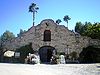
The oldest building in the Valley is the Convento Building at the Mission San Fernando Rey de España, which was built between 1808 and 1822. Other monuments directly related to the Mission San Fernando include the kiln in Chatsworth used to make bricks and tiles for the mission, the wells and settling basin in Sylmar used to supply water to the mission, and the Pioneer Cemetery where Mission Indians as well as Valley pioneers are buried.

In addition to the structures at the Mission, two adobe structures, Rómulo Pico Adobe built in 1834 and Leonis Adobe built in the 1840s, rank among the oldest in the Valley.

Eleven of the monuments located in the Valley have also been listed on the National Register of Historic Places. They are: Leonis Adobe, Bolton Hall, Rómulo Pico Adobe, the Convento Building at the Mission San Fernando, Campo de Cahuenga, Minnie Hill Palmer House, Los Encinos State Historic Park, Portal of the Folded Wings Shrine to Aviation, the Old Stage Coach Trail through the Santa Susana Mountains, and the North Hollywood and Van Nuys branch libraries.

Churches and other places of worship are well represented on the list, including the Chatsworth Community Church (1903), Faith Bible Church in Northridge (1917), the Saint Saviour's Chapel at Harvard-Westlake School in Studio City, and the David Familian Chapel of Temple Adat Ari El at the Valley's first Jewish synagogue in North Hollywood.

The role of trees in the development of the Valley is celebrated with monument listings for a 1,000-year-old oak tree in Encino (removed in 1996), 114 Himalayan Deodar trees along White Oak in Granada Hills, 76 mature olive trees along Lassen Street in Chatsworth, and 300 pepper trees lining in Canoga Avenue in Woodland Hills.

Current and former Historic-Cultural Monuments

HCM # [2] Landmark name [3] ImageDate designated [3] Locality [3] NeighborhoodDescription
1 Leonis Adobe Leonis Adobe, Calabasas (2008).JPG August 6, 196223537 Calabasas Rd.
34°09′27″N118°38′24″W / 34.15750°N 118.64000°W / 34.15750; -118.64000 (1. Leonis Adobe)
Calabasas, but within the limits of Woodland Hills, city of Los Angeles Monterey-style adobe residence built in the 1840s and occupied by Miguel Leonis ("one of the most colorful, influential and prominent figures of early Los Angeles") starting in the 1870s; now operated as a museum
2
(2329)
Bolton Hall BoltonHall Tujunga April2008.JPG August 6, 196210116 Commerce Ave.
34°15′10″N118°17′17″W / 34.25278°N 118.28806°W / 34.25278; -118.28806 (2. Bolton Hall)
Tujunga Community hall of utopian community built from native stone and local hillside materials in 1913. Owned by City of Los Angeles—open to the public.
7
(CHL 362)
(2394)
Romulo Pico Adobe Romulo Pico Adobe, MIssion Hills.JPG September 21, 196210940 Sepulveda Blvd.
34°16′8″N118°28′3″W / 34.26889°N 118.46750°W / 34.26889; -118.46750 (7. Pico, Romulo, Adobe)
Mission Hills Two-story adobe residence built in 1834 now operated by San Fernando Valley Historical Society; oldest residence in the San Fernando Valley
9 Shadow Ranch House Shadow Ranch, West Hills.jpg November 2, 196222633 Vanowen St.
34°11′39″N118°37′08″W / 34.194056°N 118.61902°W / 34.194056; -118.61902 (9. Shadow Ranch House)
West Hills Two story ranch house built between 1869 and 1872, partly adobe and partly redwood
14 Chatsworth Community Church Chatsworth Community Church (2008).jpg January 28, 196322601 Lassen St.
34°15′8″N118°37′14″W / 34.25222°N 118.62056°W / 34.25222; -118.62056 (14. Chatsworth Community Church)
Chatsworth Located in Oakwood Memorial Park, the oldest public building in Chatsworth, built in 1903; originally at 10051 Topanga Canyon Blvd.
23
(2355)
San Fernando Rey Mission Convento Building, Mission San Fernando Rey.jpg August 8, 196315151 San Fernando Mission Blvd.
34°16′23″N118°27′40″W / 34.27306°N 118.46111°W / 34.27306; -118.46111 (23. Mission San Fernando Rey de Convento Building)
Mission Hills Spanish mission built in the late 18th century; Convento Building (pictured) was rebuilt after the 1971 earthquake; 17th California Mission.
24 Encino Oak Tree Encino Oak Tree.jpg September 6, 1963Louise Ave., 210 feet (64 m) south of Ventura Blvd. Encino Oak tree estimated to be 1,000 years old; tree damaged, removed and delisted 1/1/1997; stump pictured at left.
29 Campo de Cahuenga Campo de cahuenga detail.jpg November 13, 19643919 Lankershim Blvd.
34°8′24″N118°21′42″W / 34.14000°N 118.36167°W / 34.14000; -118.36167 (29. Campo de Cahuenga)
Studio City Site of the signing of the Treaty of Cahuenga, January 13, 1847
31 Orcutt Ranch Horticulture Center Orcutt Ranch gate.jpg January 22, 196523555 Justice St.
34°13′01″N118°38′21″W / 34.21694°N 118.63917°W / 34.21694; -118.63917 (31. Orcutt Ranch Horticulture Center)
Canoga Park 1920 Rancho Sombra del Roble Spanish Colonial Revival Style adobe residence and estate of early oil tycoon and discoverer of fossils at La Brea Tar Pits
32 Saint Saviour's Chapel Harvard School Saint Saviour's Chapel, Harvard-Westlake School.jpg February 5, 19653700 Coldwater Canyon Ave.
34°08′23″N118°24′45″W / 34.13972°N 118.41250°W / 34.13972; -118.41250 (32. Saint Saviour's Chapel)
Studio City Chapel patterned after the Chapel at Rugby School in England; pews face center aisle
41 114 Deodar Trees Cedrus deodara along White Oak Ave at Tribune St in Granada Hills 2014.jpg August 3, 1966White Oak Ave. 34°16′03″N118°31′11″W / 34.26737°N 118.51966°W / 34.26737; -118.51966 (41. 114 Deodar Trees) Granada Hills Cedrus deodara trees native to the Himalayas, planted in 1932; between San Fernando Mission and San Jose St.
49 76 Mature Olive Trees 76 Mature Olive Trees (HCM -49).jpg May 10, 1967Lassen St.
34°15′00″N118°36′31″W / 34.25000°N 118.60861°W / 34.25000; -118.60861 (49. 76 Mature Olive Trees)
Chatsworth Olive trees planted in late 19th Century lining both sides of Lassen St. between Topanga Canyon Blvd. and Farralone Ave.
50 Mission Wells and Settling Basin Mission Wells, Sylmar.jpg May 10, 1967Bleeker St. & Havana Ave.
34°17′31″N118°27′14″W / 34.29194°N 118.45389°W / 34.29194; -118.45389 (50. Mission Wells and Settling Basin)
Sylmar 
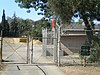
Remains of wells built of mission tiles around 1800 by Tongva Indians from the Mission San Fernando Rey de España to provide water to the mission; taken over by the Department of Water and Power in 1919, the 6-acre (24,000 m2) well site is the oldest existing source of water supply in the city, other than the Los Angeles River [4]
63 McGroarty Home February 4, 19707570 McGroarty Ter.
34°15′02″N118°17′52″W / 34.25056°N 118.29778°W / 34.25056; -118.29778 (63. McGroarty Home)
Tujunga Fieldstone and stucco house was home to California poet laureate, and Congressman John S. McGroarty, 1933–1944. Owned by City of Los Angeles—open to public.
92 Old Stage Coach Trail Property Old Stagecoach Trail Santa Susana3.png January 5, 1972Chatsworth Park South
34°15′40″N118°37′40″W / 34.26111°N 118.62778°W / 34.26111; -118.62778 (92. Old Stage Coach Trail Property)
Chatsworth Old Santa Susana Stage Road over Santa Susana Pass dating to the 1860s linked the San Fernando Valley with Simi Valley and Ventura
93 Pepper Trees January 5, 1972Canoga Ave. Woodland Hills Approximately 300 California Pepper Trees (Schinus molle) planted for Girard development in the 1920s forming an arch over Canoga Ave. between Ventura Blvd. and Saltillo St.
132 Stoney Point Outcroppings Stoney Point California.jpg November 20, 1974Chatsworth Park North
34°15′45″N118°37′04″W / 34.26250°N 118.61778°W / 34.26250; -118.61778 (132. Stoney Point Outcroppings)
Chatsworth Picturesque rock outcroppings in northwest corner of Chatsworth
133 Minnie Hill Palmer House Minnie Hill Palmer House, Chatsworth.jpg November 20, 1974Chatsworth Park South
34°15′40″N118°36′53″W / 34.26111°N 118.61472°W / 34.26111; -118.61472 (133. Palmer, Minnie Hill, House)
Chatsworth Cottage built in 1913, typical of structures built by pioneering homesteaders in the San Fernando Valley
135 Canoga Mission Gallery Canoga Mission Gallery.jpg December 4, 197423130 Sherman Way
34°11′20″N118°37′51″W / 34.18889°N 118.63083°W / 34.18889; -118.63083 (135. Canoga Mission Gallery)
West Hills Mission Revival Style stables built in 1936 by Francis Lederer, converted into a community arts center 1970s
141 Chatsworth Reservoir Kiln Site Chatsworth Reservoir Kiln Site.jpg April 2, 1975Southeast of intersection of Woolsey Canyon Rd. and Valley Circle Blvd.
34°14′08″N118°38′26″W / 34.23556°N 118.64056°W / 34.23556; -118.64056 (141. Chatsworth Reservoir Kiln Site)
West Hills La Calera; Site of kiln used to make bricks and tiles for the San Fernando Mission; fenced off and not accessible to public
152 Faith Bible Church Faith Bible Church Northridge.JPG April 17, 197618531 Gresham St.
34°13′51″N118°32′13″W / 34.23083°N 118.53694°W / 34.23083; -118.53694 (152. Faith Bible Church)
Northridge First church built in Northridge; Originally known as the Norwegian Lutheran Church; completed in 1917 in Gothic style
172 Stonehurst Recreation Center Building Stonehurst Recreation Center Building.jpg March 9, 19779901 Dronfield St.
34°14′56″N118°22′30″W / 34.2490°N 118.3749°W / 34.2490; -118.3749 (172. Stonehurst Recreation Center Bldg.)
Sun Valley Building constructed out of native stone c. 1930 by an Indian stonemason
184Tower of Wooden PalletsApril 19, 197815357 Magnolia Blvd.
34°14′58″N118°28′04″W / 34.24944°N 118.46778°W / 34.24944; -118.46778 (184. Tower of Wooden Pallets (site of))
Sherman Oaks Tower of 2,000 wooden pallets built in 1951 covering the grave of a child buried in 1869 (site of)
199 David Familian Chapel of Temple Adat Ari El September 20, 19785540 Laurel Canyon Blvd.
34°10′17″N118°23′47″W / 34.17139°N 118.39639°W / 34.17139; -118.39639 (199. Familian, David, Chapel of Temple Adat Ari El)
North Hollywood Chapel in the first synagogue building in the San Fernando Valley, dedicated in 1949 (site of)
201 Van Nuys Woman's Club Building Van Nuys Women's Club Building.jpg October 18, 197814836 Sylvan St.
34°11′03″N118°27′23″W / 34.18417°N 118.45639°W / 34.18417; -118.45639 (201. Van Nuys Woman's Club Bldg.)
Van Nuys Craftsman-style building completed in 1917, housing social club
202 Valley Municipal Building (Van Nuys City Hall) Valley Municipal Building.JPG October 18, 197814410 Sylvan St.
34°11′03″N118°26′50″W / 34.18417°N 118.44722°W / 34.18417; -118.44722 (202. Van Nuys Municipal Bldg.)
Van Nuys Art Deco style municipal building constructed in 1932; one of the Valley's most recognized landmarks
203 Baird House (Volunteer League Community Center) Baird House (Volunteer League), Van Nuys.jpg October 18, 197814603 Hamlin St.
34°11′24″N118°27′04″W / 34.19000°N 118.45111°W / 34.19000; -118.45111 (203. Baird House)
Van Nuys Bungalow-style residence built in 1921; later converted to use by the Volunteer League of the San Fernando Valley
204 Lederer Residence and Immediate Environments Lederer Residence, West Hills.jpg November 15, 197823134 Sherman Way
34°12′02″N118°37′54″W / 34.20056°N 118.63167°W / 34.20056; -118.63167 (204. Lederer Residence)
West Hills Mission Revival Style home built starting in 1934 with aged materials by Francis Lederer
228 Laurelwood Apartments Laurelwood Apartments 2.jpg April 22, 198011833-11847 Laurelwood Dr.
34°08′29″N118°23′25″W / 34.14139°N 118.39028°W / 34.14139; -118.39028 (228. Laurelwood Apartments)
Studio City Apartment building designed by noted architect, Rudolph Schindler, built in 1948
232 Department of Water and Power Building Department of Water and Power Building Lankershim 2015-05-02.jpg July 14, 19805106-5108 Lankershim Blvd.
34°09′48″N118°22′24″W / 34.163266°N 118.373374°W / 34.163266; -118.373374 (232. Department of Water and Power Bldg.)
North Hollywood Streamline Moderne structure designed by S. Charles Lee, built in 1939
290 La Reina Theater La Reina Theater, Sherman Oaks.jpg February 15, 198514626 Ventura Blvd.
34°09′05″N118°27′07″W / 34.15139°N 118.45194°W / 34.15139; -118.45194 (290. La Reina Theater)
Sherman Oaks Streamline Moderne movie theater designed by S. Charles Lee, built in 1938; converted to retail shops in 1987
293 The Magnolia The Magnolia, Sherman Oaks.jpg June 18, 198513242 Magnolia Blvd.
34°09′51″N118°25′18″W / 34.16417°N 118.42167°W / 34.16417; -118.42167 (293. Magnolia, The)
Sherman Oaks Spanish Colonial Revival residence built in the late 1920s
302
(2359)
Amelia Earhart Branch (North Hollywood Branch Library) North Hollywood Amelia Earhart Branch Library, Los Angeles.jpg June 27, 19865211 N. Tujunga Ave.
34°09′55″N118°22′45″W / 34.16528°N 118.37917°W / 34.16528; -118.37917 (302. Amelia Earhart Branch)
North Hollywood 
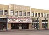
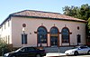
Spanish Colonial Revival style branch library built in 1929, originally dedicated to poet Sidney Lanier, later dedicated to aviator Earhart, a North Hollywood resident.
405 Pacific Electric Picover Railway Station January 11, 198916710 Sherman Way Van Nuys Pacific Electric Railway station, built partly in 1917 and partly in 1932; destroyed by fire in 1990
484 Oakridge and Grounds March 23, 199018650 Devonshire St.
34°15′24″N118°32′23″W / 34.25667°N 118.53972°W / 34.25667; -118.53972 (484. Oakridge)
Northridge English Manor style home built in 1937 for Barbara Stanwyck; later occupied by Jack Oakie; now owned by City of Los Angeles (2010).
488 Canoga Park (originally Owensmouth) Southern Pacific Railroad Station Southern Pacific Railroad Station in Owensmouth, circa 1915 (WVM78).jpg May 30, 199021355 Sherman Way Canoga Park Spanish Revival railroad station built in 1912; destroyed by fire in 1993
573 El Portal Theater El Portal Theater, North Hollywood 2014-11-18.jpg February 9, 19935265-5271 Lankershim Blvd.
34°10′01″N118°22′33″W / 34.16694°N 118.37583°W / 34.16694; -118.37583 (573. El Portal Theater)
North Hollywood Spanish Renaissance Revival theater, office and retail building completed in 1926
586
(CHL 753)
San Fernando Pioneer Memorial Cemetery San Fernando Pioneer Memorial Cemetery, Sylmar.jpg November 30, 199314400 Foothill Blvd.
34°19′15″N118°26′53″W / 34.32083°N 118.44806°W / 34.32083; -118.44806 (586. San Fernando Pioneer Memorial Cemetery)
Sylmar Second oldest cemetery in the San Fernando Valley, holds remains of early pioneers, Civil War veterans and Mission Indians
622 Taft House and Landscaping Taft House, Granada Hills.jpg April 16, 199616745 San Fernando Mission Blvd.
34°16′20″N118°29′49″W / 34.27222°N 118.49694°W / 34.27222; -118.49694 (622. Taft House)
Granada Hills 
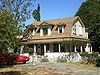
Late 19th Century Victorian house; features wood siding and trim, shingled gambrel roof, double hung windows, dormers and a wraparound porch supported by turned wood columns; home for matriarch of the influential Taft family.
629 Adams Residence Adams Residence, Reseda.jpg October 4, 19967400 Tampa Ave.
34°12′17″N118°33′11″W / 34.20472°N 118.55306°W / 34.20472; -118.55306 (629. Adams Residence)
Reseda Small house designed by Lloyd Wright, also known as "Mat House" [5]
638"El Paradiso"March 18, 199711468 Dona Cecilia Dr.
34°07′39″N118°23′04″W / 34.12750°N 118.38444°W / 34.12750; -118.38444 (638. "El Paradiso")
Studio City Modern, space-age, 4,500-square-foot (420 m2) house designed by Raphael Soriano, built in 1964, with 28 aluminum sliding doors [6]
644 Stone House LA-HCM 644 Stone House 8642 Sunland Blvd (2014).jpg December 19, 19878642 Sunland Blvd.
34°13′38″N118°21′57″W / 34.2272°N 118.3658°W / 34.2272; -118.3658 (644. Stone House)
Sun Valley American Craftsman style house built in 1925, with rock walls, gabled roofs, arched window openings, square tower, and a stone chimney
645 Harvester Farms Harvester Farms, Chatsworth.jpg December 19, 199722049 Devonshire St.
34°15′27″N118°36′28″W / 34.25750°N 118.60778°W / 34.25750; -118.60778 (645. Harvester Farms)
Chatsworth Site was the headquarters of the Palomino Horse Association of America; barn (pictured) was the birthplace of Mr. Ed
683 Chase Knolls Garden Apartments Chase Knolls Garden Apartments, Sherman Oaks.jpg July 11, 200013401 W. Riverside Dr.
34°09′27″N118°25′30″W / 34.15750°N 118.42500°W / 34.15750; -118.42500 (683. Chase Knolls Garden Apartments)
Sherman Oaks Dairy farm converted to residential development in the late 1940s; 260 bungalows and apartment homes
700 Canoga Park Branch Library Canoga Park Branch Library.jpg September 20, 20007260 N. Owensmouth Ave.
34°12′09″N118°36′05″W / 34.20250°N 118.60139°W / 34.20250; -118.60139 (700. Canoga Park Branch Library)
Canoga Park Branch library built in 1959, designed by Bowerman & Hobson
718 Ward House July 30, 200214501 Mulholland Dr.
34°07′56″N118°26′55″W / 34.13222°N 118.44861°W / 34.13222; -118.44861 (718. Ward House)
Sherman Oaks
740 The Serulnic House January 13, 20063947 Markridge Rd.
34°15′03″N118°15′59″W / 34.25083°N 118.26639°W / 34.25083; -118.26639 (740. Serulnic House)
La Crescenta Hillside house designed by Richard Neutra for Neutra's secretary and her husband, a musician with the Los Angeles Philharmonic; built in 1952
742 First Los Angeles Aqueduct Cascades VIEW NORTHWEST OF 1st AQUEDUCT CASCADES PORTAL - Los Angeles Aqueduct, Cascades Structures, Los Angeles, Los Angeles County, CA HAER CA-298-AH-1.tif February 4, 2003Near intersection of Foothill Blvd. and Balboa Blvd. Sylmar Terminus of the Los Angeles-Owens River Aqueduct, which brings water 338 miles (544 km) from the eastern slopes of the Sierra Nevada to Los Angeles; begun in 1905 and completed in 1913; also California Historic Landmark #653
750 The Munch Box The Munch Box, Chatsworth.jpg June 3, 200321532 W. Devonshire St.
34°15′25″N118°35′59″W / 34.25694°N 118.59972°W / 34.25694; -118.59972 (750. Munch Box)
Chatsworth 1950s hamburger stand with red and yellow coloring and a jet age overhang
759 Gerst Residence July 29, 20033437 Adina Dr.
34°07′43″N118°21′13″W / 34.12861°N 118.35361°W / 34.12861; -118.35361 (759. Gerst Residence)
Studio City House built in 1952
763 Studio Theatre at the Denis Building August 13, 20033433 Cahuenga Blvd. W.
34°07′55″N118°21′11″W / 34.13194°N 118.35306°W / 34.13194; -118.35306 (763. Studio Theatre at the Denis Bldg.)
Studio City Formerly the creative center for Ruth St. Denis, considered the "mother" of American modern dance whose most acclaimed student was Martha Graham; still in use for dance performances
782 El Encanto June 15, 200417360 Chase St.
34°13′21″N118°30′43″W / 34.22250°N 118.51194°W / 34.22250; -118.51194 (782. El Encanto)
Northridge Barn built in 1942 and converted into a residence by architect Henry Withey in 1947 for General Harris Malasky, who renamed it Black Hawk Ranch [7]
793 La Casa Sueno De Lewis Stone Ranch May 4, 20055700 N Rhodes Ave.
34°10′27″N118°24′11″W / 34.17417°N 118.40306°W / 34.17417; -118.40306 (793. La Casa Sueno De Lewis Stone Ranch)
Valley Village Spanish Colonial Revival structure built in 1930 with stucco cladding, low pitched tile roof, and decorative glazed tile and ironwork. Example of "Hollywood movie star" commissioned residential architecture.
828 Harry J. Wolff House Harry J. Wolff House, Sherman Oaks.jpg November 9, 20054000 N. Sunnyslope Ave.
34°08′32″N118°25′34″W / 34.14222°N 118.42611°W / 34.14222; -118.42611 (828. Wolff, Harry J., House)
Sherman Oaks House designed in 1938 by Rudolph Schindler
830 Blarney Castle January 13, 200610217 N. Tujunga Canyon Blvd.
34°15′07″N118°17′28″W / 34.25194°N 118.29111°W / 34.25194; -118.29111 (830. Blarney Castle)
Tujunga Well-known Sunland-Tujunga home built in 1919, modeled after an Irish castle
838 Oak Glen Ranch March 17, 20069811 N. Hillhaven Ave.
34°14′50″N118°17′26″W / 34.24722°N 118.29056°W / 34.24722; -118.29056 (838. Oak Glen Ranch)
Tujunga Built in 1908 by Flora Morgan, one of the first farmhouses in the Tujunga area
841 Weatherwolde Castle May 3, 200610629-10633 N. Commerce Ave.
34°15′43″N118°17′18″W / 34.26194°N 118.28833°W / 34.26194; -118.28833 (841. Weatherwolde Castle)
Tujunga Exotic-style house built in 1928, designed to resemble a French Normandy 16th-century castle
848 Eichler Homes-Foster Residence Eichler Homes - Foster Residence, Granada Hills.jpg August 16, 200617145 West Nanette St.
34°18′06″N118°30′21″W / 34.30167°N 118.50583°W / 34.30167; -118.50583 (848. Eichler Homes-Foster Residence)
Granada Hills 
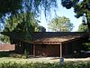
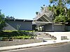
Mid-20th Century post-and-beam house designed by A. Quincy Jones, FAIA, and Frederick Emmons, AIA. for Eichler Homes; epitomizes modernist architecture and indoor-outdoor living with extensive glass walls opening to a large rear yard
860 Kallis House February 6, 20073580 N. Multiview Dr.
34°07′52″N118°21′45″W / 34.13111°N 118.36250°W / 34.13111; -118.36250 (860. Kallis House)
Studio City House designed by Rudolph Schindler, built in 1946; nestled into a hillside with a dramatic view overlooking of the Valley
869 Bakman House 10623 Riverside Drive.jpg May 16, 200710623 Riverside Dr.
34°09′09″N118°21′44″W / 34.15250°N 118.36222°W / 34.15250; -118.36222 (869. Bakman House)
Toluca Lake Spanish Colonial Revival house built in 1929 for Dan Bakman; one of the original homes in Toluca Lake [8]
883 Weddington House Weddington House, North Hollywood 2014-11-18.jpg August 15, 200711025 W. Weddington St.
34°10′02″N118°22′16″W / 34.16722°N 118.37111°W / 34.16722; -118.37111 (883. Weddington House)
North Hollywood First house built in the southeast San Fernando Valley
910 Riverside-Zoo Drive Bridge, No. 53C1298 Riverside-Zoo Drive Bridge, No. 53C1298, LAHCM 910, view from northwest, 2014.jpg January 30, 2008Between Victory Blvd. and Zoo Dr.
34°09′22″N118°17′39″W / 34.1562°N 118.2943°W / 34.1562; -118.2943 (910. Riverside-Zoo Drive Bridge, No. 53C1298)
Griffith Park Built in 1938, this reinforced concrete bridge exhibits character-defining features of Art Deco-Streamline Moderne bridge design.
911
(2509)
Van Nuys Branch Library Van Nuys Branch Library, Van Nuys.JPG February 13, 200814555 Sylvan St.
34°11′5″N118°26′59″W / 34.18472°N 118.44972°W / 34.18472; -118.44972 (911. Van Nuys Branch)
Van Nuys Old branch library building (1927)--fine example of Spanish colonial style—no longer used as a library
917 Roland E. Hill House April 23, 20083268 N. Bennett Dr
34°07′34″N118°20′54″W / 34.125977°N 118.348282°W / 34.125977; -118.348282 (917. Roland E. Hill House)
Studio City French Eclectic storybook style, designed by Roland E. Hill, 1926. [9] [10]
918 Lydecker Hilltop House May 14, 20083820 Buena Park Dr.
34°08′21″N118°23′21″W / 34.139071°N 118.389112°W / 34.139071; -118.389112 (918. Lydecker Hilltop House)
Studio City Streamline Moderne house built in 1939 for Howard "Babe" Lydecker known as one of Hollywood's early geniuses of special effects
932 Clarence G. Badger Residence July 29, 20087128 Woodrow Wilson Dr.
34°07′27″N118°20′54″W / 34.124178°N 118.348246°W / 34.124178; -118.348246 (932. Badger, Clarence G., Residence)
Studio City Spanish Colonial Revival house built in 1916 for early motion picture director Clarence Badger [11]
933 Kramer House September 25, 200812556 N. Middlecoff Pl. Granada Hills Mid-Century Modern Ranch, 1966. [12]
941 Stonehurst House March 4, 200910021 N. Stonehurst Ave.
34°15′6.63″N118°22′20.43″W / 34.2518417°N 118.3723417°W / 34.2518417; -118.3723417 (941. Stonehurst House)
Sun Valley 
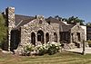
Residence built 1924 by Daniel Lawrence Montelongo, a stonemason of Native American descent. Craftsman style with Spanish Colonial Revival elements. [13]
946 Verdugo Hills of Peace Pioneer Cemetery March 4, 20097000 Parsons Trail
34°15′41.88″N118°17′0.47″W / 34.2616333°N 118.2834639°W / 34.2616333; -118.2834639 (946. Verdugo Hills of Peace Pioneer Cemetery)
Tujunga Established by Marshall Valentine Hartranft in 1922. [13]
952 Kaye Residence April 22, 20094754 Vanalden Ave.
34°9′23.21″N118°33′9″W / 34.1564472°N 118.55250°W / 34.1564472; -118.55250 (952. Kaye Residence)
Tarzana Designed by Gregory Ain, built 1963. [14]
974 Van Dekker House February 26, 201019950 W. Collier St. Woodland Hills Modern 1940 house designed by Rudolph Schindler. [15]
975 Sepulveda Unitarian Universalist Society Sanctuary ("The Onion") Sepulveda Unitarian Universalist Society Sanctuary aka The Onion 2016-03-13.jpg February 26, 20109550 N. Haskell Avenue 34°14′39.22″N118°28′30.41″W / 34.2442278°N 118.4751139°W / 34.2442278; -118.4751139 (975. Sepulveda Unitarian Universalist Society Sanctuary ("The Onion")) North Hills 
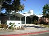
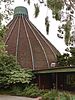
"Built in 1964... Modern style church sanctuary... hosted several political events opposing the Vietnam War... designed by student of Richard Neutra." [15]
976 Corbin Palms House February 26, 20106118 Jumilla Ave. 34°10′54.93″N118°33′49.21″W / 34.1819250°N 118.5636694°W / 34.1819250; -118.5636694 (976. Corbin Palms House) Woodland Hills 
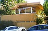
"Built in 1955... Modern Ranch style single-family residence designed by... Palmer & Krisel, who designed several Mid-Century Modern neighborhoods." [15]
977 Idle Hour Café Idle Hour Cafe North Hollywood 2015-02-15.jpg February 26, 20104824 Vineland Ave. 34°9′30.27″N118°22′12.75″W / 34.1584083°N 118.3702083°W / 34.1584083; -118.3702083 (977. Idle Hour Café) North Hollywood "Constructed in 1941... appears to be the last barrel-shaped building in Los Angeles from the early 20th century period of Programmatic design." [15]
978 Lankershim Reading Room February 26, 201010940 Sepulveda Blvd. 34°16′8″N118°28′3″W / 34.26889°N 118.46750°W / 34.26889; -118.46750 (978. Lankershim Reading Room) Mission Hills "One-story, octagonal-shaped [1904] structure... last remaining building from the Lankershim Ranch." Relocated to the park at the Rómulo Pico Adobe (LAHCM #7) in 2001. [15]
981 Margaret and Harry Hay House 3132 N. Oakcrest Dr.
34°7′31.8″N118°20′47.85″W / 34.125500°N 118.3466250°W / 34.125500; -118.3466250 (981. Margaret and Harry Hay House)
International Style by Gregory Ain, 1939, for Harry Hay, founder of the Mattachine Society. [16]

992
T.R. Craig Residence “Peppergate Ranch”March 9, 20118431 Pinelake Drive West Hills "One-story single-family residence, designed by Paul R. Williams in the Ranch Style, built in 1939. [17] [18]

Non-HCM historic sites recognized by state and nation

Code [19] Landmark name [3] ImageDate designated [3] Locality [3] NeighborhoodDescription
(CHL 689) Los Encinos State Historic Park Garnier Building at Rancho Los Encinos.JPG 16756 Moorpark St.
34°09′37″N118°29′54″W / 34.16028°N 118.49833°W / 34.16028; -118.49833 (CHL 689. Los Encinos State Historic Park)
Encino Rancho El Encino: "Franciscan padres used Encino as their headquarters while exploring the valley before establishing Mission San Fernando in 1797..."
(2702) Portal of the Folded Wings Shrine to Aviation & Museum Folded Wings Shrine portal.jpg 10621 Victory Blvd.
34°11′25″N118°21′13″W / 34.19028°N 118.35361°W / 34.19028; -118.35361 (2702. Portal of the Folded Wings)
North Hollywood Memorial to pioneers of aviation located on grounds of Valhalla Memorial Park Cemetery.
(CHL 150) Brand Park (Memory Garden) Brand Park Fountain, Mission Hills.jpg 15174 San Fernando Mission Blvd.
34°16′21″N118°27′43″W / 34.27250°N 118.46194°W / 34.27250; -118.46194 (CHL 150. Brand Park (Memory Garden))
Mission Hills Former Mission gardens across from Mission San Fernando Rey, now operated as a public park
(2179) Toluca Southern Pacific Depot Toluca Southern Pacific Depot and Pacific Electric Lankershim Station view from east 2014-11-23.jpg 11275 Chandler Blvd & 5351 Lankershim Blvd North Hollywood Former Southern Pacific and Pacific Electric station at the site of the current Red/Orange Line hub.
(2412) Rancho Del Norte 18904 Nordhoff St. & 9051 Wilbur Ave. Northridge
(2414) New Mission Theatre 9015 Wilbur Ave. Northridge Mission-style theater built in 1987 by Elisabeth Waldo for use by the Multi-Cultural Music and Art Foundation of Northridge
(2451) Phil's Diner Phil's Diner.jpg Formerly 11138 Chandler Blvd. Now 5230 Lankershim Blvd. 34°9′56.57″N118°22′29.72″W / 34.1657139°N 118.3749222°W / 34.1657139; -118.3749222 North Hollywood Diner built in the 1920s; moved and re-opened in 2008 at the corner of Lankershim and Weddington –- across from the El Portal Theater
(2517) Van Nuys Post Office Building Old Van Nuys Post Office.jpg 14530 Sylvan St.
34°11′04″N118°27′00″W / 34.18444°N 118.45000°W / 34.18444; -118.45000 (2517. Van Nuys Post Office Building)
Van Nuys Spanish Colonial style structure built in 1935; formerly the Van Nuys Post Office [20]
(2518) Masonic Temple (North Hollywood, California) Masonic Temple, North Hollywood, CA.jpg 5122-5124 Tujunga Ave.
34°09′49″N118°22′44″W / 34.16361°N 118.37889°W / 34.16361; -118.37889 (2518. Masonic Temple)
North Hollywood Mayan-style Masonic Temple in North Hollywood designed by architect Robert Stacy-Judd
(CHL 716) Griffith Ranch Sylmar and San FernandoFoothill Blvd. and Vaughn St.Ranch purchased by D.W. Griffith in 1912 in the northeast valley; The Birth of a Nation and many westerns were filmed on the ranch; a historic marker is located at Foothill Blvd. and Vaughn St. [21]

See also

Lists of L.A. Historic-Cultural Monuments

Other

Related Research Articles

<span class="mw-page-title-main">West Hills, Los Angeles</span> Neighborhood in Los Angeles, California, United States

West Hills is a neighborhood in the western San Fernando Valley region of the city of Los Angeles, California. It is bordered by mountain ranges to the west and the Los Angeles neighborhoods of Chatsworth to the north, Canoga Park to the east, and Woodland Hills to the south.

<span class="mw-page-title-main">Campo de Cahuenga</span> Historic house in California, United States

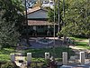
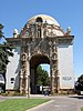
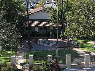
The Campo de Cahuenga, near the historic Cahuenga Pass in present-day Studio City, California, was an adobe ranch house on the Rancho Cahuenga where the Treaty of Cahuenga was signed between Lieutenant Colonel John C. Frémont and General Andrés Pico in 1847, ending hostilities in California between Mexico and the United States. The subsequent Treaty of Guadalupe Hidalgo of 1848, ceding California, parts of Colorado, Nevada, New Mexico, and Arizona to the United States, formally ended the Mexican–American War. From 1858 to 1861 the Campo de Cahuenga became a Butterfield Stage Station.

<span class="mw-page-title-main">Leonis Adobe</span> Historic house in California, United States

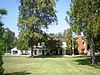
The Leonis Adobe is a historic adobe located in what is now Calabasas, California. One of the oldest surviving private residences in Los Angeles County and one of the oldest surviving buildings in the San Fernando Valley, it was built in 1844 and was occupied by the wealthy rancher Miguel Leonis until his death. Afterward, the property was the subject of a legal dispute between his common law wife Espiritu Chijulla, heirs, and a daughter born out of wedlock; the dispute lasted more than 15 years in the courts. In 1961, the adobe had fallen victim to vandalism, and its owner applied for a permit to raze the structure and erect a supermarket in its place. Preservationists succeeded in having the adobe declared Los Angeles Historic-Cultural Monument #1 in 1962, saving it from the wrecking ball at the last minute. It was listed on the National Register of Historic Places in 1975.

<span class="mw-page-title-main">Rómulo Pico Adobe</span> Historic house in California, United States

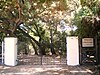
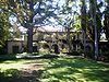
Rómulo Pico Adobe, also known as Ranchito Rómulo and Andrés Pico Adobe, was built in 1834 and is the oldest residence in the San Fernando Valley, making it the second oldest residence in Los Angeles. Built and owned by the Pico family of California, a prominent Californio family, the adobe is located in the Mission Hills section of the city and is a short distance from the San Fernando Mission. It was listed on the National Register of Historic Places in 1966.

<span class="mw-page-title-main">Minnie Hill Palmer House</span> Historic house in California, United States

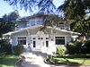
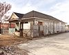
The Minnie Hill Palmer House, also known as The Homestead Acre, is the only remaining homestead cottage in the San Fernando Valley. The cottage is a redwood Stick-Eastlake style American Craftsman-Bungalow located on a 1.3-acre (0.53 ha) site in Chatsworth Park South in the Chatsworth section of Los Angeles, California.

<span class="mw-page-title-main">Shadow Ranch</span> Historic site in Los Angeles, California

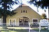
Shadow Ranch is a historic ranch house, built from 1869-1872 using adobe and redwood lumber, on the original Workman Ranch in the western San Fernando Valley of Los Angeles, California. For much of the 20th century it was in Canoga Park, but it is now within the boundaries of the West Hills community. The park is also allegedly haunted, owing to its grim history, and has been featured on Ghost Adventures.

<span class="mw-page-title-main">Los Angeles Historic-Cultural Monument</span> Heritage designation of the city of Los Angeles, California, U.S.

Los Angeles Historic-Cultural Monuments are sites which have been designated by the Los Angeles, California, Cultural Heritage Commission as worthy of preservation based on architectural, historic and cultural criteria.

<span class="mw-page-title-main">Chatsworth Community Church</span> Los Angeles Historic-Cultural Monument in California, U.S.

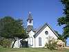
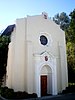
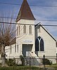
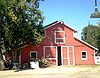
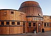
Chatsworth Community Church is a Los Angeles Historic-Cultural Monument in the Chatsworth section of Los Angeles, California.

<span class="mw-page-title-main">Lassen Street Olive Trees (Chatsworth, California)</span> Historic site in Los Angeles, California.

The Lassen Street Olive Trees, also known as 76 Mature Olive Trees, are a Los Angeles Historic-Cultural Monument located in the Chatsworth community of the northwestern San Fernando Valley, in Los Angeles, Southern California.

<span class="mw-page-title-main">Chatsworth Nature Preserve</span> Nature preserve in Los Angeles, California

The Chatsworth Nature Preserve (CNP) is a 1,325-acre (536 ha) open-space preserve located in the northwest corner of the San Fernando Valley in Los Angeles, California, United States. The preserve contains oak woodlands, savanna, riparian areas, grassland, vernal pools, and an Ecology Pond, all of which support more than 200 bird species and numerous mammals, amphibians and reptiles.

<span class="mw-page-title-main">Glendale Register of Historic Resources and Historic Districts</span> Historic register

The Glendale Register of Historic Resources and Historic Districts consist of buildings, structures, bridges, statues, trees, and other objects designated by the City of Glendale, California, as significant historic resources or historic districts.

<span class="mw-page-title-main">Chatsworth Calera</span> Historic site in Chatsworth, Los Angeles

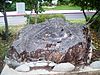
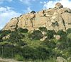
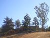
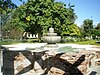
Chatsworth Calera also called Chatsworth Reservoir Kiln Site is one of the few surviving structures of the early 1800s lime industry. This kiln marked the introduction to California of the European industrial process for vitrifying limestone building blocks which were used in the construction of the San Fernando mission and other mission buildings. The word "Calera" is Spanish for "limestone quarry" or "limekiln". Chatsworth Calera is now located in Chatsworth, Los Angeles, California. in the Chatsworth Nature Preserve. At its peak there may have been up to five kilns at the site run by native Indian laborers. Chatsworth Calera registered a California Historical Landmark No. 911.

References

  1. "Monument Search Results Page". cityplanning.lacity.org. Retrieved April 18, 2018.
  2. Numbers in 1-999 series are L.A. Historic-Cultural Monuments; CHL numbers are state-designated California Historical Landmark sites; 2000 series denote LAHCM assigned numbers for federally designated sites. Blue colors represent higher designations as National Historic Landmarks and/or listing on the National Register of Historic Places; yellow represents sites that are L.A. Historic-Cultural Monuments without a higher designation. No color represents information is unavailable or the monument has been delisted. To resort on this column, refresh your browser.
  3. 1 2 3 4 5 6 Department of City Planning. "Designated Historic-Cultural Monuments". City of Los Angeles. Archived from the original on June 9, 2010. Retrieved June 15, 2010.
  4. Judson Grenier (Editor-in-chief) (1978). A Guide to Historic Places in Los Angeles County, p. 96. Kendall/Hunt Publishing Co. ISBN   0-8403-7501-8.{{cite book}}: |author= has generic name (help)
  5. http://www.laokay.com/AdamsResidence.htm
  6. "THIS OLD ALUMINUM HOUSE; FUTURISTIC VALLEY HOME HAS COLORFUL PAST. - Free Online Library". www.thefreelibrary.com. Retrieved April 18, 2018.
  7. "El Encanto". Charles J. Fisher.
  8. Office of Historic Resources, Newsletter, July 2007.
  9. Office of Historic Resources, Newsletter, July 2008.
  10. "CULTURAL HERITAGE COMMISSION CASE NO.: CHC-2007-5437-HCM" (PDF). lacity.org. Retrieved April 18, 2018.
  11. "Report on Clarence C. Badger Residence" (PDF). Cultural Heritage Commission.
  12. Office of Historic Resources Newsletter, October 2008.
  13. 1 2 Office of Historic Resources, Newsletter, April 2009.
  14. Office of Historic Resources, Newsletter, July 2009.
  15. 1 2 3 4 5 Office of Historic Resources, Newsletter, April 2010.
  16. Office of Historic Resources, Newsletter, July 2010.
  17. "L.A. Planning Dept.-OHR; April 2011 Newsletter" (PDF). lacity.org. Retrieved April 18, 2018.
  18. Paul Revere Williams: T.R. Craig (Harris) Residence - Photo gallery and history. Archived 2011-08-29 at the Wayback Machine
  19. Numbers in 1000 series denote LAHCM assigned numbers for state-designated sites; 2000 series denote LAHCM assigned numbers for federally designated sites. Blue colors represent higher designations as National Historic Landmarks and/or listing on the National Register of Historic Places; yellow represents sites that are L.A. Historic-Cultural Monuments without a higher designation. No color represents information is unavailable or the monument has been delisted. To resort on this column, refresh your browser.
  20. "Preserving Five Bits of History". Los Angeles Times. August 20, 1978.
  21. Judson Grenier (Editor-in-chief) (1978). A Guide to Historic Places in Los Angeles County, p. 98. Kendall/Hunt Publishing Co. ISBN   0-8403-7501-8.{{cite book}}: |author= has generic name (help)