List of airports in the Turks and Caicos Islands

Last updated

Map of Turks and Caicos Islands Turks and Caicos Islands-CIA WFB Map.png
Map of Turks and Caicos Islands
TurksandCaicosOMC.png

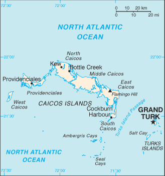
This is a list of airports in the Turks and Caicos Islands , sorted by location. The Turks and Caicos Islands are a British Overseas Territory located southeast of Mayaguana in the Bahamas and north of the island of Hispaniola. It consists of two groups of sub-tropical islands in the West Indies, the larger Caicos Islands and the smaller Turks Islands. The total population is about 36,000, of whom approximately 22,500 live on Providenciales in the Caicos Islands. Cockburn Town, the capital, is on Grand Turk Island.

Contents

Airports

Names shown in bold indicate the airport has scheduled passenger service on commercial airlines.

Island ICAO IATA Airport name Coordinates
Ambergris Cay (Caicos Islands)MBACHarold Charles International Airport 21°18′2″N71°38′28″W / 21.30056°N 71.64111°W / 21.30056; -71.64111 (Harold Charles International Airport)
Grand Turk Island (Turks Islands)MBGTGDT JAGS McCartney International Airport 21°26′40″N071°08′32″W / 21.44444°N 71.14222°W / 21.44444; -71.14222 (JAGS McCartney International Airport)
Middle Caicos (Caicos Islands)MBMCMDS Middle Caicos Airport 21°49′33″N071°48′09″W / 21.82583°N 71.80250°W / 21.82583; -71.80250 (Middle Caicos Airport)
North Caicos (Caicos Islands)MBNCNCA North Caicos Airport 21°55′03″N071°56′22″W / 21.91750°N 71.93944°W / 21.91750; -71.93944 (North Caicos Airport)
Pine Cay (Caicos Islands)MBPIPICPine Cay Airport 21°52′29.88″N72°5′32.69″W / 21.8749667°N 72.0924139°W / 21.8749667; -72.0924139 (Pine Cay Airport)
Providenciales (Caicos Islands)MBPVPLS Providenciales International Airport 21°46′25″N72°15′57″W / 21.77361°N 72.26583°W / 21.77361; -72.26583 (Providenciales International Airport)
Salt Cay (Turks Islands)MBSYSLX Salt Cay Airport 21°20′N071°12′W / 21.333°N 71.200°W / 21.333; -71.200 (Salt Cay Airport)
South Caicos (Caicos Islands)MBSCXSC South Caicos Airport 21°30′57″N071°31′43″W / 21.51583°N 71.52861°W / 21.51583; -71.52861 (South Caicos Airport)
West Caicos (Caicos Islands)MB01West Caicos Aerodrome 21°39′9″N072°27′57.6″W / 21.65250°N 72.466000°W / 21.65250; -72.466000 (West Caicos Airport)

See also

Map all coordinates using: OpenStreetMap  
Download coordinates as: KML

Related Research Articles

JAGS McCartney International Airport

JAGS McCartney International Airport, also known as Grand Turk International Airport, is an airport located 1 mile (1.6 km) south of Cockburn Town on Grand Turk Island in the Turks and Caicos Islands, an overseas territory of the United Kingdom. It is the second largest airport in the Turks & Caicos, after Providenciales International Airport.

References