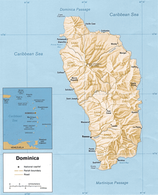
Dominica is an island in the Caribbean Sea, located about halfway between the French islands of Guadeloupe and Martinique. Its coordinates are 15 25 N, 61 20 W. It is known as "The Nature Island of the Caribbean" due to its spectacular, lush, and varied flora and fauna, which is protected by an extensive natural park system. It is the fourth largest island in the Eastern Caribbean with a population of people mainly of African descent.

Soufrière is a district on the Southwest coast of Saint Lucia in the West Indies. Soufrière was the former capital of Saint Lucia during times of French rule. It is now a small fishing port with an emerging tourism industry. It has several tourist sites, including a "drive-in" volcano, the Diamond Botanical Gardens with waterfall and historic mineral baths, plus the nearby beaches of Anse Chastanet to the north and Malgretout to the south.
The island nation of Saint Lucia is divided into 10 districts. The name Quarters or Quartiers originally came from the French period in Saint Lucia. The 2001 and 2010 Census of Saint Lucia refers to the first level administrative divisions as districts. The FIPS and ISO standards regularly called these divisions quarters or quartiers in French. The former district of Dauphin Quarter was merged into Gros Islet District and the former district of Praslin Quarter was merged into Micoud District.

The Pitons are two mountainous volcanic plugs, volcanic spires, located in Saint Lucia. Gros Piton is 798.25 m (2,618.9 ft) high and Petit Piton is 743 m (2,438 ft) high; they are linked by the Piton Mitan ridge. The Pitons are a World Heritage Site, 2,909 ha in size, and located near the town of Soufrière.

Saint Andrew is one of Dominica's 10 administrative parishes. It is bordered by St. John and St. Peter, St. Joseph, and St. David.
Saint David is one of Dominica's ten administrative parishes, located on the eastern side of the island. It is bordered by St. Andrew to the north; St. Joseph, St. Paul and St. George to the west; and St. Patrick to the south. It has an area of 131.6 km² (50.8 mi²), and has a population of 6,789.

Saint John is one of Dominica's 10 administrative parishes. It is bordered by St. Andrew to the east, and St. Peter and the Espagnole River to the south. It has an area of 59 km² (22.78 mi²).

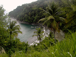
Scotts Head is a village on the southwest coast of Dominica, in Saint Mark Parish. In 2001, its population was 721. Predominantly a fishing village, Scotts Head overlooks Soufrière Bay, which is protected as the Soufrière Scotts Head Marine Reserve. It is also a popular snorkeling and diving site for tourists.
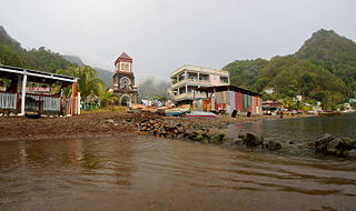
Soufrière is a village on the southwest coast of Dominica. It is the capital of Saint Mark Parish and has a population of 1,416 people.

Saint Lucia, an island nation in the Caribbean islands, has a relatively large tourism industry. Due to the relatively small land area of the country, most of the governmental promotion is performed by the state-operated Saint Lucia Tourism Authority, led by Executive Chairperson Agnes.
The Soufrière River is a river in the Soufrière Quarter on the island country of Saint Lucia. The French term "Soufrière" is a generic one referring to "Sulphury" volcanic peaks called La Soufrière or Soufrière Hills on each of St. Vincent, St. Lucia, Dominica, Guadeloupe.
Tourism in Dominica consists mostly of hiking in the rain forest and visiting cruise ships.

Soufrière is a town on the West Coast of Saint Lucia, in the eastern Caribbean Sea. The town and the surrounding district has a population of 7,935. It was colonized by the French and was the original capital of the island.
Petit Soufrière is a small village on the east coast of Dominica, upland from Petite Soufrière Bay in Saint David Parish. Located on the steep, rugged slopes of Morne Aux Delices at the end of the main road south from Castle Bruce, it is one of the most isolated villages in Dominica. The village immediately to its north is Saint Sauveur; to its south, though connected only by a hiking trail, is Rosalie.
The 2004 Les Saintes earthquake occurred at on November 21, 2004 with a moment magnitude of 6.3 and maximum European macroseismic intensity of VIII. The shock was named for Îles des Saintes "Island of the Saints", a group of small islands to the south of Guadeloupe, which is an overseas department of France. Although it occurred near the Lesser Antilles subduction zone, this was an intraplate, normal fault event. It resulted in one death, 13 injuries, and 40 people being made homeless, but the overall damage was considered moderate. A small, nondestructive tsunami was reported, but run-up and inundation distances were difficult to measure due to a storm that occurred on the day of the event. Unusual effects at a volcanic lake on Dominica were also documented, and an aftershock caused additional damage three months later.
Grand Bay is a parliamentary electoral district in Dominica. It includes the areas of Grand Bay, Bordieux and Montine. It came into effect in time for the 1975 Dominican general election. It has been represented by Edward Registe of the Dominica Labour Party since the 2019 general election.


