
Kaskaskia is a village in Randolph County, Illinois. Having been inhabited by indigenous peoples, it was settled by France as part of the Illinois Country. It was named for the Kaskaskia people. Its population peaked at about 7,000 in the 18th century, when it was a regional center. During the American Revolutionary War, the town, which by then had become an administrative center for the British Province of Quebec, was taken by the Virginia militia during the Illinois campaign. It was designated as the county seat of Illinois County, Virginia, after which it became part of the Northwest Territory in 1787. Kaskaskia was later named as the capital of the United States' Illinois Territory, created on February 3, 1809. In 1818, when Illinois became the 21st U.S. state, the town briefly served as the state's first capital until 1819, when the capital was moved to more centrally located Vandalia.

Prairie du Rocher is a village in Randolph County, Illinois, United States. Founded in the French colonial period in the American Midwest, the community is located near bluffs that flank the east side of the Mississippi River along the floodplain often called the "American Bottom". The population was 502 at the 2020 census.
Cahokia is a settlement and former village in St. Clair County, Illinois, United States, founded as a colonial French mission in 1689. Located east of the Mississippi River in the Greater St. Louis metropolitan area, as of the 2010 census, 15,241 people lived in the village. On May 6, 2021, the village was incorporated into the new city of Cahokia Heights.
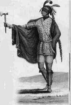
The Kaskaskia were one of the indigenous peoples of the Northeastern Woodlands. They were one of about a dozen cognate tribes that made up the Illiniwek Confederation, also called the Illinois Confederation. Their longstanding homeland was in the Great Lakes region. Their first contact with Europeans reportedly occurred near present-day Green Bay, Wisconsin, in 1667 at a Jesuit mission station.

The Territory of Illinois was an organized incorporated territory of the United States that existed from March 1, 1809, until December 3, 1818, when the southern portion of the territory was admitted to the Union as the State of Illinois. Its capital was the former French village of Kaskaskia on the Mississippi River. The northern half of the territory, modern Wisconsin and parts of modern Minnesota and Michigan became part of the Territory of Michigan in 1818.

The Illinois Country — sometimes referred to as Upper Louisiana —was a vast region of New France claimed in the 1600s in what is now the Midwestern United States. While those names generally referred to the entire Upper Mississippi River watershed, French colonial settlement was concentrated along the Mississippi and Illinois Rivers in what is now the U.S. states of Illinois and Missouri, with outposts on the Wabash River in Indiana. Explored in 1673 from Green Bay to the Arkansas River by the Canadien expedition of Louis Jolliet and Jacques Marquette, the area was claimed by France. It was settled primarily from the Pays d'en Haut in the context of the fur trade, and in the establishment of missions from Canada by French Catholic religious orders. Over time, the fur trade took some French to the far reaches of the Rocky Mountains, especially along the branches of the broad Missouri River valley. The French name, Pays des Ilinois, means "Land of the Illinois [plural]" and is a reference to the Illinois Confederation, a group of related Algonquian native peoples.

Fort de Chartres was a French fortification first built in 1720 on the east bank of the Mississippi River in present-day Illinois. It was used as the administrative center for the province, which was part of New France. Due generally to river floods, the fort was rebuilt twice, the last time in limestone in the 1750s in the era of French colonial control over Louisiana and the Illinois Country.
Louisiana or French Louisiana was an administrative district of New France. In 1682 the French explorer René-Robert Cavelier, Sieur de la Salle erected a cross near the mouth of the Mississippi River and claimed the whole of the drainage basin of the Mississippi River in the name of King Louis XIV, naming it "Louisiana". This land area stretched from the Great Lakes to the Gulf of Mexico and from the Appalachian Mountains to the Rocky Mountains. The area was under French control from 1682 to 1762 and in part from 1801 (nominally) to 1803.
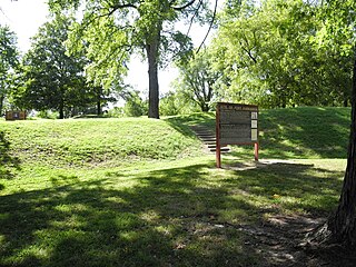
Fort Kaskaskia State Historic Site is a 200-acre (0.8 km²) park near Chester, Illinois, on a blufftop overlooking the Mississippi River. It commemorates the vanished frontier town of Old Kaskaskia and the support it gave to George Rogers Clark in the American Revolution.

Philippe-François de Rastel de Rocheblave also, known as, Philippe de Rocheblave and the Chevalier de Rocheblave, was a soldier and businessman in the Illinois Country, of Upper Louisiana, and later, a political figure in Lower Canada. He was sometimes referred to as the Chevalier de Rocheblave.

Louisiana, or the Province of Louisiana, was a province of New Spain from 1762 to 1801 primarily located in the center of North America encompassing the western basin of the Mississippi River plus New Orleans. The area had originally been claimed and controlled by France, which had named it La Louisiane in honor of King Louis XIV in 1682. Spain secretly acquired the territory from France near the end of the Seven Years' War by the terms of the Treaty of Fontainebleau (1762). The actual transfer of authority was a slow process, and after Spain finally attempted to fully replace French authorities in New Orleans in 1767, French residents staged an uprising which the new Spanish colonial governor did not suppress until 1769. Spain also took possession of the trading post of St. Louis and all of Upper Louisiana in the late 1760s, though there was little Spanish presence in the wide expanses of what they called the "Illinois Country".

"Indian Reserve" is a historical term for the largely uncolonized land in North America that was claimed by France, ceded to Great Britain through the Treaty of Paris (1763) at the end of the Seven Years' War—also known as the French and Indian War—and set aside for the First Nations in the Royal Proclamation of 1763. The British government had contemplated establishing an Indian barrier state in a portion of the reserve west of the Appalachian Mountains, bounded by the Ohio and Mississippi rivers and the Great Lakes. British officials aspired to establish such a state even after the region was assigned to the United States in the Treaty of Paris (1783) ending the American Revolutionary War, but abandoned their efforts in 1814 after losing military control of the region during the War of 1812.

John Duff, born John McElduff, or John Michael McElduff, because early court records referred to him as John Michael Duff, was a counterfeiter, criminal gang leader, horse thief, cattle thief, hog thief, salt maker, longhunter, scout, and soldier who assisted in George Rogers Clark's campaign to capture the Illinois country for the American rebel side during the Revolutionary War.
Renault is a small unincorporated community in the historic Renault Precinct of Monroe County, Illinois, United States.
Louis Groston de Saint-Ange de Bellerive (1700–1774), was an officer in the French marine troops in New France.
The history of St. Louis, Missouri from 1763 to 1803 was marked by the transfer of French Louisiana to Spanish control, the founding of the city of St. Louis, its slow growth and role in the American Revolution under the rule of the Spanish, the transfer of the area to American control in the Louisiana Purchase, and its steady growth and prominence since then.
Francisco Xavier Cruzat was a Spanish soldier who served as lieutenant governor of Upper Louisiana in New Spain from 1775 to 1778 and again from 1780 to 1787. He served as Interim Governor of East Florida in 1789.
Pedro Joseph Piernas was a Spanish military official who rose to the rank of commandant in 1768 and served as Lieutenant governor of Illinois between 1770 and 1775.

The Colonial history of Missouri covers the French and Spanish exploration and colonization: 1673–1803, and ends with the American takeover through the Louisiana Purchase
Robert Groston de Saint-Ange was a French military officer and commandant in the Illinois Country of New France.

