List of hillforts in Scotland

Last updated

Bennachie from the east, Aberdeenshire Bennachie from the east.jpg
Bennachie from the east, Aberdeenshire
Remains of the fort at Dunadd, Kilmartin, Argyll Scotland Dunadd.jpg
Remains of the fort at Dunadd, Kilmartin, Argyll
Animated LIDAR data of The Doon, or Drimadoon coastal hillfort, on the Isle of Arran
Traprain Law, East Lothian Traprain Law 4.jpg
Traprain Law, East Lothian
Arthur's Seat, viewed to the north-north-east from Blackford Hill Trig Point Blackford Hill Trig Point - geograph.org.uk - 1025272.jpg
Arthur's Seat, viewed to the north-north-east from Blackford Hill Trig Point
Prospect from Craig Phadrig, looking westward along the southern shore of the Beauly Firth Beauly Firth from Craig Phadrig - geograph.org.uk - 621252.jpg
Prospect from Craig Phadrig, looking westward along the southern shore of the Beauly Firth
Edin's Hall Broch, Berwickshire EdinsHallBroch.jpg
Edin's Hall Broch, Berwickshire
Rock outcrop and pond, Peniel Heugh summit Rock outcrop and pond, Peniel Heugh summit - geograph.org.uk - 1870422.jpg
Rock outcrop and pond, Peniel Heugh summit
Dumbarton Rock on Clyde Water Brig Jeanie Johnston south west of Dumbarton Rock - geograph.org.uk - 203728.jpg
Dumbarton Rock on Clyde Water
Kite aerial photo of Peace Knowe in West Lothian Peace Knowe Hillfort.jpg
Kite aerial photo of Peace Knowe in West Lothian
Chesters Hill Fort, East Lothian Chesters 4.jpg
Chesters Hill Fort, East Lothian
Dry stone remains of White Catherun, out by Brechin WhiteCaterthun.jpg
Dry stone remains of White Catherun, out by Brechin

This article lists a few selected examples of hill forts in Scotland. The remains of at least 1,695 hillforts have been counted throughout the country as a whole, [1] most predominantly on the Scottish mainland, and also including on some of the Scottish islands. One of the highest concentrations of historic hillforts in Europe, according to the Trimontium Trust, is in the Scottish Borders, including particularly in the historic county of Berwickshire. Hill forts in Scotland typically date from the Bronze and Iron Ages, but post-Roman inhabitation of many sites is also important. The remains today typically survive only as earthworks with occasional traces of structural stone in varying quantity. Remains of vitrified forts are also found throughout Scotland.

Contents

Contents
See also  | External links

Aberdeenshire

Angus

Argyll and Bute

Clackmannanshire

Dumfries and Galloway

East Lothian

City of Edinburgh

Fife

Highland

Midlothian

Moray

Perth and Kinross

Scottish Borders

According to the Trimontium Trust, the area of the Scottish Borders lays claim to as many as 408 identifiable hillfort sites, one of the highest concentrations in Europe.

South Lanarkshire

Stirling

West Dunbartonshire

West Lothian

Western Isles

See also

Related Research Articles

<span class="mw-page-title-main">Edin's Hall Broch</span> 2nd-century broch near Duns in the Borders of Scotland

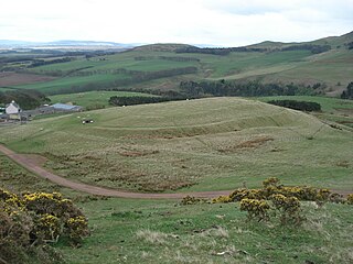
Edin's Hall Broch is a 2nd-century broch near Duns in the Borders of Scotland. It is one of very few brochs found in southern Scotland. It is roughly 28 metres in diameter.

<span class="mw-page-title-main">Auchencrow</span> Village in Scottish Borders, Scotland, UK

Auchencrow is a small village in the Scottish Borders area of Scotland, by the Lammermuir range of hills, and near Reston.

Sorbie is a small village in Wigtownshire, Machars, within the Administration area of Dumfries and Galloway Council, Scotland.

Mochrum is a coastal civil and Church of Scotland parish situated to the east of Luce Bay on the Machars peninsula and 8 miles (13 km) southwest of Wigtown and in the historical county of Wigtownshire in Galloway, Scotland. It covers 22,000 acres (8,900 ha) and is approximately 10 miles (16 km) in length and 5 miles (8.0 km) in breadth. The parish contains the eponymous village of Mochrum, as well as Port William and the clachan of Elrig.

Glasserton is a civil parish in Dumfries and Galloway, south-west Scotland. It is on the Machars peninsula, in the traditional county of Wigtownshire. The parish is about 8 miles (13 km) in length, varying in breadth from 1 to 3 miles, and contains 13,477 acres (54.54 km2).

<span class="mw-page-title-main">Sheldon stone circle</span> Stone circle in Aberdeenshire, Scotland

Sheldon stone circle is a prehistoric stone circle located to the south of Oldmeldrum in Aberdeenshire, Scotland.

<span class="mw-page-title-main">Dunnideer Castle</span> Ruined tower house in Insch, Aberdeenshire, Scotland

Dunnideer Castle, now ruined, was a tower house located near Insch, Aberdeenshire, Scotland. It was built c. 1260 partially from the remains of an existing vitrified hill fort in the same location. It consisted of a single rectangular tower of 15 m by 12.5 m with walls 1.9 m thick. Evidence suggests that a first-floor hall existed and that it had several floors.

Stoneykirk is an area and a village in the heart of the Rhins of Galloway, Wigtownshire, in the administrative council area of Dumfries and Galloway, Scotland nearly 10 miles (16 km) in length and 3+12 miles (5.6 km) in breadth, bounded on the east by the bay of Luce, and on the west by the Irish Channel, 5 miles (8 km) south of Stranraer.

<span class="mw-page-title-main">Castle Law</span> Iron Age hill fort in Midlothian, Scotland, UK

Castle Law is a hill south west of Fairmilehead in the Pentland Hills in Midlothian, Scotland.

Black Castle, East Lothian is an Iron Age hillfort with a number of defensive banks, located 5 kilometres (3.1 mi) south-east of Gifford, East Lothian, Scotland. It is south of the B6355 road, between Darent House and Green Castle hillfort.

Dùn Cholla is a hill fort located on the Inner Hebridean island of Colonsay, Scotland. The site is located at grid reference NR37759150.

<span class="mw-page-title-main">Whitsbury Castle</span> Iron Age hillfort in Hampshire, England

Whitsbury Castle, or Whitsbury Castle Ditches, is the site of an Iron Age univallate hillfort located near the village of Whitsbury in Hampshire. The fort is roughly pear-shaped, located on a chalk outcrop, and covering approximately sixteen acres. The defenses comprise two large ramparts with outer ditches and an additional counter scarp bank on the northern half. The original entrance was at the southwestern corner but has been destroyed by the construction of a post-medieval manor house. The site has been in use throughout the ages, with excavation revealing mesolithic activity, an association with a Bronze Age ranch boundary, an Iron Age hillfort settlement, followed much later by Anglo-Saxon renovation and reuse of the defences. The site is privately owned but is flanked externally on all sides but east by public bridleways.

<span class="mw-page-title-main">Dundurn, Scotland</span>

Dundurn is the site of a Pictish hillfort in what is now Strathearn in Perth and Kinross, Scotland.

<span class="mw-page-title-main">Loch Bowie</span> A lake in Dunbartonshire, Scotland

Loch Bowie is a small freshwater loch located in West Dunbartonshire, Scotland.

<span class="mw-page-title-main">Dun Cruinn</span>

Dun Cruinn is a prehistoric site about 10 kilometres (6.2 mi) north-west of Portree, on the Isle of Skye, Scotland. It is on the Skerinish Peninsula, between Loch Snizort Beag and Loch Eyre.

<span class="mw-page-title-main">Castle Knowe, Northumberland</span>

Castle Knowe, also known as Clinch Castle, is the site of an Iron Age hillfort in Northumberland, England, about 1 mile south-east of the village of Ingram. It is a scheduled monument.

References

  1. Morris, Steven (21 June 2017). "Hill fort hotspots in UK and Ireland mapped for first time in online atlas". The Guardian.
  2. The Doon Hillfort, Arran, by David Ross, Britain Express
  3. Drumadoon, Geological Society of Glasgow
  4. Kae Heughs, Barney Mains, The Megalithic Portal
  5. Kidlaw Hillfort, The Megalithic Portal
  6. "Moncreiffe Hill". Woodland Trust. Retrieved 20 December 2017.
  7. Broxmouth (site of), Stravaiging Around Scotland
  8. Drakemire Hillforts (Marygold), The Megalithic Portal
  9. Marygold Plantation, forts 845m W and 730m NW of MarygoldSM375, Historic Environment Scotland, Scheduled Monument
  10. Preston Cleugh Hillfort, The Megalithic Portal
  11. Marygoldhill Plantation (Marygold Plantation; Bunkle Edge), Atlas of Hillforts of Britain and Ireland, SC4104
  12. Chester Hillfort and Cultivation Terraces, Ancient Monuments, History on the Ground
  13. Cockburn Law, Stravaiging Around Scotland
  14. Cockburn Law, Canmore, National Record of the Historic Environment
  15. St Abb's Head (Kirk Hill; Colodaesburg), Atlas of Hillforts of Britain and Ireland, SC4150
  16. Duns Law Hillfort, The Megalithic Portal
  17. What were bronze age hillhorts, like Earnsheugh,used for?, Garden Visit, Garden Design and Landscape Architecture
  18. Fosterlands, fort 500m N of SM4998, Historic Environment Scotland, Scheduled Monument
  19. Fosterland Burn, Canmore, National Record of the Historic Environment
  20. Bogle Plantation, Gordon Castle, Canmore, National Record of the Historic Environment
  21. Habchester, fort 1100m ESE of Bastleridge, SM4637, Historic Environment Scotland, Scheduled Monument
  22. Habchester (Bastleridge), Atlas of Hillforts of Britain and Ireland, SC4153
  23. Hirsel Law, Canmore, National Record of the Historic Environment
  24. Hirsel Law, Atlas of Hillforts of Britain and Ireland, SC4078
  25. Hirsel Law Fort, SM12349, Historic Environment, Scotland. Scheduled Monument
  26. Mutiny Stones and Twin Law, Rambling Scot
  27. Primrose Hill Fort, The Megalithic Portal
  28. Raecleugh Head Hill, fort 690m NNW of Raecleugh Head, SM378, Historic Environment Scotland, Scheduled Monument
  29. Raecleughhead Hillfort, The Megalithic Portal
  30. Tollis Hill Hillfort, The Megalithic Portal
  31. Bowden Hill fort, Linlithgow, SM2283, Historic Environment Scotland, Scheduled Monument
  32. Bowden Hill, Canmore, National Record of the Historic Environment
  33. Castlethorn fort, Torphichen Hills, Stravaiging Around Scotland
  34. SC3690: Peace Knowe, Atlas of Hillorts of Britain and Ireland
  35. Peace Knowe, Canmore ID 49312, Canmore, National Record of the Historic Environment