Related Research Articles
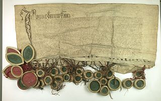
The Prussian Confederation was an organization formed on 21 February 1440 at Kwidzyn by a group of 53 nobles and clergy and 19 cities in Prussia, to oppose the arbitrariness of the Teutonic Knights. It was based on an earlier similar organization, the Lizard Union established in 1397 by the nobles of Chełmno Land.

Chekhovo is a settlement in Bagrationovsky District of Kaliningrad Oblast, Russia.

Smalininkai is a small city in Lithuania. It is located on the right bank of the Neman River, 12 km (7.5 mi) west from Jurbarkas, in the region of Lithuania Minor.
Nowe is a town in Świecie County, Kuyavian-Pomeranian Voivodeship, Poland, with 6,270 inhabitants (2004). It is located within the ethnocultural region of Kociewie.
In Poland, zaścianek was historically a village where petty nobility lived, especially in Mazovia and Podlachia. The derived adjective zaściankowy means out-of-the-way or narrow-minded.

Stary Lubotyń is a village in Ostrów Mazowiecka County, Masovian Voivodeship, in east-central Poland. It is the seat of the gmina called Gmina Stary Lubotyń. It lies approximately 15 kilometres (9 mi) north of Ostrów Mazowiecka and 102 km (63 mi) north-east of Warsaw.

Celiny is a village in the administrative district of Gmina Ożarowice, within Tarnowskie Góry County, Silesian Voivodeship, in southern Poland. It lies approximately 4 kilometres (2 mi) south of Ożarowice, 14 km (9 mi) east of Tarnowskie Góry, and 21 km (13 mi) north of the regional capital Katowice.
Główka is a village in the administrative district of Gmina Gołdap, within Gołdap County, Warmian-Masurian Voivodeship, in north-eastern Poland, close to the border with the Kaliningrad Oblast of Russia. It lies approximately 13 kilometres (8 mi) south-west of Gołdap and 123 km (76 mi) north-east of the regional capital Olsztyn. It is located in the historic region of Masuria.
Grabowo is a village in the administrative district of Gmina Gołdap, within Gołdap County, Warmian-Masurian Voivodeship, in north-eastern Poland, close to the border with the Kaliningrad Oblast of Russia. It lies approximately 13 kilometres (8 mi) south-west of Gołdap and 124 km (77 mi) north-east of the regional capital Olsztyn. It is located in the historic region of Masuria.
Suczki is a village in the administrative district of Gmina Gołdap, within Gołdap County, Warmian-Masurian Voivodeship, in north-eastern Poland, close to the border with the Kaliningrad Oblast of Russia. It lies approximately 6 kilometres (4 mi) south of Gołdap and 130 km (81 mi) north-east of the regional capital Olsztyn. It is located in the historic region of Masuria.
Kierzki is a village in the administrative district of Gmina Banie Mazurskie, within Gołdap County, Warmian-Masurian Voivodeship, in north-eastern Poland, close to the border with the Kaliningrad Oblast of Russia. It is located in the historic region of Masuria.
Kietlice is a settlement in the administrative district of Gmina Węgorzewo, within Węgorzewo County, Warmian-Masurian Voivodeship, in north-eastern Poland. It is located on the western shore of Lake Mamry in the region of Masuria, close to the border with the Kaliningrad Oblast of Russia.

Perły is a village in the administrative district of Gmina Węgorzewo, within Węgorzewo County, Warmian-Masurian Voivodeship, in north-eastern Poland. It is located in the region of Masuria, close to the border with the Kaliningrad Oblast of Russia.
Trygort is a village in the administrative district of Gmina Węgorzewo, within Węgorzewo County, Warmian-Masurian Voivodeship, in north-eastern Poland. It lies approximately 5 kilometres (3 mi) west of Węgorzewo and 92 km (57 mi) north-east of the regional capital Olsztyn. It is located on the northern shore of Lake Mamry in the region of Masuria, close to the border with the Kaliningrad Oblast of Russia.

Budry is a village in Węgorzewo County, Warmian-Masurian Voivodeship, in northern Poland, close to the border with the Kaliningrad Oblast of Russia. It is the seat of the gmina called Gmina Budry. It lies approximately 10 kilometres (6 mi) north-east of Węgorzewo and 105 km (65 mi) north-east of the regional capital Olsztyn. It is located in the historic region of Masuria.
Donskoye is a rural locality in the Ozyorsky District in the Kaliningrad Oblast, Russia. Population: 27 (2010 Russian census);

Adelsk is an agrotown in Grodno District, Grodno Region, Belarus. It serves as the administrative center of Adelsk selsoviet. It is located close to the border with Poland and 98 kilometres (61 mi) from Grodno. Its population is estimated at 661 inhabitants.
Hyeranyony is an agrotown in Iwye District, Grodno Region, Belarus. It serves as the administrative center of Hyeranyony selsoviet. It is located near the border with Lithuania and is known for the 16th-century Hieraniony Castle built by Albertas Goštautas. The village had a population of 1,278 in 2010.
Subotniki or Subbotniki is an agrotown in Iwye District, Grodno Region, Belarus. It serves as the administrative center of Subotniki selsoviet.
References
- 1 2 3 4 5 6 7 8 9 10 11 12 13 14 15 16 17 18 19 20 21 22 23 M. Kiełczewska; Wł. Chojnacki (1946). Okręg Mazurski: mapa komunikacyjno-administracyjna wraz z niemiecko-polskim i polsko-niemieckim słownikiem nazw (Map). 1:500,000 (in Polish). Poznań.
- ↑ Słownik geograficzny Królestwa Polskiego i innych krajów słowiańskich, Tom III (in Polish). Warszawa. 1882. p. 592.
{{cite book}}: CS1 maint: location missing publisher (link) - ↑ Słownik geograficzny Królestwa Polskiego i innych krajów słowiańskich, Tom VIII (in Polish). Warszawa. 1887. p. 142.
{{cite book}}: CS1 maint: location missing publisher (link) - ↑ Słownik geograficzny Królestwa Polskiego i innych krajów słowiańskich, Tom II (in Polish). Warszawa. 1881. p. 118.
{{cite book}}: CS1 maint: location missing publisher (link) - ↑ Słownik geograficzny Królestwa Polskiego i innych krajów słowiańskich, Tom II (in Polish). Warszawa. 1891. p. 345.
{{cite book}}: CS1 maint: location missing publisher (link) - ↑ Słownik geograficzny Królestwa Polskiego i innych krajów słowiańskich, Tom I (in Polish). Warszawa. 1880. p. 724.
{{cite book}}: CS1 maint: location missing publisher (link) - ↑ Słownik geograficzny Królestwa Polskiego i innych krajów słowiańskich, Tom X (in Polish). Warszawa. 1889. p. 315.
{{cite book}}: CS1 maint: location missing publisher (link) - ↑ Słownik geograficzny Królestwa Polskiego i innych krajów słowiańskich, Tom II (in Polish). Warszawa. 1881. p. 574.
{{cite book}}: CS1 maint: location missing publisher (link) - ↑ Słownik geograficzny Królestwa Polskiego i innych krajów słowiańskich, Tom IV (in Polish). Warszawa. 1885. p. 733.
{{cite book}}: CS1 maint: location missing publisher (link) - ↑ Słownik geograficzny Królestwa Polskiego i innych krajów słowiańskich, Tom XII (in Polish). Warszawa. 1892. p. 443.
{{cite book}}: CS1 maint: location missing publisher (link)