
Located in Oceania, Tonga is a small archipelago in the South Pacific Ocean, directly south of Samoa and about two-thirds of the way from Hawaii to New Zealand. It has 169 islands, 36 of them inhabited, which are in three main groups – Vavaʻu, Haʻapai, and Tongatapu – and cover an 800-kilometre (500-mile)-long north–south line. The total size is just 747 km2 (288 sq mi). Due to the spread out islands it has the 40th largest Exclusive Economic Zone of 659,558 km2 (254,657 sq mi).

Nukuʻalofa is the capital and largest city of Tonga. It is located on the north coast of the island of Tongatapu, in the country's southernmost island group.

George Tupou I, originally known as Tāufaʻāhau I, was the first king of modern Tonga. He adopted the name Siaosi, the Tongan equivalent of George, after King George III of the United Kingdom, when he was baptized in 1831. His nickname was Lopa-ukamea, meaning iron cable.
The Tuʻi Tonga is a line of Tongan kings, which originated in the tenth century with the mythical ʻAhoʻeitu, and withdrew from political power in the fifteenth century by yielding to the Tuʻi Haʻatakalaua. The title ended with the death of the last Tuʻi Tonga, Sanualio Fatafehi Laufilitonga, in 1865, who bequeathed the ancient title and its mana to his nephew, Fatafehi Tu'i Pelehake, who was the Tu'i Faleua, or Lord of the Second House. Tu'i Pelehake surrendered the title and its privileges to his father-in-law, King George Tupou I, who united its power and prestige with that of the Tu'i Kanokupolu, Tu'i Vava'u, and Tu'i Ha'apai titles to establish the modern-day institution of the Tongan Crown. Though the title is no longer conferred, the ancient line remains unbroken and is represented by the noble title of Kalaniuvalu.

Haʻapai is a group of islands, islets, reefs, and shoals in the central part of Tonga. It has a combined land area of 109.30 square kilometres (42.20 sq mi). The Tongatapu island group lies to its south, and the Vavaʻu group lies to its north. Seventeen of the Haʻapai islands are inhabited. Their combined population is 5,419. The highest point in the Ha‘apai group, and in all of Tonga, is on Kao, which rises almost 1,050 metres (3,440 ft) above sea level.

Peau Vavaʻu Ltd was an airline based at the Pacific Royale Hotel in Nukuʻalofa, Tongatapu, Tonga. It operated domestic services. Its main base was Fuaʻamotu International Airport, Tongatapu, with hubs at Lifuka Island Airport and Vavaʻu International Airport.

The Legislative Assembly of Tonga is the unicameral legislature of Tonga.

ʻEua is an island in the kingdom of Tonga. It is close to Tongatapu, but forms a separate administrative division. It has an area of 87.44 km2 (33.76 sq mi), and a population in 2021 of 4,903 people.
Early general elections under a new electoral law were held in Tonga on 25 November 2010. They determined the composition of the 2010 Tongan Legislative Assembly.

Hunga Tonga–Hunga Haʻapai is a submarine volcano in the South Pacific located about 30 km (19 mi) south of the submarine volcano of Fonuafoʻou and 65 km (40 mi) north of Tongatapu, Tonga's main island. It is part of the highly active Kermadec-Tonga subduction zone and its associated volcanic arc, which extends from New Zealand north-northeast to Fiji, and is formed by the subduction of the Pacific Plate under the Indo-Australian Plate. It lies about 100 km (62 mi) above a very active seismic zone.
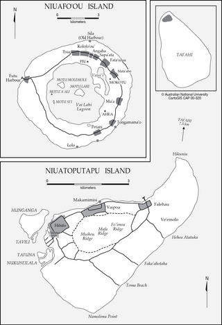
Niua is a division of the Kingdom of Tonga, namely the northernmost group of islands. It consists of three islands which together have an area of 71.69 km2 and a population of 1,150. The largest village is Hihifo on Niuatoputapu. Piu'o Tafahi is the highest point with an elevation of 560 m.

The 2010 Tongan Legislative Assembly was established following the 2010 elections, the first under a new system which saw the majority of seats elected by universal suffrage. The Taimi Media Network described it as "Tonga's first democratically elected Parliament".
Though it is no longer practised today, Tonga's ancient religion was practised for over 2,000 years, and some authors have characterised pre-contact Tonga as a theocracy. Christian missionaries arrived from the 1790s; they persuaded King George Tupou I to convert (1831) to Christianity. He ordered and strictly enforced that all Tongans become Christian and no longer practise the ancient polytheistic religion with its supreme god Tangaloa.
Liahona High School is a high school in Tonga owned and operated by the Church of Jesus Christ of Latter-day Saints. The school is named after the Liahona, a religious artifact described in the Book of Mormon, which gave a family direction in the wilderness. As of 2022, it is one of six LDS schools on Tongatapu, the main island of Tonga.
Tonga Cable System is a submarine fiber-optic cable system connecting Tonga with Fiji, where it connects to other international networks. It is 827 kilometres (514 mi) long and was activated in 2013. It has cable landing points at Sopu, a suburb of Nukuʻalofa in Tonga, and Suva, Fiji. The project was funded by Asian Development Bank and the World Bank.
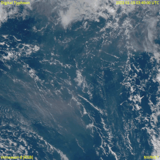
In December 2021, an eruption began on Hunga Tonga–Hunga Haʻapai, a submarine volcano in the Tongan archipelago in the southern Pacific Ocean. The eruption reached a very large and powerful climax nearly four weeks later, on 15 January 2022. Hunga Tonga–Hunga Haʻapai is 65 kilometres (40 mi) north of Tongatapu, the country's main island, and is part of the highly active Tonga–Kermadec Islands volcanic arc, a subduction zone extending from New Zealand to Fiji. On the Volcanic Explosivity Index scale, the eruption was rated at least a VEI-5. Described by scientists as a "magma hammer", the volcano at its height produced a series of four underwater thrusts, displaced 10 cubic kilometres (2.4 cu mi) of rock, ash and sediment, and generated the largest atmospheric explosion recorded by modern instrumentation.

ʻAtatā is an island in Tonga, near the capital city Nukuʻalofa. The island was completely evacuated after the 2022 Hunga Tonga–Hunga Ha'apai eruption and tsunami. Before the eruption, the island's population was 106.
Mango is a small island in Tonga, 9 kilometres south-east of the larger island of Nomuka, and part of the Nomuka or ʻOtu Muʻomuʻa group of islands, which are the southern part of the Haʻapai group. Mango had a population of 62 in the 2021 census.
Constituencies of Tonga are used for elections to the Legislative Assembly of Tonga.

Masilamea is a village on the island of Tongatapu in Tonga. The village had a population of 284 at the 2021 census.