List of islands of Namibia

Last updated

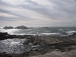
Halifax Island Halifax Island Namibia.JPG
Halifax Island

Namibia has many islands. Here are some of them:

Penguin Islands

The Penguin Islands consist of:

From north to south:
Namecoordinates
Hollam's Bird Island 24°38′S14°31′E / 24.633°S 14.517°E / -24.633; 14.517 (Hollam's Bird Island)
Mercury Island 25°43′09″S14°49′59″E / 25.719161°S 14.832948°E / -25.719161; 14.832948 (Mercury Island)
Ichaboe Island 25°43′S14°50′E / 25.717°S 14.833°E / -25.717; 14.833 (Ichaboe Island)
Black Rock 26°05′S14°58′E / 26.083°S 14.967°E / -26.083; 14.967 (Black Rock)
Staple Rock 26°22′S14°58′E / 26.367°S 14.967°E / -26.367; 14.967 (Staple Rock)
Marshall Reef 26°22′S14°58′E / 26.367°S 14.967°E / -26.367; 14.967 (Marshall Reef)
Boat Bay Rocks 26°25′S15°5′E / 26.417°S 15.083°E / -26.417; 15.083 (Boat Bay Rocks)
Seal Island 26°36′S15°9′E / 26.600°S 15.150°E / -26.600; 15.150 (Seal Island)
Penguin Island 26°37′S15°9′E / 26.617°S 15.150°E / -26.617; 15.150 (Penguin Island)
Halifax Island 26°39′S15°5′E / 26.650°S 15.083°E / -26.650; 15.083 (Halifax Island)
Graget Island 26°00′S15°11′E / 26.000°S 15.183°E / -26.000; 15.183 (Graget Island)
Albatross Rock 27°07′S15°13′E / 27.117°S 15.217°E / -27.117; 15.217 (Albatross Rock)
Possession Island 27°01′S15°13′E / 27.017°S 15.217°E / -27.017; 15.217 (Possession Island)
Pomona Island 27°12′S15°15′E / 27.200°S 15.250°E / -27.200; 15.250 (Pomona Island)
North Long Island 26°49′S15°8′E / 26.817°S 15.133°E / -26.817; 15.133 (North Long Island)
South Long Island 26°50′S15°8′E / 26.833°S 15.133°E / -26.833; 15.133 (South Long Island)
Black Rock 24°56′S14°48′E / 24.933°S 14.800°E / -24.933; 14.800 (Black Rock)
Black Sophie Rock 27°38′S15°31′E / 27.633°S 15.517°E / -27.633; 15.517 (Black Sophie Rock)
Plumpudding Island 27°38′S15°32′E / 27.633°S 15.533°E / -27.633; 15.533 (Plumpudding Island)
Sinclair Island (Roast Beef Island) 27°40′S15°32′E / 27.667°S 15.533°E / -27.667; 15.533 (Sinclair Island)
Little Roastbeef Islets 27°42′S15°32′E / 27.700°S 15.533°E / -27.700; 15.533 (Little Roastbeef Islets)

Related Research Articles

<span class="mw-page-title-main">Towns of the Faroe Islands</span>

This is a list of villages of the Faroe Islands.

<span class="mw-page-title-main">National Register of Historic Places listings in Staten Island</span>

List of the National Register of Historic Places listings in Richmond County, New York.

This is intended to be a complete list of properties and districts listed on the National Register of Historic Places on Manhattan Island below 14th Street, which is a significant portion of the New York City borough of Manhattan. In turn, the borough of Manhattan is coterminous with New York County, New York. For properties and districts in other parts of Manhattan Island, the mainland neighborhood of Marble Hill, and the other islands of New York County, see National Register of Historic Places listings in Manhattan. The locations of National Register properties and districts may be seen in an online map by clicking on "Map of all coordinates".

This is intended to be a complete list of historic properties and districts listed on the National Register of Historic Places located on islands other than Manhattan Island but still in New York County, New York. For all properties and districts in the borough of Manhattan, see National Register of Historic Places listings in New York County, New York. The locations of National Register properties and districts may be seen in an online map by clicking on "Map of all coordinates".

Fletcher Island is a Baffin Island offshore island located in the Arctic Archipelago in the territory of Nunavut. The island lies in Frobisher Bay, north of Newell Sound. The Hall Peninsula is to the east. Islands in the immediate vicinity include: Field Island to the east; Bruce Island to the northeast; Pike and Pugh Islands to the west.